Cross-generational change detection in classified LiDAR point clouds for a semi-automated quality control
Table of content
This project provides a set of scripts to detect changes between a reference point cloud and a new point cloud. The goal is to highlight areas of change in the new point cloud to make the control process faster.
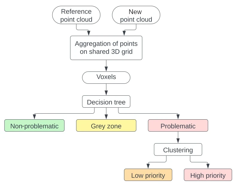
It performs a voxelization and compare the distribution of classes in the voxels. The changes are classified by type and criticality level. The global workflow is summarized on Figure 1.

Figure 1: Overview of the workflow for change detection and assignment of a criticality level to the detected changes.
The full documentation of the project is available on the STDL's technical website.
No specific hardware is needed. However, the RAM must be big enough for the dimension of the point cloud files.
We conducted successfully our tests on a machine with 16 GB of RAM and point cloud tiles of dimension 2 km x 2 km with an approximate density of 15-20 pts/m2 for the reference generation and 100 pts/m2 for the new generation.
- Python 3.10: the dependencies may be installed with either
piporconda, by making use of the providedrequirements.txtfile.
conda create -n <environment_name> python=3.10
conda activate <environment_name>
pip install -r requirements.txt- (Optional) LAStools: some pre-processing scripts rely on the function
las2lasfrom LAStools to reclassify the point clouds and modify the tiling. This function is in the open-source part of LAStools. The change detection process itself relies only on Python libraries.
In order to run the change detection, at least two point clouds are required, one acting as the reference and the other as the point cloud to control. The expected format is LAS or LAZ.
The workflow is based on the assumption that the two point clouds cover the same area and have the same coordinate system (i.e. no point cloud registration is performed).
It is necessary for the two tiles to share the same name, although the file formatting can differ.
| Tile 1 | Tile 2 | |
|---|---|---|
| ✅ | 2533_1155.las | 2533_1155.las |
| ✅ | tile_1.laz | tile_1.las |
| ❌ | 2533_1155.las | 2533000_1155000.las |
| ❌ | tile_prev.las | tile_new.las |
The reference and evaluated tiles are to be stored in two separate folders, whose paths must be provided in the YAML file with prev_folder and new_folder respectively.
The script retile_las.py was used in order to create tiles of the same dimension. It can be launched along the config file with:
python scripts/retile_las.py -cfg config.yml
Correspondence between the old and new classes is needed. It must be provided in the CSV format with the following fields. The field id indicates the class identifier in the new generation and the field matched_id indicates the corresponding identifier in the reference generation. A column class_name can be added for understandability purpose.
Some example data is provided to test the workflow. Two point clouds can be downloaded from the STDL's public cloud: the reference point cloud (2018) from the product swissSURFACE3D and the new point cloud (2022) produced by the Canton of Neuchâtel. They cover the exact same area.
In addition, the file giving the class equivalences between the two point clouds is provided in the data folder.
The downloaded point clouds should be placed in the data folder with the following structure:
.
└── data                                  # data folder
    ├── LiDAR_data
    |   ├── Neuchatel_2022                # folder for the new point clouds
    |   |   └── 2547000_1211500.laz
    |   └── clipped_swissSURFACE3D_2018   # folder for the reference point cloud
    |       └── 2547000_1211500.las
    └── class_equivalences.csv
The change detection can be launched with:
python scripts/change_detection.py -cfg config.ymlWith the default configuration, the change detection runs on all tiles provided in the input folder and produce a shapefile. The configuration can be adjusted through the file config.yml.
The process goes through the following substeps:
- Voxelization: Creates a common grid of voxels for the two point clouds and resume the class distribution in each voxel in the form of a dataframe.
- Decision tree: All voxels are assigned a criticality level.
- DBSCAN:The problematic voxels are filtered out if they are isolated, following a clustering made with the algorithm DBSCAN
- Visualization : The detections are converted in a file format for analysis: as a LAS file in 3D, as a shapefile in 2D.
If desired, each substep can be run individually on a single tile. For example:
python scripts/substeps/voxelisation.py -cfg config.ymlThe full decision tree to sort the voxels is given in Figure 2. It sorts the voxels by criticality level (non-problematic, grey zone, problematic) and by type of change, designated by the criticality number.
The criticality numbers correspond to the following definitions:
-
Grey zone:
- 7 - Increase in the unclassified points: Appearance of a voxel or change in the class proportions due to unclassified points in the new generation;
- 8 - Presence of extra classes in the area: Change in the class distribution due to extra classes present in the voxel compared to the reference generation. The neighboring voxels share the same class occupancy.
-
Problematic:
- 9 - Disappearance of a geometry: Disappearance, i.e. a voxel which contains points in the reference point cloud, but no points in the new point cloud. The neighboring voxels do not contains the same classes in the new generation;
- 10 - Appearance of a geometry: Appearance, i.e. a voxel which contains no points in the reference point cloud, but is filled in the new point cloud. The neighboring voxels do not share the same classes in the previous generation;
- 11- Isolated minor class change: Change in the class distribution due to extra classes present in the voxel compared to the reference generation. The neighboring voxels do not share the same class occupancy;
- 12 - Major changes in the distribution: Changes in the distribution for classes previously and newly present in the voxel;
- 13 - Noise: Presence of points classified as noise in the new point cloud.
