2023/10/22 update, Download Link: NTU4DRadLM
To test the dataset, our 4DRadarSLAM system is open-sourced at: 4DRadarSLAM
Paper on arxiv: Paper (ITSC 2023 accepted)
This repository provides a description and acquisition of NTU4DRadLM.
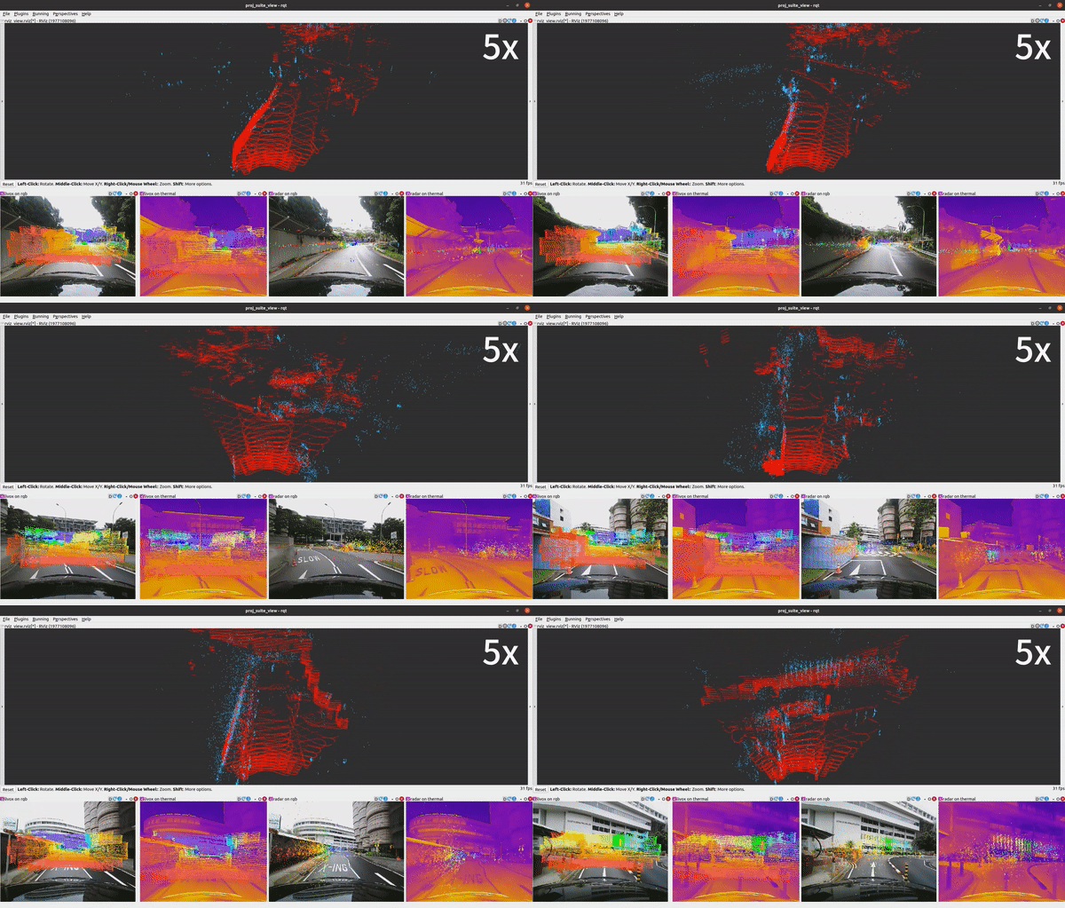
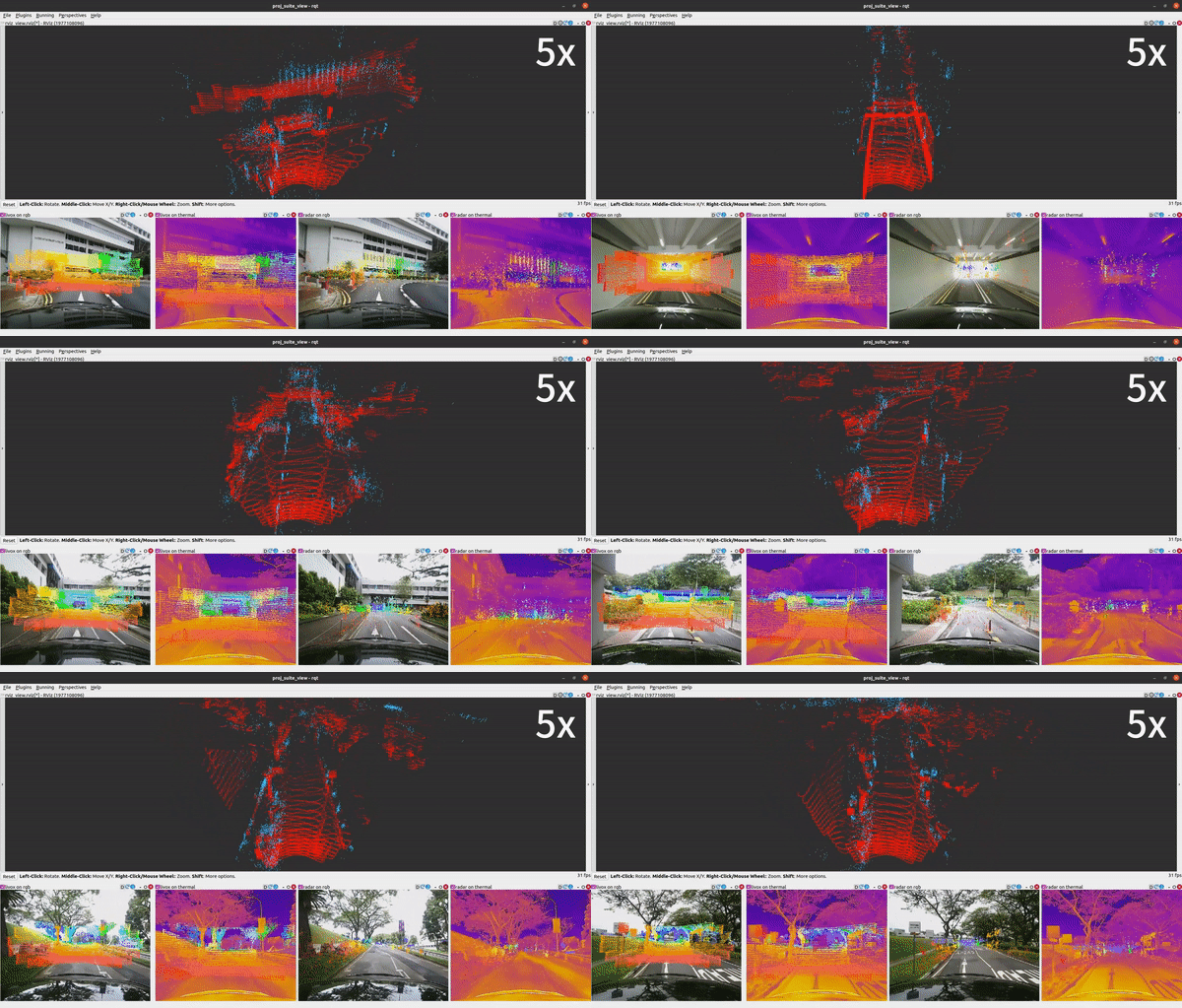
Example data from our dataset with 4D radar, 3D LiDAR, thermal camera and visual camera. Top: radar (blue) and lidar (red) point cloud. Bottom: projection result from LiDAR onto rgb, LiDAR onto thermal, radar onto rgb, and radar onto thermal.
NTU4DRadLM is a novel 4D radar dataset specifically proposed for research on robust SLAM, based on 4D radar, thermal camera, and IMU. Totally, the dataset is around 17.6km, 85mins, 50GB.
Simultaneous Localization and Mapping (SLAM) is moving towards a robust perception age. However, LiDAR- and visual- SLAM may easily fail in adverse conditions (rain, snow, smoke and fog, etc.). In comparison, SLAM based on 4D Radar, thermal camera and IMU can work robustly. But only a few literature can be found. A major reason is the lack of related datasets, which seriously hinders the research. Even though some datasets are proposed based on 4D radar in past four years, they are mainly designed for object detection, rather than SLAM. Furthermore, they normally do not include thermal camera. Therefore, in this paper, NTU4DRadLM is presented to meet this requirement.
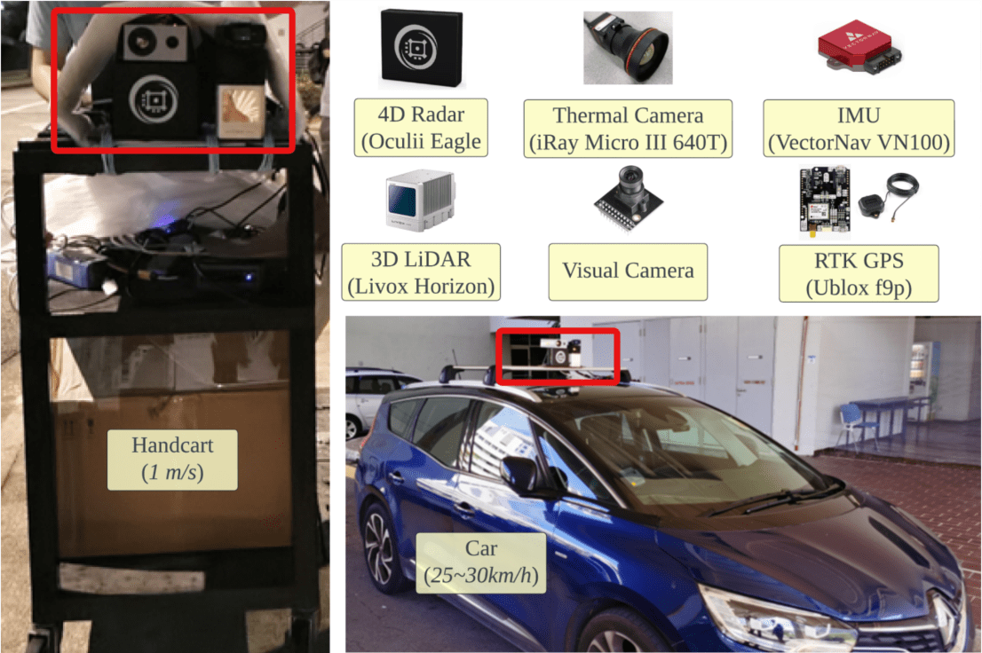
- It is the only dataset that simultaneously includes all 6 sensors: 4D radar, thermal camera, IMU, 3D LiDAR, visual camera and RTK GPS.
- Specifically designed for SLAM tasks, which provides fine-tuned ground truth odometry and intentionally formulated loop closures.
- Considered both low-speed robot platform and fast-speed unmanned vehicle platform.
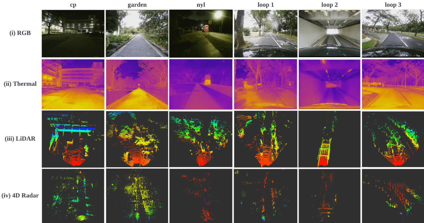
- Covered structured, unstructured and semi-structured environments.
- Considered both middle- and large- scale outdoor environments, i.e., the 6 trajectories range from 246m to 6.95km.
- Comprehensively evaluated three types of SLAM algorithms:
- pure 4D radar based
- 4D radar + IMU fused
- 4D radar + thermal camera fused
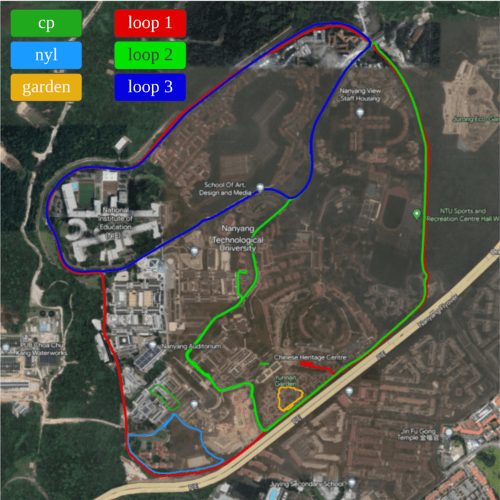
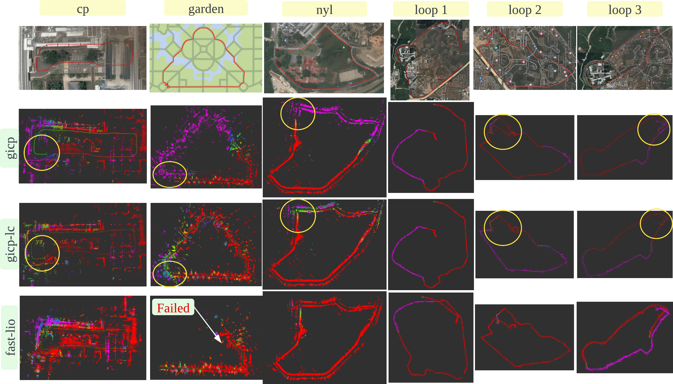
The six trajectories, cp: NTU carpark P (246m), garden: NTU Yunnan Garden (339m), nyl: Nanyang Link (1017m), loop1: big loop of NTU campus boundary (6.95km), loop2: loop of the south half of NTU campus (4.79km), loop3: loop of north half of NTU campus (4.23km).
The dataset is organized as follows.
NTU4DRadLM/
├── cp
│   └── cp_YYYY-MM-DD_N.bag (e.g. cp_2022-02-03_0.bag)
│   └── ...
│   └── gt_odom.txt
├── garden
│   └── ...
├── nyl
│   └── ...
├── loop1
│   └── ...
├── loop2
│   └── ...
├── loop3
│   └── ...
├── calib
│   └── intrinsic_xx.txt
│   └── ...
│   └── extrinsic_xx_to_xx.txt
│   └── ...
└── others
Information of the rosbags:
| Topic Name | Message Type | Description |
|---|---|---|
| /livox/imu | sensor_msgs/Imu | Livox built-in IMU |
| /livox/lidar | livox_ros_driver/CustomMsg | Livox LiDAR point cloud |
| /radar_enhanced_pcl | sensor_msgs/PointCloud | 4D radar enhanced point cloud |
| /radar_pcl | sensor_msgs/PointCloud | 4D radar point cloud |
| /radar_trk | sensor_msgs/PointCloud | 4D radar tracking objects |
| /rgb_cam/image_raw/compressed | sensor_msgs/CompressedImage | RGB image (compressed) |
| /thermal_cam/thermal_image/compressed | sensor_msgs/CompressedImage | Thermal image (compressed) |
| /ublox/fix | sensor_msgs/NavSatFix | GPS coordinate and covariance |
| /ublox/fix_velocity | geometry_msgs/TwistWithCovarianceStamped | Estimated ego-velocity from GPS |
| /vectornav/imu | sensor_msgs/Imu | VectorNav V100 IMU |
- 4DRadarSLAM: 4DRadarSLAM
- LiDAR-Visual-Inertial Odometry for ground truth generation: R2Live
- RPG trajectory evaluation: rpg_trajectory_evaluation
- TJ4DRadSet: TJ4DRadSet
- The View of Delft (VoD): view-of-delft-dataset
If you find this work is useful for your research, please consider citing:
Dataset
@INPROCEEDINGS{ZhangZhugeLiu2023ITSC,
  author={Zhang, Jun and Zhuge, Huayang and Liu, Yiyao and Peng, Guohao and Wu, Zhenyu and Zhang, Haoyuan and Lyu, Qiyang and Li, Heshan and Zhao, Chunyang and Kircali, Dogan and Mharolkar, Sanat and Yang, Xun and Yi, Su and Wang, Yuanzhe and Wang, Danwei},
  booktitle={2023 IEEE 26th International Conference on Intelligent Transportation Systems (ITSC)},
  title={NTU4DRadLM: 4D Radar-Centric Multi-Modal Dataset for Localization and Mapping},
  year={2023},
  volume={},
  number={},
  pages={4291-4296},
  keywords={Visualization;Simultaneous localization and mapping;Three-dimensional displays;Robot vision systems;Thermal sensors;Cameras;Trajectory},
  doi={10.1109/ITSC57777.2023.10422606}}
4DRadarSLAM
@INPROCEEDINGS{ZhangZhuge2023ICRA,
  author={Zhang, Jun and Zhuge, Huayang and Wu, Zhenyu and Peng, Guohao and Wen, Mingxing and Liu, Yiyao and Wang, Danwei},
  booktitle={2023 IEEE International Conference on Robotics and Automation (ICRA)},
  title={4DRadarSLAM: A 4D Imaging Radar SLAM System for Large-scale Environments based on Pose Graph Optimization},
  year={2023},
  volume={},
  number={},
  pages={8333-8340},
  doi={10.1109/ICRA48891.2023.10160670}}

