OGM2PGBM: Occupancy Grid Map to Pose Graph-based Map for long-term 2D LiDAR-based localization
This repo contains the following two applications:
OGM2PGBM: generate pose graph-based maps on 2D occupancy grid maps, which can be created from a TLS Point cloud or a BIM/CAD model. This pose graph-based maps can be used for accurate localization in changing and dynamic environments, as demostrated in our paper.
The following animation shows an overview of the method and compares AMCL and Cartographer; the latter can be applied after leveraging the Ogm2Pgbm package. It is clear that for AMCL is more difficult to keep track of the pose of the robot in comparison with the performance of Cartographer.
GMCL & CARTO/SLAM_toolbox: conbine the fast global localization feature of GMCL with the more accurate pose tracking performance of Cartographer/SLAM_toolbox
Additionally, it includes the packages amcl, gmcl, cartographer and slam_toolbox, so that they can be used and compared with a bagfile that should be located in the mounted directory ~/workspace easily.
Table of Contents
==================================
Requirements
If you plan to use our docker container, with all the methods installed (Warning: it requires >5 GB of space) you only need to install docker.
If you don't want to use docker and only want to use the Ogm2Pgbm package, you can install the content of this folder and use it as a normal catkin package.
If you still want to install all the different localization methods, you can have a look at the docker file and install the respective dependencies on your local machine.
OGM2PGBM
Principle
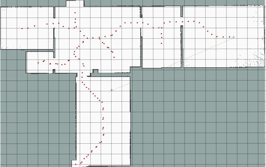
The workflow of OGM2PGBM is as follows, see the function new_map_callback(self, grid_map) for details:
- Subscribe map from the map topic
- Skeletonize the map and get its voronoi waypoint (see
self.skeletonize()) - Perform a coverage path planning on it (see
self.CPP())- Extract the farest endpoint pair first as the start and goal point
- Then dilate it with a 2x2 kernel to bold the centerline
- Do CPP wavefront algorithm and get the sorted waypoint
- Do a raytracing on the waypoints one by one, and publish the
/laserscantopic (seeself.raytracer())
It produces /tf, /clock, /odom, /scan topics with frame robot_map, robot_odom and robot_base_link.
Since /tf is needed, python2.7 is used in this script.
Running the code
Args
This package is a standard ros package and can be launched with roslaunch command.
args:
map_file: default value is/root/workspace/map/OGM_empty.pgm.yamlrecord: default value isfalse, the recorded bag can be found at/root/.ros/ogm2pgbm_sensordata.bag
Step by step
- First clone the repository.
git clone https://github.com/MigVega/Ogm2Pgbm.git
cd Ogm2Pgbm
With the launch file, we only need three steps to generate the base pbstream/posegraph based-map.
- run into the docker
bash autorun.shNote: If you get the error docker: Error response from daemon: could not select device driver "" with capabilities: [[gpu]].
install nvidia-container-toolkit with the following command sudo apt-get update && sudo apt-get install -y nvidia-container-toolkit
- launch the application with or without the args
roslaunch ogm2pgbm ogm2pgbm.launch map_file:=/root/workspace/map/OGM_empty.pgm.yaml record:=true The target bag file will be stored under /root/.ros/ogm2pgbm_sensordata.bag. By default, the demo bag will also be copied into this place. So you can also skip the second step if you want.
- After generating bagfiles, use Cartographer to generate pbstream or SLAM toolbox to generate posegraph maps. With the following command Cartographer will run in offline mode, which will generate pbstream quite fast, but without any visual output in rviz.
roslaunch cartographer_ros ogm2pgbm_my_robot.launch bag_filename:=/root/.ros/ogm2pgbm_sensordata.bag
You can also launch Slam_toolbox. (There will be some error report in the terminal, just ignore them and wait for some seconds.)
roslaunch slam_toolbox ogm2pgbm.launch bag_filename:=/root/.ros/ogm2pgbm_sensordata.bagThe target pbstream file will be generated automatically at /root/.ros/ogm2pgbm_sensordata.bag.pbstream after .
For slam_toolbox, you also need to click on the serialization button on the rviz plugin. The target files are also located at /root/.ros.
Note
- As it is already a package managed by catkin, if you have changed the src code or configuation inside the container, you need to do the following instructions to compile and install the package and source the env.
catkin_make_isolated --install --use-ninja --pkg ogm2pgbm
source install_isolated/setup.bash- All the node will be closed when the rviz is closed, including the rosbag node
- The parameters of cartographer when using OGM2PGBM scripts to generate pbstream are as follows (see
cartographer_ros/configuration_files/ogm2pgbm_my_robot.lua)
- remap
/scanor/odomin launch file if needed
GMCL & CARTO/SLAM_toolbox
This project combines the pros of the two algorithms, using the fast global localization feature of GMCL and the accurate pose tracking performance of Cartographer or SLAM toolbox.
- First, change the bagname in the line 11 of the file
~/catkin_ws/src/gmcl_carto/gmcl_carto.py. - Then, make sure the bagfile is located in the directory
/root/workspace. - At last, run the script directly
python ~/catkin_ws/src/gmcl_carto/gmcl_carto.py. - Do the same if you want to run
gmcl_carto/gmcl_slamtoolbox.pyinstead.
Citation
If you use this library for an academic work, please cite the original paper.
@inproceedings{ vega:2022:2DLidarLocalization,
	author = {Vega Torres, M.A. and Braun, A. and Borrmann, A.},
	title = {Occupancy Grid Map to Pose Graph-based Map: Robust BIM-based 2D- LiDAR Localization for Lifelong Indoor Navigation in Changing and Dynamic Environments},
	booktitle = {eWork and eBusiness in Architecture, Engineering and Construction: ECPPM 2022},
	editor = {Eilif Hjelseth, Sujesh F. Sujan, and Raimar Scherer},
	publisher = {CRC Press},
	year = {2022},
	month = {Sep},
	url = {https://publications.cms.bgu.tum.de/2022_ECPPM_Vega.pdf},
	isbn = {978-1-003-35422-2},
	doi = {10.1201/9781003354222-72}
}
