ST-MapMatching
版本
V2.0.0
描述
基于时间和空间特性的全局地图匹配算法(ST-Matching),一种针对低采样率的GPS轨迹的新颖全局地图匹配算法。算法的基础路网信息源为 OSM,可通过DigraphOSM自动下载。算法匹配过程考虑以下两个方面特征:
-
道路网络的空间几何和拓扑结构
-
轨迹的速度/时间约束。基于时空分析,构建候选图,从中确定最佳匹配路径。
输入WGS坐标系的GPS轨迹点集,输出途径的路段;
本算法为 MSRA《Map-Matching for Low-Sampling-Rate GPS Trajectories》的复现,并根据自己的认识有一些改动,中文解读可参考 CSDN文章。
调用说明
详见 demo.py
from mapmatching import build_geograph, ST_Matching

"""step 1: 获取/加载路网"""
# 方法1:
# 根据 bbox 从 OSM 下载路网,从头解析获得路网数据
# net = build_geograph(bbox=[113.930914, 22.570536, 113.945456, 22.585613],
#                      xml_fn="./data/network/LXD.osm.xml", ll=False)
# 将预处理路网保存为 ckpt
# net.save_checkpoint('./data/network/LXD_graph.ckpt')

# 方法2:
# 使用预处理路网
net = build_geograph(ckpt='./data/network/LXD_graph.ckpt')

"""step 2: 创建地图匹配 matcher"""
matcher = ST_Matching(net=net, ll=False)

"""step 3: 加载轨迹点集合,以打石一路为例"""
idx = 4
traj = matcher.load_points(f"./data/trajs/traj_{idx}.geojson").reset_index(drop=True)
res = matcher.matching(traj, top_k=5, dir_trans=True, details=False, plot=True,
                       simplify=True, debug_in_levels=False)

# 后续步骤可按需选择
"""step 4: 将轨迹点映射到匹配道路上"""
path = matcher.transform_res_2_path(res, ori_crs=True)
proj_traj = matcher.project(traj, path)

"""step 5: eval"""
matcher.eval(traj, res, resample=5, eps=10)
输入示例
{
"type": "FeatureCollection",
"name": "traj_debug_dashiyilu_0",
"crs": { "type": "name", "properties": { "name": "urn:ogc:def:crs:OGC:1.3:CRS84" } },
"features": [
{ "type": "Feature", "properties": {"geometry": { "type": "Point", "coordinates": [ 113.931956598012064, 22.575930582940785 ] } }},
{ "type": "Feature", "properties": {"geometry": { "type": "Point", "coordinates": [ 113.932515057750763, 22.575632036146079 ] } }},
{ "type": "Feature", "properties": {"geometry": { "type": "Point", "coordinates": [ 113.932920306714124, 22.575490522559665 ] } }},
{ "type": "Feature", "properties": {"geometry": { "type": "Point", "coordinates": [ 113.933781789624888, 22.575346314537452 ] } }},
{ "type": "Feature", "properties": {"geometry": { "type": "Point", "coordinates": [ 113.943190113338488, 22.575121559997108 ] } }},
{ "type": "Feature", "properties": {"geometry": { "type": "Point", "coordinates": [ 113.943816093693101, 22.575196482404341 ] } }}
]
}
注:
- 示例输入对应
./data/trajs/traj_4.geojson,其中geometry为唯一需要提供的字段,在vscode中可借助插件Geo Data Viewer可视化; - 输入轨迹点的坐标系默认为
wgs84,gcj02的轨迹需在调用函数load_points明确坐标系in_sys='gcj'; - 提供的预处理路网仅覆盖深圳南山区万科云城片区,并没有完成覆盖
./data/trajs中所有的测试用例。 若需测试所有用例,需自行调整 bbox 获取相应区域的路网。
输出示例
demo 输出
{
  #  输出状态码,0 为正常输出
  'status': 0,
  # 匹配路段 index
  'epath': [123, 124, 125, 126, 127, 128, 129, 130, 131, 132, 133, 134, 135],
  # 第一条路被通过的比例(即第一条路上, 第一个轨迹点及之后的部分的占比)
  'step_0': 0.7286440473726905,
  # 最后一条路被通过的比例(即最后一条路上, 最后一个轨迹点及之前的部分的占比)
  'step_n': 0.8915310605450645,
  # 概率
  'probs': {
      'prob': 0.9457396931471692,
      'norm_prob': 0.9861498301181256,
      'dist_prob': 0.9946361835772438,
      'trans_prob': 0.9880031610906268,
      'dir_prob': 0.9933312073337599}
 }
可视化效果如下:
- matcher.matching 将 plot 参数设置为 True
- 瓦片地图,需要安装 Tilemap
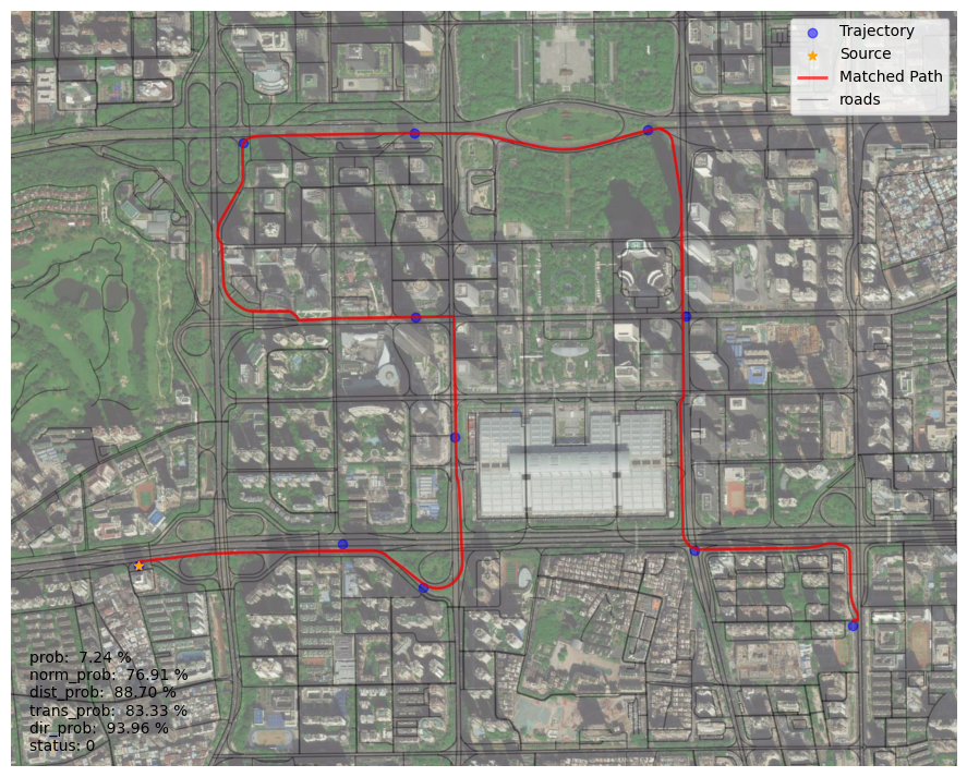
其他地图匹配效果
./data/trajs/traj_0.geojson 匹配效果
环境安装
详见 requirement.txt, 建议geopandas使用conda安装
conda create -n stmm python=3.9
conda activate stmm
conda install -c conda-forge geopandas==0.12.2
pip install -r requirement.txt
