Wagtail-Geo-Widget
A Google Maps widget for Wagtail that supports both GeoDjango PointField, StreamField and the standard CharField.
Requirements
- Python 2.7 / Python 3.5
- Wagtail 1.7+ and Django
Installation
Install the library with pip:
$ pip install wagtailgeowidget
Quick Setup
Make sure wagtail_geo_widget is added to your INSTALLED_APPS.
INSTALLED_APPS = (
    # ...
    'wagtailgeowidget',
)
Obtain a Google Maps API key and add it to your django settings GOOGLE_MAPS_V3_APIKEY
This should be enough to get started.
Usage
Standard CharField
Define a CharField representing your location, then add a GeoPanel.
from django.db import models
from wagtailgeowidget.edit_handlers import GeoPanel


class MyPage(Page):
    location = models.CharField(max_length=250, blank=True, null=True)

    content_panels = Page.content_panels + [
        GeoPanel('location'),
    ]
The data is stored as a GEOSGeometry string (Example: SRID=4326;POINT(17.35448867187506 59.929179873751934). To use the data, we recommend that you add helper methods to your model.
from django.contrib.gis.geos import GEOSGeometry

class MyPage(Page):
    # ...

    @property
    def point(self):
        return GEOSGeometry(self.location)

    @property
    def lat(self):
        return self.point.y

    @property
    def lng(self):
        return self.point.x
NOTE: While this implementation is quick and easy to setup, the drawback is that it will prevent you from making spatial queries, if that is what you need, use the GeoDjango/Pointer field implementation instead.
With address field
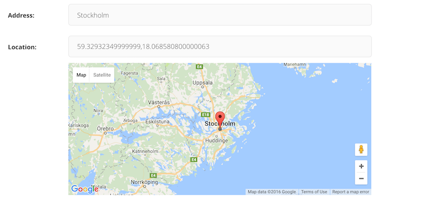
The panel accepts a address_field if you want to the map in coordiation with a geo-lookup (like the screenshot on top).
from django.db import models
from wagtailgeowidget.edit_handlers import GeoPanel


class MyPageWithAddressField(Page):
    address = models.CharField(max_length=250, blank=True, null=True)
    location = models.CharField(max_length=250, blank=True, null=True)

    content_panels = Page.content_panels + [
        GeoPanel('location', address_field='address'),
    ]
For more examples, look at the example.
StreamField
To add a map in a StreamField, import and use the GeoBlock.
from wagtail.wagtailcore.models import Page
from wagtail.wagtailcore.fields import StreamField
from wagtailgeowidget.blocks import GeoBlock

class GeoStreamPage(Page):
    body = StreamField([
        ('map', GeoBlock()),
    ])

    content_panels = Page.content_panels + [
        StreamFieldPanel('body'),
    ]
The data is stored as a json struct and you can access it by using value.lat / value.lng
<article>
    {% for map_block in page.stream_field %}
        <hr />
        {{ map_block.value }}
        <p>Latitude: {{ map_block.value.lat}}</p>
        <p>Longitude: {{ map_block.value.lng }}</p>
    {% endfor %}
</article>
With a address field
Make sure you define a field representing the address at the same level as your GeoBlock, either in the StreamField or in a StructBlock.
from wagtail.wagtailadmin.edit_handlers import StreamFieldPanel
from wagtailgeowidget.blocks import GeoBlock


class GeoStreamPage(Page):
    body = StreamField([
        ('map_struct', blocks.StructBlock([
            ('address', blocks.CharBlock(required=True)),
            ('map', GeoBlock(address_field='address')),
        ]))

    ])

    content_panels = Page.content_panels + [
        StreamFieldPanel('body'),
    ]
For more examples, look at the example.
GeoDjango (PointField)
First make sure you have GeoDjango correctly setup and a PointField field defined in your model, then add a GeoPanel among your content_panels.
from django.contrib.gis.db import models
from wagtailgeowidget.edit_handlers import GeoPanel


class MyPage(Page):
    location = models.PointField(srid=4326, null=True, blank=True)

    content_panels = Page.content_panels + [
        GeoPanel('location'),
    ]
With a address field
The panel accepts a address_field if you want to the map in coordiation with a geo-lookup (like the screenshot on top).
from django.contrib.gis.db import models
from wagtailgeowidget.edit_handlers import GeoPanel


class MyPageWithAddressField(Page):
    address = models.CharField(max_length=250, blank=True, null=True)
    location = models.PointField(srid=4326, null=True, blank=True)

    content_panels = Page.content_panels + [
        GeoPanel('location', address_field='address'),
    ]
For more examples, look at the example.
Settings
GOOGLE_MAPS_V3_APIKEY: Api key for google maps (required).GEO_WIDGET_DEFAULT_LOCATION: Default map location when no coordinates are set, accepts a dict with lat and lng keys (required, default is{'lat': 59.3293, 'lng': 18.0686}that is Stockholm/Sweden).GEO_WIDGET_ZOOM: Default zoom level for map (required, 7 is default).
Roadmap
- Editable map widget for GeoDjango PointerField
- Global default map location
- Streamfield map widget
Contributing
Want to contribute? Awesome. Just send a pull request.
License
Wagtail-Geo-Widget is released under the MIT License.