MapAnim
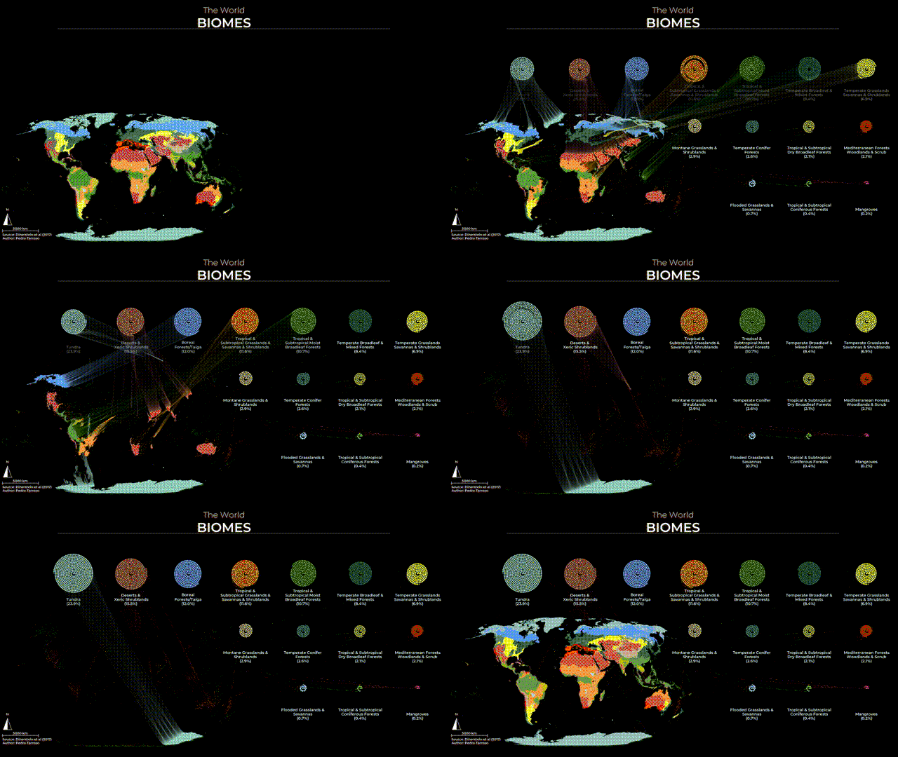
MapAnim is a Python script designed to create captivating visualizations of raster maps. It achieves this by animating the movement of data pixels, arranging the data in spirals, and visually representing the proportions of each class.
The script can be run from the command line and is highly customizable using simple text files. Included with the script is an illustrative example featuring world biomes.
NOTE: While the initial intent behind this script was simplicity of the code, streamlining its usage introduced some complexity. Due to my lack of time and a sporadic development effort, the script lacks a structured design which resulted in a kind of spaghetti code. Nevertheless, it does accomplishes its animating goals (although it was not fully tested)!
Installation
There are a few dependencies required to run the script. It necessitates a working installation of Python with numpy, matplotlib, and gdal. If you have these dependencies installed system-wide, you can use your system's Python.
Additionally, a mapanim.yml file is provided to create a Conda environment with he required dependencies. To set up the environment, ensure you have Conda installed, and then run the following commands:
conda env create -f mapanim.yml Activate the environment with:
conda activate mapanimNow, you can run the script within the mapanim environment.
Usage
The usage of the mapAnim.py script is straightforward. It requires three input files:
1.Raster File: Ideally in TIF format, this is a categorical map containing different classes to be animated.
2.Class Data: A CSV file that relates values in the raster to descriptions, color codes, and (x, y) targets for spiral packing.
3.Elements: A JSON file containing elements (text, lines, scale bars, north arrows) and customizations to be plotted alongside the map.
The script generates a sequence of image frames and saves them to a specified folder. These frames can be combined into a video file using any video editing software. The script offers multiple arguments for fine-tuning the output. For example, you can control the output size using the 'size' or '-s' argument and adjust the positioning of the raster map within the frame using the '--xlim' or '-x' and '--ylim' or '-y' arguments. These axis limits are in pixel units (1 unit equals 1 pixel) and are relative to the size of the original raster.
Keep in mind that the size of the raster can be limiting depending on available RAM. To address this, the script provides a resampling option, maintaining calculations of proportions with the original raster resolution. For a very large raster, you can decrease the resolution by a factor, e.g., '-r 4' for a factor of 4.
As an example, to generate a 4k output in a 'frame_output' folder for a raster requiring a factor 4 resampling, you can run the following command:
python mapAnim.py -r 4 -s 3840 2160 RASTER.tif CLASSDATA.csv ELEMENTS.json frame_outputNumerous other arguments are available for controlling animation properties. You can check the available options with:
python mapAnim.py -hClass data file
This file contains the necessary information to link integer values from the raster to a description, a hexadecimal color code, and an animation target (the center of the spiral). It should be formatted as a comma-separated values (CSV) file and must include a mandatory header with the following fields:
- value
- description
- color
- target_x
- target_y
The order of these fields is flexible, but it's crucial to use the correct field names as specified above. You can refer to the example file for the proper formatting.
Elements file
This file contains all the additional elements that can be plotted alongside the raster map. It adheres to a specific JSON format specifying the element type, position, and optional labeling. It also accommodates extra parameters that can be passed to the plotting functions of Matplotlib. Currently, the script supports the following elements:
- Text
- Lines
- Scalebar
- North Arrow
Please note that the size of the scalebar must be calculated based on the raster's resolution. For example, if your original raster has a 90-meter resolution, a 250-kilometer scale would require a size of 250,000 / 90 = 2,778 units. If the raster is resampled, the scale size should be recalculated based on the resampled resolution.
For more detailed information, please refer to the example file provided
Example
The provided example employs data from the world biomes from Dinerstein et al (2017).
The original data was converted into a raster format with a 1000-meter resolution and projected to a Natural Earth projection. It's worth noting that this example does not provide latitude-corrected proportions (which might be addressed in a future version of the script) with the poles showing larger areas than the equator. However, it effectively demonstrates the process of animating a map with the script.
To better illustrate the usage of different fonts, the script uses the free google font Montserrat (light and semi-bold). You need to get the fonts in your working directory first. You can obtain the fonts here.
To run the example, install the necessary dependencies, copy the script to your working directory, create an output folder named "frames" and execute the following command:
python mapAnim.py -r 4 -s 3840 2160 example/biomes.tif example/classdata.csv example/elements.json frames