geoform-template-js
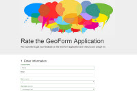
GeoForm is a configurable template for form based data editing of a Feature Service. This application allows users to enter data through a form instead of a map’s pop-up while leveraging the power of the Web Map and editable Feature Services. This will geo-enable data and support workflows by lowering the barrier of entry for completing simple tasks. This template can be used to gather input from outside of an organization and collect valuable content for collaboration.
- Map: Choose the web map used in your application.
- Title: Customize the title of the application.
- Logo: Choose a logo to display in the application.
- Description: Describe the form.
- Editable Layer: Choose the editable Feature Service used for collecting the input data.
- Fields: Select which fields to display and collect data within the form.
- Color Scheme: Choose the color scheme of the application.
- Mobile: A responsive web application that adapts to a resolution using Twitter’s Bootstrap framework.
- Share: Enable sharing using Twitter or Facebook or email.
The GeoForm template can be accessed via the ArcGIS template gallery or item details. The application source code can be downloaded for further customization and hosted on your own web server.
Instructions
- Download and unzip the .zip file or clone the repo.
- Web-enable the directory.
- Access the .html page.
- See the readme.html page for configuration options.
Adding The Template To Your ArcGIS Online Organization
See how you can add this template to your organization as an early adopter.
Configuring The Template
This template includes an application builder. If you're using this template via ArcGIS.com, you can take advantage of this builder while logged into ArcGIS and by configuring the published application.
If you are not using ArcGIS Online applications, you can configure this template by editing the defaults.js in the config folder.
New to Github? Get started here.
More Information
See the ArcGIS Blog post for additional informationa bout this application.
Limitations
- Only supports point editable feature layers.
- Offline editing only supports storing applyEdits and submitting upon reconnection.
- Attachment support currently not supported for offline.
- Offline does not cache tiles.
Requirements
- Notepad or HTML editor
- A little background with Javascript
- Experience with the ArcGIS Javascript API would help.
Bootstrap
This application uses the Bootstrap framework for CSS, layout, components and theming. Bootstrap on GitHub.
Bootstrap Map
The map portion is using code from Esri's Bootstrap Map.
Resources
Issues
Find a bug or want to request a new feature? Please let us know by submitting an issue.
Contributing
Anyone and everyone is welcome to contribute. :)
Licensing
Copyright 2012 Esri
Licensed under the Apache License, Version 2.0 (the "License"); you may not use this file except in compliance with the License. You may obtain a copy of the License at
http://www.apache.org/licenses/LICENSE-2.0
Unless required by applicable law or agreed to in writing, software distributed under the License is distributed on an "AS IS" BASIS, WITHOUT WARRANTIES OR CONDITIONS OF ANY KIND, either express or implied. See the License for the specific language governing permissions and limitations under the License.
A copy of the license is available in the repository's license.txt file.
[](Esri Tags: ArcGIS ArcGIS Online Web Application GeoForm Geo Form template Public) [](Esri Language: JavaScript)
