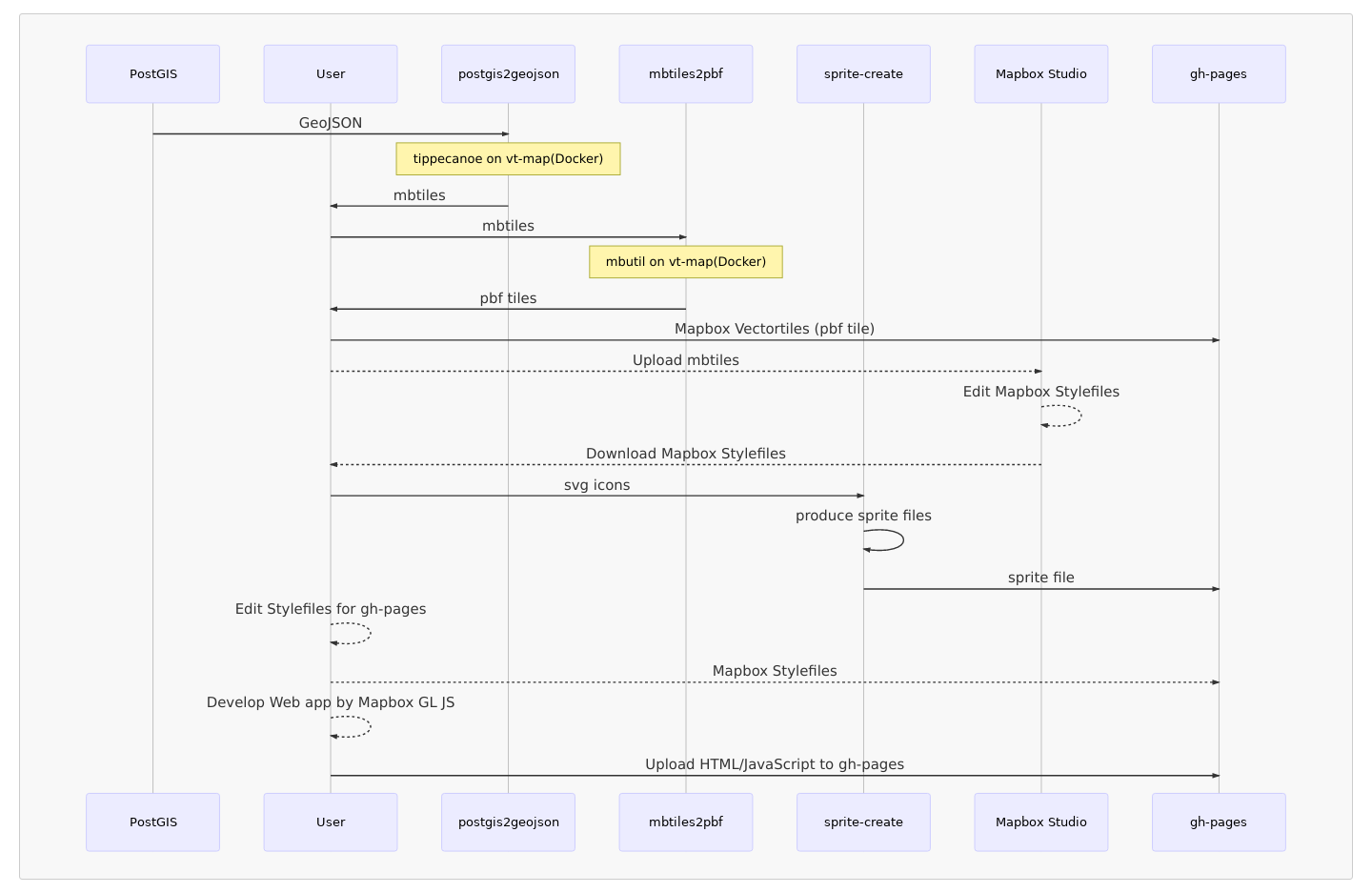
This is awesome implementations of the Mapbox Vector Tile for Narok Water
The procedures of creating vector tile map could be as follows.
- postgis2geojson : This module will create
mbtilesby GeoJSON data which is retrieved fromPostGIS.
First of all, you need to make SQL queries for each layer on config.js, so postgis2geojson tool will extract required data from PostGIS and a mbtiles will be created.
In the current setting, we have prepared following layers for Narok Water and Sewerage Services Co., Ltd.
| Layer | Geometry Type | Min Zoom | Max Zoom | Remarks |
|---|---|---|---|---|
| pipeline | LineString | 10 | 18 | It includes all the types of pipeline, but you may seperate by type of pipe such as main line or secondary line if necessary. |
| meter | Point | 16 | 18 | It only includes household connections. |
| flowmeter | Point | 14 | 18 | It only includes flow meters to cover wider range of zoom level than consumer meters. |
| valve | Point | 15 | 18 | eg. gate valve, sluice valve, air valve, non-return valve, etc. |
| firehydrant | Point | 15 | 18 | It's firehydrant layer |
| washout | Point | 15 | 18 | It's washout layer |
| tank | Polygon | 13 | 18 | Distribution tank layer as Polygon. However, you might need to change geometry type to Point |
| plant | Polygon | 10 | 18 | It incudes boundries of Water Treatment Plant and Water Intake |
| parcels | Polygon | 16 | 18 | It is polygon of parcels data which was provided by Narok town planning office. |
| parcels_annotation | Point | 17 | 18 | We seperated parcel number from other parcel data due to reducing the size of data. |
| village | Polygon | 10 | 17 | Narok water is zoning some area which is called village, you may change layer name for your company. |
| dma | Polygon | 13 | 17 | District Metered Area(DMA) for Non-Revenue Water Management |
| point_annotation | Point | 10 | 18 | We put all the annotation data here if we need to show some label. |
In Narok water, although we have a pumping station at the WTP, we don't have layer for pump. I know it is significant for a water company. So, you may need to add a layer for pumping station.
Next step is to design your own Mapbox Style on Mapbox Studio by using mbtile which was produced before.
You can use our water-icons for the purpose of designing your layers.
You may need to create an account of Mapbox Studio. Then, please keep your public accessToken as well.
You can see official manual of Mapbox Studio here.
-
sprite-create : This module will create sprite file from mapbox/maki icons and water-icons icons. The Spritefiles will be published on gh-pages of this repository.
the following repositories manage our icons which are being used in our style files.
- water-icons : It includes our own customized icon for water assets.
- mapbox-street-icons : It includes icons of Mapbox Street style and customized
water-icons. - mapbox-satellite-icons:It includes icons of Mapbox Satellite style and customized
water-icons.
- vt-map
This module will use the following submodules to create Mapbox Vector Tile for deployment to gh-pages.
- postgis2geojson: It creates
mbtilesfrom PostGIS. - mbtiles2pbf: It converts from
mbtilestopbf(mvt)tiles.
- postgis2geojson: It creates
This module uses tippecanoe for producing mbtiles and uses mbutil to convert mbtiles. However, Narok water's GIS computer is Windows 10 Pro, so it is not easy to run tippecanoe, I developed Docker to create Mapbox Vector Tile.
- mapbox-stylefiles : It manages our Mapbox Stylefiles. Those Stylefiles will be published on gh-pages of this repository.
When you edit your own stylefile, you may download it from Mapbox Studio, then you can delete unnecessary contents from the stylefile, and changed url of vector tile and sprite file on it.
After creating your own stylefiles, you can deploy them to gh-pages.
- mapbox-gl-js-client : It is an web application which is using Mapbox GL JS.
We have already performed the website, so you just edit config.js and build the application. Eventually, deploy it to gh-pages. This is our vector tile application. Let me know if you have some ideas or feedbacks.
I am still thinking how we can automate to update vector tile easily on daily-basis or weekly-basis. Now I think we may create some batch script to deploy them to gh-pages, then we use Windows Task Scheduler to launch it.
Documented by Jin IGARASHI
©Narok Water and Sewerage Services Co.,Ltd.

