Get a dynamically generated and hosted image of a map area from a URL.
- This
http://maps.googleapis.com/maps/api/staticmap?center=New+York+City&size=300x150
- Generates this
<img src="http://maps.googleapis.com/maps/api/staticmap?center=New+York+City&size=300x150"/>In the step after this one, we will be loading the image from within p5.js. In order for this CORS request to not be blocked by Google, we need to authenticate using an API key.
Since this process takes about ~5 minutes to complete, you may use my API key temporarily (Warning: the provided key may not work because only 25,000 map loads may be made per day with this key and you will need to create your own. If you are a teacher, to save time I would recommend creating your own key and sharing that one key with all the students in your class):
AIzaSyCSHUj37EscbQKeCSY4oyM1tCiIgRhEOTE
- Go to https://developers.google.com/maps/documentation/static-maps/
- Click "Get a Key" and follow the directions to create a new key.
- For now, you can use ""
- When you're asked "Accept requests from these HTTP referrers", leave it blank
Just add the parameter &key=YOUR_API_KEY to
your query, like so:
http://maps.googleapis.com/maps/api/staticmap?center=New+York+City&size=300x150&key=AIzaSyCSHUj37EscbQKeCSY4oyM1tCiIgRhEOTE
var mapImage;
function preload() {
mapImage = loadImage("http://maps.googleapis.com/maps/api/staticmap?key=AIzaSyCSHUj37EscbQKeCSY4oyM1tCiIgRhEOTE¢er=New+York+City&size=300x150")
}
function setup() {
createCanvas(400, 200);
background(240, 240, 240);
image(mapImage, 0, 0);
}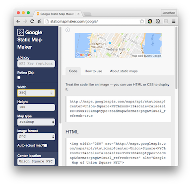
It is an interactive playground for the Google Static Maps API. You can use to play with the parameters.
https://developers.google.com/maps/documentation/static-maps/intro#Usage
Useful Parameters:
zoom
Useful Features:
- Style Maps: you can change the styling of the map to make it look like Pokemon Go (see Pokemon Go Screenshot)
Using Static Map Maker, try the "Add a marker" feature:
Generic Marker
Custom Image Marker

For the remainder of this tutorial, checkout v0-base-template all the way
through v19-mvp-of-battles.
I try my best to walk through a clear step of progressions as to try to explain to the teachers (not student) how the code is constructed. The organization of this project is not good enough for beginning students to follow it.
After building this code up to this point, I recognize now that the later parts of this code is too complicated for beginning students. However it is worthwhile to extract the components that they can learn. APIs used include:
NOTE: Please make sure to open and read all the comments in every file. I didn't have time to move them into this markdown file.
- v1-v6 focus on the Google Maps API and String concatenation
- simple-geolocation-example is meant to introduce geolocation
- v7 is focused on geolocation. Note that for subsequent versions, a fixed geolocation is used instead of using the current user's geolocation.
- v8-v10 focus on using various JavaScript data structures
- v11-15 focus on animating the sprite sprite as well as providing both a mobile and desktop interface
- on the computer
- you can use the WASD arrow keys on the computer
- or click where you want to go
- on your phone
- just touch where you want to go
- on the computer
- v16 focuses on refactoring the code into different functions
- airtable-example introduces a standalone example of creating and updating data in airtable. Make sure you read the notes in
main.js. - v17-18 introduces airtable
- it would be ideal for each student to have their own airtable account
- this airtable database is the best database I could find for JS because:
- there is very good and powerful GUI interface where people who don't even know how to code know how to use it
- the API is custom documented based on your current airtable
- the API itself is simpler than many other APIs
- note that there is a
seed_database.htmlfile which just creates 3 pokemon and puts it in the database. Just open `` - concurrently with the introduction of airtable, in v17, we also move to plotting color swatches and create the sprites on the color swatches. This process might be unnecessarily complex for studnets and resorting to plotting via x/y should be fine...
- this also introduces a new file called pokedex.js. This file was made using import.io and shows a compelling use case of why import.io is useful. See the notes on how I used import.io at the top of this file.
- v19 is an MVP of what a battle scene could look like. I didn't get a chance to actually do the pokeball flicking but it has a modal type change in the game... The code also get a bit sloppy here. I also add audio here.
APIs Used:
- Google Maps API
- import.io (defintely checkout the comments in pokedex.js)
- Airtable as a database
- The HTML5 Audio API