Contributors: hupe13
Tags: leaflet, gpx, geojson, hover, marker
Tested up to: 6.5
Stable tag: 4.2.4.1
Requires at least: 5.5.3
Requires PHP: 7.4
License: GPLv2 or later
This is the Github Version.
Differences to the WordPress version. Releases are the same as the WordPress versions. If you want test the Github version, download from tags.
Extends the WordPress Plugin Leaflet Map with Leaflet Plugins and other functions.
-
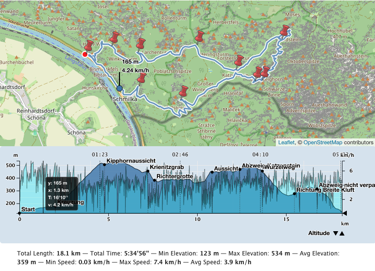
Erstelle ein Höhenprofil eines Tracks. Es gibt ebenso Beschleunigungsdiagramm, Steigungsdiagramm, Geschwindigkeitsdiagramm, Tempodiagramm. Du kannst auch mehrere Tracks auf einer Karte darstellen.
-
Standardmäßig verwendet Leaflet Map die Kacheln von openstreetmap.org bzw. die von dir konfigurierten Kachelserver. Du kannst weitere verwenden und zwischen ihnen umschalten.
-
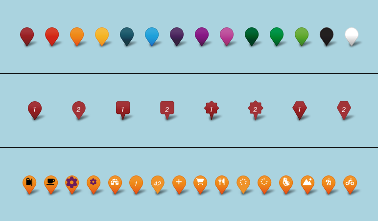
Viele Marker auf einer Karte werden unübersichtlich. Du kannst sie clustern und gestalten.
-
Du kannst Awesome-Markers verwenden.
-
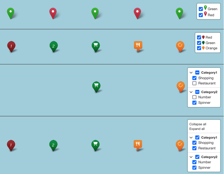
Du kannst Elemente auf der Karte nach Kriterien gruppieren und ein- und ausblenden.
-
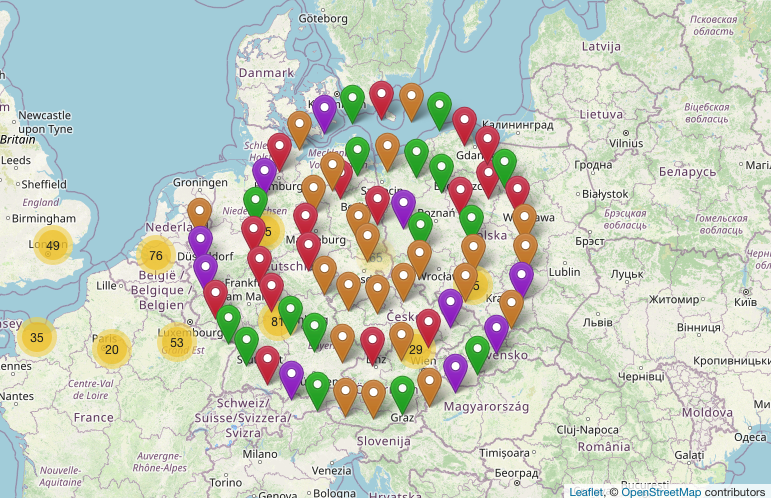
Erstelle eine Übersichtskarte mit den auf den Seiten und Beiträgen hinterlegten Geopositionen.
-
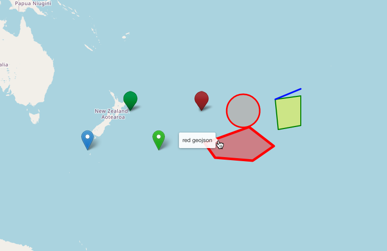
Erhalte einen Tooltip beim Überfahren eines Elementes mit der Maus.
-
Du kannst eine Choropleth-Karte gestalten.
-
Du kannst dir die Karte im Vollbildmodus anzeigen lassen.
-
Setze die Karte zurück.
-
Gestensteuerung.
-
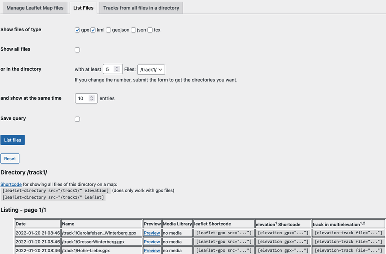
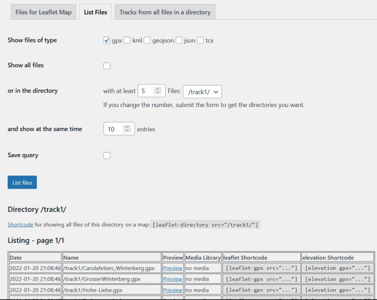
Verwalte deine Dateien für Leaflet Map.
-
Hilfe zum Migrieren von WP GPX Maps.
-
und weitere Funktionen.
-
Create an elevation chart profile of a track. There are also acceleration, slope, speed and tempo chart profiles. You can also place multiple tracks on one map.
-
By default Leaflet Map uses tiles from openstreetmap.org or from the tile servers you configured. You can use more and switch between them.
-
Many markers on a map become confusing. You can cluster and shape them.
-
You can use Awesome markers.
-
You can group the elements on the map by criteria and show/hide them.
-
Create an overview map with geo-locations provided in the pages and posts.
-
Get a tooltip when hovering over an element.
-
You can design a choropleth map.
-
You can display the map in fullscreen mode.
-
Reset the map.
-
Gesture handling
-
Manage your files for Leaflet Map.
-
Help to migrate from WP GPX Maps.
-
and more functions.
- leaflet-elevation: A Leaflet plugin that allows to add elevation profiles using d3js.
- Leaflet.GeometryUtil
- Leaflet.i18n: Internationalisation module for Leaflet plugins.
- leaflet-rotate: A Leaflet plugin that allows to add rotation functionality to map tiles
- Leaflet.AlmostOver: This plugin allows to detect mouse click and overing events on lines, with a tolerance distance.
- @tmcw/togeojson: Convert KML, GPX, and TCX to GeoJSON.
- D3: Data-Driven Documents
- Leaflet-providers: An extension that contains configurations for various tile providers.
- Leaflet.Control.Opacity: Makes multiple tile layers transparent.
- Leaflet.markercluster: Provides Beautiful Animated Marker Clustering functionality.
- Leaflet.MarkerCluster.PlacementStrategies: Styling Markerclusters.
- Leaflet.ExtraMarkers: Shameless copy of Awesome-Markers with more shapes and colors.
- Leaflet.FeatureGroup.SubGroup: Grouping of Leaflet elements by options and features.
- Leaflet Control Search: Search Markers/Features location by option or custom property.
- leaflet-choropleth: Choropleth plugin for Leaflet (color scale based on value).
- leaflet.zoomhome: Provides a zoom control with a "Home" button to reset the view.
- leaflet.fullscreen: Simple plugin for Leaflet that adds fullscreen button to your maps.
- Leaflet.GestureHandling: A Leaflet plugin that allows to prevent default map scroll/touch behaviours.
- turf: Advanced geospatial analysis for browsers and Node.js
- Track with elevation and other profiles and Switching tile layers
- Hover a Geojson area
- Markercluster and Groups
- Markercluster PlacementStrategies
- ExtraMarkers
- Choropleth Map (data from Choropleth plugin example)
- Files for Leaflet Map


Detailed documentation and examples in German and English.
Many thanks to everyone who found errors and provided ideas for new functions.
Is there a widget or other support for the editor?
- Unfortunately both plugins - Leaflet Map and Extensions for Leaflet Map - only work with shortcodes.
- If you have any questions please ask in the forum.
My gpx file is not displayed!
- Is the URL correct?
- Does the webserver return the correct mime type (application/gpx+xml)?
Put in your
.htaccess:
AddType application/gpx+xml gpx
RewriteRule .*\.gpx$ - [L,T=application/gpx+xml]
It doesn't work!
- Are you using any caching plugin? Try to exclude at least these js files from caching:
- /wp-content/plugins/extensions-leaflet-map/leaflet-plugins/leaflet-elevation-*
- /wp-content/plugins/extensions-leaflet-map/leaflet-plugins/leaflet-gesture-handling-*
- Are you using any plugin to comply with the GDPR/DSGVO? There might be a problem with that.
- If you use a caching plugin and a GDPR/DSGVO plugin you need to distinguish whether the user has accepted the cookie or not.
- Please ask in the forum!
Apropos GDPR/DSGVO
- If you need a plugin for this try DSGVO/GDPR Snippet for Extensions for Leaflet Map.
- If you use Complianz | GDPR/CCPA Cookie Consent see here.
- First you need to install and configure the plugin Leaflet Map.
- Then install this plugin.
- Go to Settings - Leaflet Map - Extensions for Leaflet Map and get documentation and settings options.
- Bug in overviewmap (negative lat, lng)