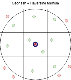
Simple script to learn location based queries with redis.
- Insert location database into redis
wget http://download.geonames.org/export/dump/US.zip
- Begin to query them
- Play with goroutines and channels
Get geohash in resolution you need
Haversine formula is a standard way to calculate distance between 2 points on the surface of a sphere. Earth is not a perfect sphere, so this method may introduce errors of up to .5%. This is usually an acceptable error rate for social proximity searches.
High level process is:
-
Select point
-
retrieve all points within 8 boxes
-
apply haversine formula to results and drop from radius.
-
Redis uses Haversine formula, error rate may be up to 0.5%
-
Add via name, lat, lon Sample data:
4085315 Ragland Cemetery Ragland Cemetery 34.67398 -86.82695 S CMTY US AL 083 0 180 178 America/Chicago 2006
- Get places near me with activities on specific date/range
- Get places near me with activities
