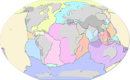
Now with GeoJSON data, courtesy of csterling - Thanks! (note that this data can be previewed directly in the github webinterface)
To get access to the full database, download the zip-archive of all the data (some 5 MB), or clone this repo using your favorite git tool.
The data was downloaded from http://peterbird.name/oldFTP/PB2002/ in June 2014. A copy of the original data is available in the original folder of this repo, with some very minor updates.
This collection is made available under the Open Data Commons Attribution License: http://opendatacommons.org/licenses/by/1.0/, please refer to LICENSE.md for more information. Please consider giving Hugo Ahlenius, Nordpil and Peter Bird credit and recognition as a data source.
All the original data were retrieved from http://peterbird.name/oldFTP/PB2002/ in June 2014 and parsed using Python and Global Mapper 11. Further data manipulation was performed in ArcGIS 10.2. The main edits regarded segments spanning the -180/180 boundary, which had to be manually split and moved.
This work was performed by Hugo Ahlenius, and I am consultant specializing in GIS and cartography, you can read more about me and my services at http://nordpil.com. I wish to extend a warm thanks! to Peter Brid team for creating such a wonderful resource! Also thanks to csterling for preparing GeoJSON format data. Please note anything that can be improved in the data, feel free to contribute, and just let me know if there is anything unclear.
