If you want to see the further ML projects, you may visit my main repo: https://github.com/erdiolmezogullari/ml-projects
Spatial data enrichment: Join two geolocation datasets by using Kdtree
| Problem | Data | Methods | Libs | Link |
|---|---|---|---|---|
Data Enrichment |
Spatial | Kd-tree |
cKDTree |
https://github.com/erdiolmezogullari/ml-join-spatial-data |
In this project, to build an efficient script that finds the closest airport to a given user based on their geolocation and the geolocation of the airport.
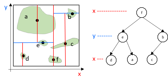
To make that data enrichment, we used Kd-tree algorithm.
The Objective
To build an efficient script that finds the closest airport to a given user based on their geolocation and the geolocation of the airport.
Data-sets
You will be provided with two data sets to consume:
-
optd-sample-20161201.csv.gz- A simplified version of a data set from Open Travel Data, containing geo-coordinates of major airports: -
IATA airport code - a three-character identifier of global airports (first column)
-
Latitude and Longitude in floating point format (second and third columns, respectively)
-
The coordinates represent the location of the airport represented by the IATA code.
-
sample_data.csv.gz- Some sample input data for your script, containing: -
A universally unique identifier (uuid) which identifies some end-user (first column)
-
Latitude and Longitude in floating point format (second and third columns, respectively)
-
For this challenge you need not concern yourself with the precise details of the uuid data and can simply treat it as a unique string key of a fixed format.
All data samples are provided in gzip format for the purposes of efficient data-storage, however it is beyond the scope of this exercise to build gzip decoding/encoding into your script. In other words it is perfectly acceptable for your script to read and write uncompressed csvs.
Input
Your script is expected to parse a csv file in the same format as sample_data.csv.gz described above.
Output
Your script is expected to generate an output csv file containing one line of output for each line of input. The output line is to contain the uuid from the input file and a corresponding IATA code for output. If no match can be found, an empty string should be returned in place of the IATA code.
Task.
Your script will need to do the following. Use of open-source, third-party libraries is highly encouraged:
-
Perform the following basic core functionality:
-
Parse and understand the input csv.
-
Load the airport-geolocation data into either an internal, in-memory data structure or an external in-memory database such as Redis. (HINT: if you do opt for Redis as a solution, the 'Geo' commands could be very helpful to you here!)
-
Geodistance calculation. Take the users's coordinates and compare this with the set of airport coordinates to identify the airport and IATA code with the closest geodistance to the user.
-
Write out the uuid of the user and matching IATA code of the airport.
-
Be capable of performing large batch-jobs efficiently.
-
Be easily adaptable for parallelisation (though you do not need to implement parallelisation for the purposes of this task).
-
Contain decent test coverage.
-
Contain adequate error handling.
-
Include basic documentation.
Deliverables
The purpose of this task is to provide code which satisfies the task above whilst at the same time demonstrating your coding style and engineering skills.
Environment
You have a free hand in choosing the environment in which this code is developed and demonstrated
Languages
Must be in Scala, Java or Python
Licensing
sample_data.csv.gz
The longitude, latitude data in this sample was taken from a data-set provided by Maxmind inc.
This work is licensed under the Creative Commons Attribution-ShareAlike 4.0 International License. To view a copy of this license, visit http://creativecommons.org/licenses/by-sa/4.0/.
This database incorporates GeoNames [http://www.geonames.org] geographical data, which is made available under the Creative Commons Attribution 3.0 License. To view a copy of this license, visit http://www.creativecommons.org/licenses/by/3.0/us/.
optd-sample-20161201.csv.gz
Licensed under Creative Commons - for more information see https://github.com/opentraveldata/optd/blob/trunk/LICENSE
- All other data
All other data in this repository is Copyright travel audience GmbH.