UNIfied COincident Optical and Radar for recognitioN (UNICORN).
- Overview
- Airborne Sensor Hardware
- Coincident Information
- Unicorn 2008 Data Products
- GPS Ground Truth
- Truth/Labels/Tracks
- Bulk Data Access - Amazon S3
- Updates
- Acknowledgments
- Citation
- Copyright information
- Bibliography
The UNICORN 2008 dataset is a multi-modality, partially truthed, simultaneous and coincident dataset, using both a Wide Area Motion Imagery (WAMI) large format electro-optical (EO) sensor, and Wide Area Synthetic Aperture Radar (SAR).
The data was collected over Wright-Patterson Air Force Base using the GOTCHA/NDU radar, and similar sensor to what was used for the CLIF 2007 data collection. The EO data was manually truthed, and GPS ground truth is provided for some targets as well. Targets consist of various cars and trucks, along with radar reflectors. and other calibration targets.
In 2008, the DCS radar was modified to achieve a 5 km diameter spot, while maintaining radar resolution and sensitivity. In August 2008, AFRL performed a data collection with the modified DCS radar along with EO WAMI asset. A fleet of 25 civilian vehicles were deployed at various locations. Finally, a set of 12 large quad-corner reflectors were distributed across the 5 km spot. The location of each stationary vehicle and calibration target was recorded using differential GPS. Over 12 million labels are provided in the WAMI EO data.
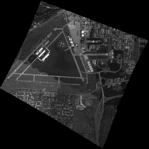
The EO sensor is a large format monochromatic electro-optical sensor comprised of a matrix of six cameras. The cameras, for this data collection, collect data at approximately 2 frames per second. Only geo-projected NITF files are available from this data collection, no raw files were collected.
Sample Image:
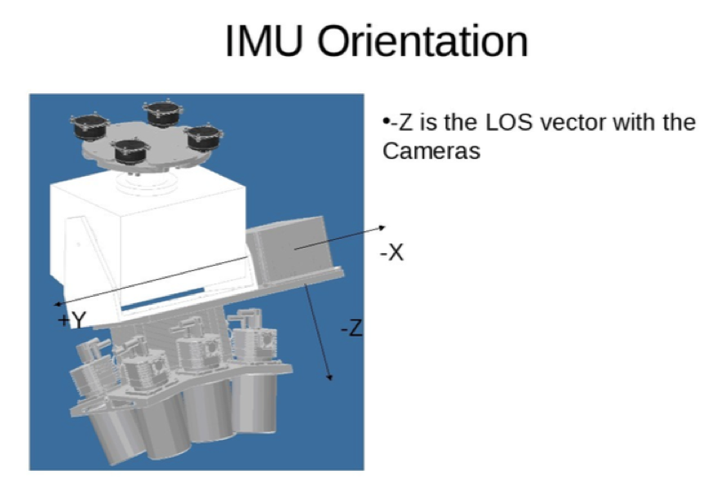
Each camera was made by Illunis employing a Kodak KAI-11002 charge coupled device (CCD). The optics are Canon 135 MM EF mount lens controlled with a Birger adapter. Unfortunately both the CCD and camera have been discontinued. On the rear of the camera head was a Novatel DL4 Plus SPAN with a Honeywell HG1700_AG11 inertial measurement unit (IMU). The entire integrated system is shown below.
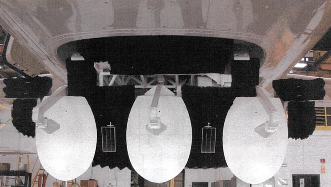
The Gotcha/NDU Antenna Set consists of the Standard NDU antenna set (three white dual-polarized parabolic dish antennas) plus two Trifurcated Horn antennas mounted between the center and outer NDU antennas. the antennas are cabled/plubmed to the radar to allow Gotcha operation (5km swath HH polarization through the horn antennas) and NDU multi-phase center (~1 KM swath H and V polarization) operation on a pass-by-pass basis.
All the data in question was collected on 2008-08-16.
The SAR NITFs go from 14:33:02 UTC to 15:16:55 UTC. The EO NITFs go from 14:41:40 UTC to 16:36:14 UTC.
Therefore, we have data for both sensors from 14:41:40 UTC to 15:16:55 UTC.
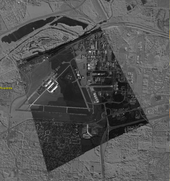
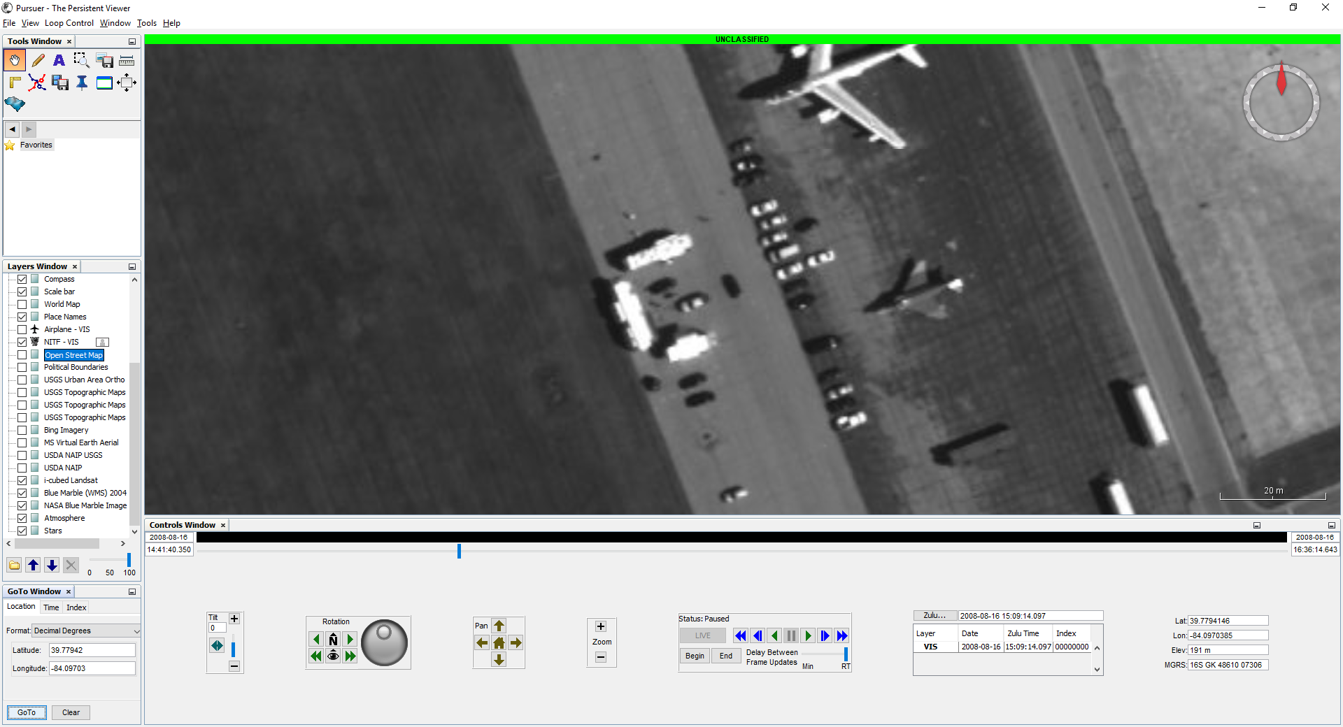
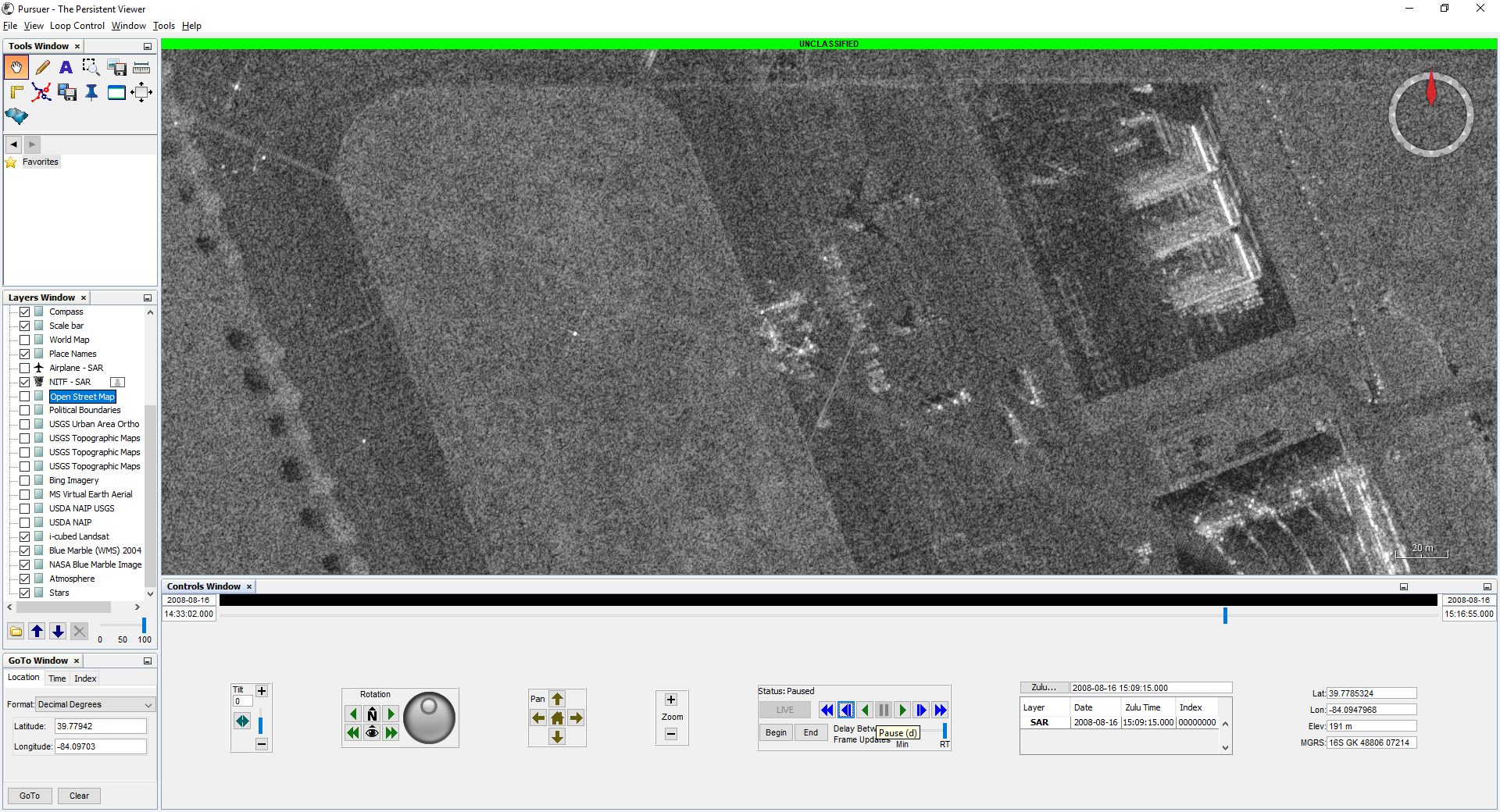
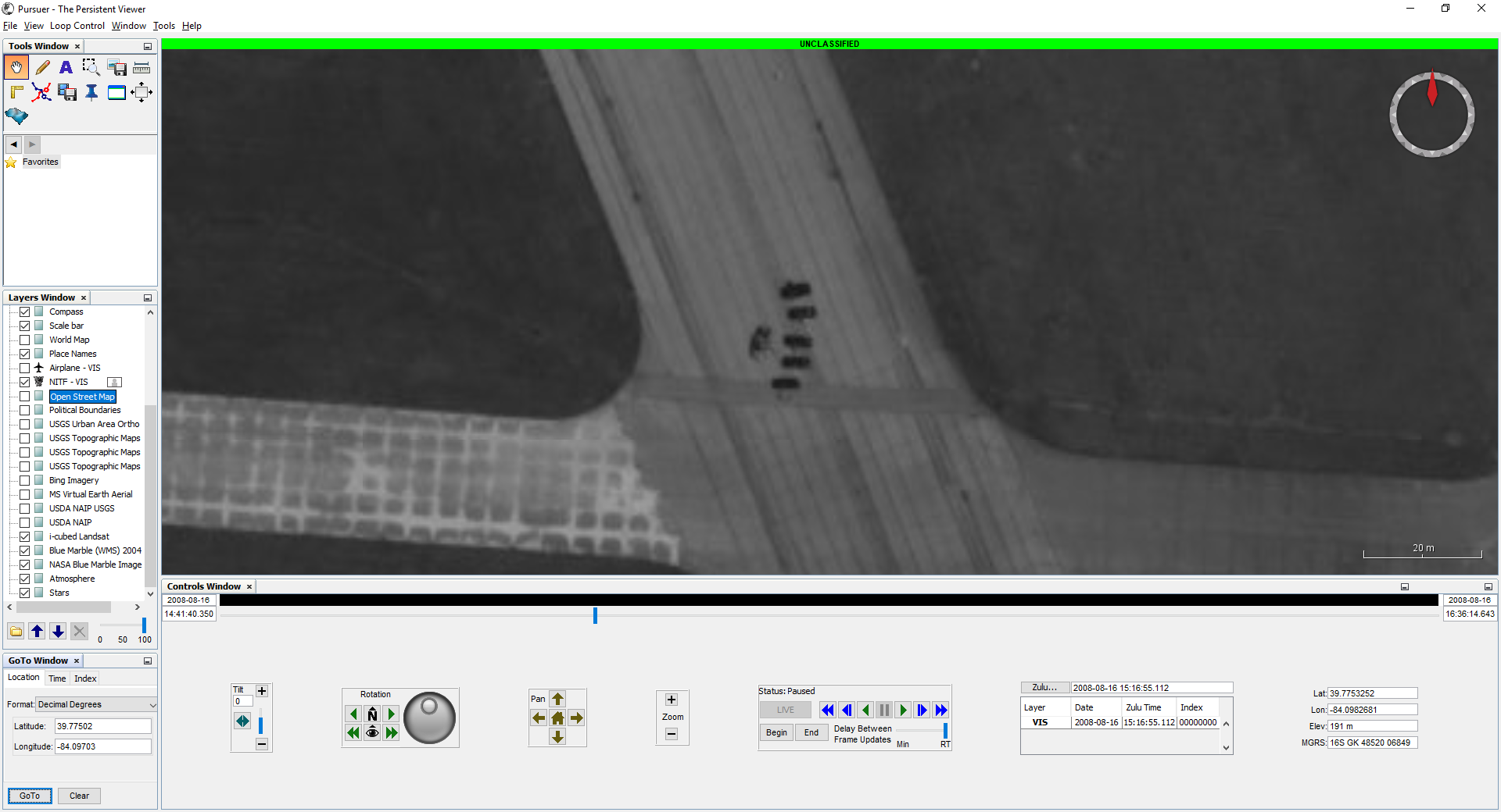
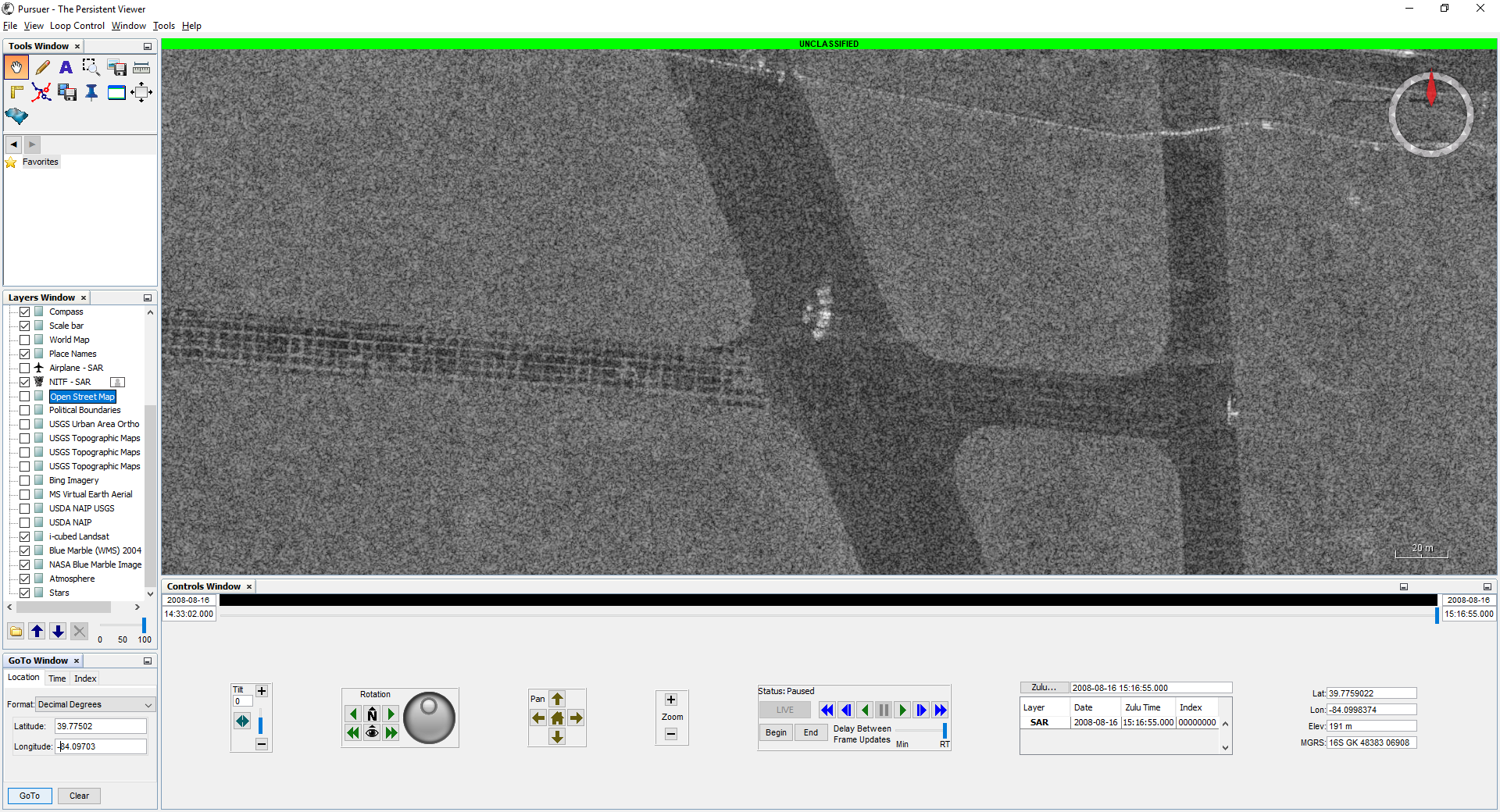
The EO coverage moves around quite a bit, but seems centered on the southeast corner of the Wright-Patterson Air Force Base Area B runway triangle. The SAR coverage forms a square, steady swath, exactly 5kmX5km, apparently also centered on the southeast corner of the runway. Targets near the corner at 39.7760017, -84.0976938 should be visible in both modalities.
This was confirmed by inspecting via Pursuer:
EO/SAR images of Nissan Altima at ground station:
EO/SAR images of Nissan Altima on runway:
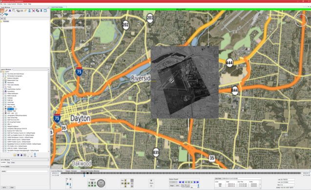
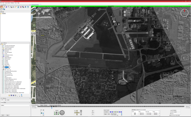
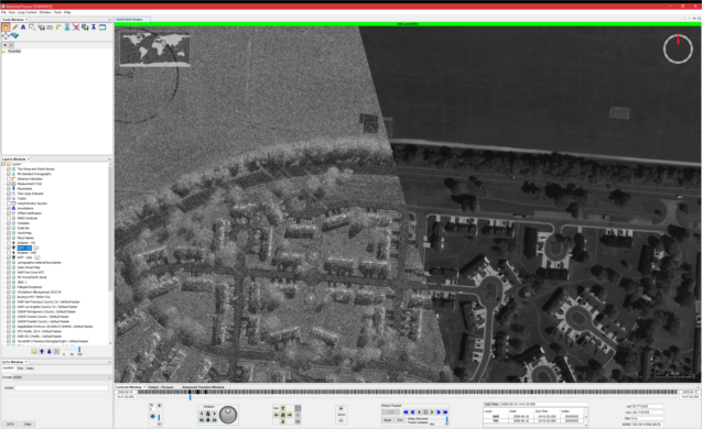
Viewing remote sensing data with a high update rate can be a challenge additionally the UNICORN data set has two sensor streams, a remote sensing viewer that can visualziae both sensor streams of the UNICORN data with considertation for temporal aspects is Pursuer version 2.4. Pursuer is available at the FOUO DIST C level.
EO/SAR overlaid together in Pursuer click for full resolution:
EO/SAR overlaid together in Pursuer higher resolution click for full resolution:
EO/SAR overlaid together in Pursuer highest resolution click for full resolution:
- EO NITF Image data, (~70 GB).
- SAR NITF Image data (300+ GB), formed with backprojection.
- Ground Truth using GPS
- WAMMIT Truth database for EO data
National Image Transmission Format (NITF) is the DoD standard for imagery. Bascially a NITF file is a large header with the data concatenated onto the rear of the file. The data or image is stored in blocks of jpeg 6.2 compressed images of 128 x 128 size. The easiest way to read NITF data is to use Geospatial Data Abstraction Layer (GDAL). Example Python code is provided code/NITFPythonGDAL.py that will read the NITF file then plot the image in a matplotlib plot.
The NITF files are named as "YYYYMMDDHHMMSS-FNXXXXXX-VIS.ntf.r0", where FN is the flight number and XXXXXX is the frame number, an example file name is "20071028142730-01000324-VIS.ntf.r0". On close inspection of the NITF data you will notice that each of the NITF files have six correpsonding files each with r0, r1, r2, r3, r4, and r5. Those files represent the resolution set also known as the r set. The highest resolution is r0 while the lowest resolution is r5.
The NITF files are stored in standard "tarballs" in Amazon S3 requester pay buckets at s3://sdms-unicorm-2008. See the bulk data access section at the end of mark down file for instructions on how to download the NITF imagery.
GPS ground truth is provided for 11 targets that were present on the day of the data collection:
- 1992 Chevy Blazer
- 2000 Dodge Durango
- 2001 F150 SuperCrew Pick Up Truck
- 2000 Ford Windstar
- 2002 Honda Accord
- 2005 Hyundai Sonata
- "Kidnap Dismount"
- 2004 Yamaha XVS 650 Motorcycle
- 2007 Nissan Altima
- 2007 Saturn Ion
- 2002 Subaru Station Wagon
For each target a single comma sperated value (CSV) with the first line containing description of the fields is provided. These labels are provided in the data set and stored in s3://sdms-unicorn-2008/20080816_UNICORN_GPS_Ground_Truth.zip. Example GPS Ground Truth Data is provided below:
Status, Latitude(DecDegrees), RefrncDirctn, Longitude(DecDegrees), RefrncDirctn, TimeUTC(hhmmss), Date(ddmmyy), Speed(mph), Heading(True), AltitudeMSL(ft), HDOP, Satellites, ,SatusA= ,valid_data ,GPS_ok
4,39.78656206,N,84.10331385,W,140009,160808,0.003163506,84.62161,792.1587927,1.23,7,,,,
4,39.78656204,N,84.10331384,W,140010,160808,0.005001942,84.63015,792.1358268,1.23,7,,,,
4,39.78656205,N,84.10331385,W,140011,160808,0.002236936,84.68801,792.1489501,1.23,7,,,,A variety of objects in the scene were tracked and truthed (or labeled) by humans. These labels are provided in the data set and stored in s3://sdms-unicorn-2008/20080816_UNICORN_truth.zip. The truth data was generated with AFRL Sensor Directorate's WAMITT tool and is provided in a MySQL dump text file. The relational database structure is shown in WAMITT relational DB design. Truth or labels were derived from the NITF EO files.
Sqlite3 is easier to work with for some users because sqlite3 does not require a server install of the MySQL database. To convert from MySQL dump sql file format to sqlite3 see the script on github. The labels in sqlite3 database format are stored s3://sdms-unicorn-2008/20080816_UNICORN_truth_sqlite3.zip. An example command to convert the WAMITT tracks is:
./mmysql2sqlite wamitt_gotcha_v01.sql | sqlite3 wamitt_gotcha_v01.db
./mmysql2sqlite wamitt_gotcha_v02.sql | sqlite3 wamitt_gotcha_v02.db
./mmysql2sqlite wamitt_gotcha_v03.sql | sqlite3 wamitt_gotcha_v03.db
./mmysql2sqlite wamitt_gotcha_v04.sql | sqlite3 wamitt_gotcha_v04.db
./mmysql2sqlite wamitt_gotcha_v05.sql | sqlite3 wamitt_gotcha_v05.dbIn addition to the MySQL data dump file we have taken the liberty to convert the file into a single comma separated value (CSV) file to ease processing of the truth file. The CSV file is stored here s3://sdms-unicorn-2008/20080816_UNICORN_truth_csv.zip. The script code/convert_sqlite3_truth_csv.py was used to convert the SQLite3 database to CSV. It is an easily modifiable script in case your research requires additional fields. The CSV file includes the field names on the first line of the file. A snippet of the CSV file is included below:
track_point.fileId,track_point.time,track_point.frame,track.id,track_point.id,target_type.name,color.color,track.length,track.width,track_point.x,track_point.y,track_point.latitude,track_point.longitude
NITFVIS2008081614414001004700,1218897700350,4700,7743,15924061,SUV,gray,4.82,1.77,9216,2935,39.7844829464586,-84.0886010810624
NITFVIS2008081614414001004701,1218897700790,4701,7743,15924071,SUV,gray,4.82,1.77,9224,2933,39.7844914764619,-84.0885647941102
NITFVIS2008081614414101004702,1218897701310,4702,7743,15924075,SUV,gray,4.82,1.77,9133,3035,39.7844956265658,-84.0885370489355
NITFVIS2008081614414101004703,1218897701840,4703,7743,15924076,SUV,gray,4.82,1.77,9048,2875,39.7845246616604,-84.088486115833The Python code code/truth_stats.py was used to generate the statistics for the truth/label data below.
- Total number of images with truth data: 6,471
- Total count of objects truthed: 12,766,950
- The count of each object type
- SUV: 1,248,213
- SUV w/trailer: 19,445
- bicycle: 936
- boat: 236
- box truck: 88,486
- bus: 38,243
- dismount: 6,627
- dump truck: 2,398
- flatbed truck: 20,880
- flatbed truck w/trailer: 4,697
- motorcycle: 55,122
- other: 113,271
- pickup truck: 589,348
- pickup truck w/trailer: 35,163
- plane: 19,269
- sedan: 9,912,570
- sedan w/trailer: 15,300
- semi: 21,270
- semi w/trailer: 40,085
- van: 531,646
- van w/trailer: 3,745
- The count of each object type
Due to the difficulties with tracking moving objects in SAR a large amount of parked vehicles was truthed in the UNICORN data set.
The list of static objects includes a map plus static object list of reflectors that reflect EM energy which can be easily spotted in the RADAR data.
The UNICORN 2008 data is available from Amazon Simple Storage Service (S3) in Requester Pays buckets (i.e., you are charged by Amazon to access, browse, and download this data). Please see Requester Pays Buckets in the Amazon S3 Guide for more information on this service. Your use of Amazon S3 is subject to Amazon's Terms of Use. The accessibility of SDMS data from Amazon S3 is provided "as is" without warranty of any kind, expressed or implied, including, but not limited to, the implied warranties of merchantability and fitness for a particular use. Please do not contact SDMS for assistance with Amazon services, you can post a GitHub issue and the authors will try and assist.
The name of the S3 bucket is s3://sdms-unicorn-2008/
We do not track development of tools interacting with Amazon S3, nor endorse any particular tool. However, in development of this facility we found the Python package s3cmd to be useful on Mac OS X and Linux. For Windows the AWS team provided the following suggestions s3browser.com and cross ftp.
The examples shown below were developed and tested with Linux and Mac OS X using the Python distribution of Enthought Canopy. First you must establish a AWS account and download your AWS_ACCESS_KEY_ID and AWS_SECRET_ACCESS_KEY. Next use the following commands to export your key id and secret access key to the shell environment replacing the values of AWS_ACCESS_KEY_ID and AWS_SECRET_ACCESS_KEY with the values from your newly established AWS account:
export AWS_ACCESS_KEY_ID="JSHSHEUESKSK65"
export AWS_SECRET_ACCESS_KEY="kskjskjsAEERERERlslkhdjhhrhkjdASKJSKJS666789"
Install s3cmd with pip:
pip install s3cmdTo list the directory of the sdms-unicorn-2008 bucket use the following command:
s3cmd --requester-pays ls s3://sdms-unicorn-2008/Please note all the UNICORM 2008 data products are in a single directory.
To determine the amount of disk space in the sdms-unicorn-2008 bucket use the command:
s3cmd --requester-pays --recursive --human du s3://sdms-unicorn-2008/To retrieve a file:
s3cmd --requester-pays get s3://sdms-unicorn-2008/truth/20080816_UNICORN_GPS_Ground_Truth.zipWe do not recommend that you use s3cmd sync capability because the number of files and size of the UNICORN data set is large and errors will result.
The UNICORN 2008 data set is large at approximately 394 GB, to download the entire data set it would cost $35.46. This assumes AWS download fees are $0.09 a gigabyte.
This does not include the raw SAR phase history, which is in the range of ~4TB. Downloading this would cost ~$360.
If you wish to acquire the raw phase history, please create an issue.
Most researchers will not require the entire UNICORN 2008 data set, carefully consider the data that you require to meet your research needs and download costs. We have divided the dataset into small tarballs to make the download easier and to make it possible for a researcher to select the data they need. For instance raw images can be downloaded by camera number and NITF files can be downloaded by flight number. Much smaller index files have been provided that lists the file name and size of each file contained in the tarballs. We attempted to maintain a careful balance between tarball size and number of tarball files. Obviously the smaller the tarball file the more tarball files that would have to be created.
Please feel free to create a pull request or new issue if you write a paper that uses this data set so we can update the bibliography. In addition we will gladly accept pull requests and new issues for corrections or bug fixes.
Todd Rovito and Olga Mendoza-Schrock were supported under an AFOSR grant in Dynamic Data Driven Application Systems.
When reporting results that use the Unicorn 2008 dataset, please cite:
Colin Leong2, Todd Rovito1, Olga Mendoza-Schrock1, Jason Bowser2, Linda Moore1, Steve Scarborough1, Michael Minardi3, David Hascher4. Unified Coincident Optical and Radar for Recognition (UNICORN) 2008 Dataset. https://github.com/AFRL-RY/data-unicorn-2008, 2019
- AFRL/Sensors Directorate/RYA 2241 Avionics Circle, Wright-Patterson AFB, Ohio 45433
- University of Dayton Research Institute (UDRI), 300 College Park, Dayton, Ohio 45469
- Matrix Research Inc 1300 Research Park Dr, Beavercreek, Ohio 45432
- Applied Research Solutions 51 Plum St. Suite 240 Bevercreek, Ohio 45440
This page and data set is in the public domain under 17 U.S.C. 105.
