geohub
What is GeoHub?
GeoHub is -- in fancy terms -- a framework for real time geographic applications. It currently allows for
- Ingesting geographic points, for example GPS positions, via HTTP API.
- Exporting geographic points as GeoJSON (GPX soon to come).
- Efficiently listening to position updates (new points) in real time via HTTP API.
- Privacy first by protecting every point with a password (session token).
API description
Important concepts are:
- A Client is for example someone walking around with their phone, or a
moving car. A client sends geographic updates to the server. The
clientappears as URL component after/geo/. - A Secret is an alphanumeric string (a-zA-Z0-9 only) attached to every
point. Anyone wanting to retrieve a given point needs to know its secret. You
can also log points without secret. In that case, everyone can see them
(including clients asking for points with a secret). The
secretis supplied as URL parameter&secret=. - Every point has a unique integer ID. It can be used to limit which points to fetch, for example when refreshing or waiting on updates. Think of it as a very fine-grained page token.
Scenario: You go for a walk, configuring your phone to send live updates to a
GeoHub instance. You want to share it with a friend who is not supposed to know
about where you were yesterday. You can leave your client string the same and
use a new secret that you give to your friend; they can now only see points
logged with this secret.
POST/geo/<client>/log?lat=<latitude>&longitude=<longitude>&time=<time>&s=<speed>&ele=<elevation>&secret=<secret>- Log a new point.
client,secret: See above.latitude,longitude: Geographical position, in decimal degrees (note: may be extended later). Required.time: ISO 8601 time. If left out, current server time is used. Example:2020-12-03T15:42:40.010325Z. Optional.speed: Speed in km/h (usually). If you decide to always use m/s, you are free to do so. Optional.elevation: Elevation in meters. Optional.accuracy: Accuracy in meters. Optionalunit: If given, convert the number given for&s=intokm/hfor storage, assuming the given unit. Can be: kn/knots, mph, mps/ms/'m/s', kmh/'km/h'/kph.datesecret: Iftrue, automatically set the secret toYYYYmmdd(e.g.20210405). Useful if you want daily tracks with different secrets, but don't care about actual secrecy. Based on the sent time or UTC if no time was sent.- A body -- if present and encoded in whatever content-type -- is attached as
noteto the point and returned as propertynoteof GeoJSON points later. - Usually returns code 200 except for server errors (500) or malformed inputs (400).
POST/geo/<client>/logjson?secret=<secret>with body:application/json.- Log one or more new points.
clientandsecrethave the semantics described above.datesecret: Iftrue, automatically set the secret toYYYYmmdd(e.g.20210405). Useful if you want daily tracks with different secrets, but don't care about actual secrecy. Based on UTC.- The body is expected to be a JSON document structured like the following
example -- a single field
locationscontaining a list of GeoJSONFeatures.
{
  "locations": [
  {
    "type": "Feature",
      "geometry": {
        "type": "Point",
        "coordinates": [
          -122.030581,
        37.331800
        ]
      },
      "properties": {
        "timestamp": "2015-10-01T08:00:00-0700",
        "altitude": 0,
        "speed": 4,
        "horizontal_accuracy": 30,
      }
  },
  ]
}GET/geo/assets/...- Static file serving. The
assetsdirectory should be deployed in the current working directory from which the server is run.
- Static file serving. The
GET/geo/<client>/retrieve/json?secret=<secret>&from=<from_timestamp>&to=<to_timestamp>&limit=<maximum number of entries returned>&last=<id of last known entry>- Fetch geo data as GeoJSON object. Returns oldest point first within the
returned
GeoJSONobject. from,to: Timestamp range. For best results, supply ISO 8601 timestamps, butYYYY-mm-dd hh:mm:ss.sssis also accepted. (GeoHub tries to be flexible about this, and may become better over time).limit: Return at most this number of entries, starting with the oldest entries.last: This is a sort of page token, identifying the most recent entry you know. GeoHub will only return events newer than this. The IDs used here are returned as propertyidin the GeoJSONFeatures.- Returns a GeoJSON object.
- Fetch geo data as GeoJSON object. Returns oldest point first within the
returned
GET/geo/<client>/retrieve/gpx?secret=<secret>&from=<from_timestamp>&to=<to_timestamp>&limit=<maximum number of entries returned>&last=<id of last known entry>- Fetch geo data as GPX document (
application/gpx+xml). - This endpoint has the same parameters as the
retrieve/jsonendpoint. It returns a GPX document containing one Track consisting of one Track Segment. The GPX version is 1.0.
- Fetch geo data as GPX document (
GET/geo/<client>/retrieve/last?secret=<secret>&last=<last ID>&limit=<max entries>- Fetch most recent points for the
client. See/geo/<client>/retrieve/jsonabove for descriptions of the other parameters. As opposed toretrieve/json, the returned points are guaranteed to be ordered by time with the newest point first (as makes sense for some use cases), and wrapped inside aGeoHubUpdateobject containing additional information. This makes the returned value identically structured to that ofretrieve/livebelow. - Returns a
LiveUpdateobject.lastis the most-recent ID of all points:
- Fetch most recent points for the
{
  "type": "GeoHubUpdate",
  "last": 1205,
  "error": "error string if applicable",
  "geo": {
    "type": "FeatureCollection",
    "features": [
      {
        "type": "Feature",
        "properties": {
          "time": "2020-12-03T15:42:40.010325Z",
          "altitude": 40,
          "speed": 22,
          "id": 1205,
          "accuracy": 12.5,
          "note": "A happy little note",
        },
        "geometry": {
          "type": "Point",
          "coordinates": [
            6.09,
            50.795
          ]
        }
      },
    ...
    ]
  }
}GET/geo/<client>/retrieve/live?secret=<secret>&timeout=<timeout in sec>- Wait at most
timeoutseconds for events fromclientwith the givensecret. This is a "hanging" request endpoint, returning aftertimeoutseconds or any time that a new point has been logged. This is useful for real-time applications, such as the live map (inassets/). - This API returns data compatible with
/geo/<client>/retrieve/last. Think of the two endpoints as complementary, one retrieving recent and this one returning current events. - Note: As opposed to other endpoints, this endpoint doesn't return points with lacking secret ("public" points).
- This endpoint returns at most one point at a time.
- If no new point has arrived in time, a
LiveUpdatewithnullentries forgeoandlastis returned.
- Wait at most
Installation
Installing GeoHub is quite easy. You need
- a PostgreSQL server
- (optional) a reverse proxy in front
- Set up a database with the supplied
pgsql_schema.sql. It will install the elements into thegeohubschema. Currently, this is a very small schema. Make sure that thepgcryptoextension is enabled in your database.PostGISis not required. - Configure the database connection in
Rocket.toml. Rocket.rs usually connects to PostgreSQL via localhost/::1, so make sure that this is allowed by modifyingpg_hba.confif needed. - If you want TLS or already have a server on port 80/443, configure your main webserver to proxy to GeoHub. For example, in nginx you can achieve this very easily:
# Put this in an existing server { } block.

    # Geohub
    #
    # This will strip the /geo/ prefix, so add it back below. Adapt to your
    # preferred URL scheme.
    location /geo/ {
        proxy_pass http://127.0.0.1:8000/geo/;
    }
Finally, make a copy of Rocket.toml.example to Rocket.toml, adapt for your
needs, and run cargo run --release.
Usage
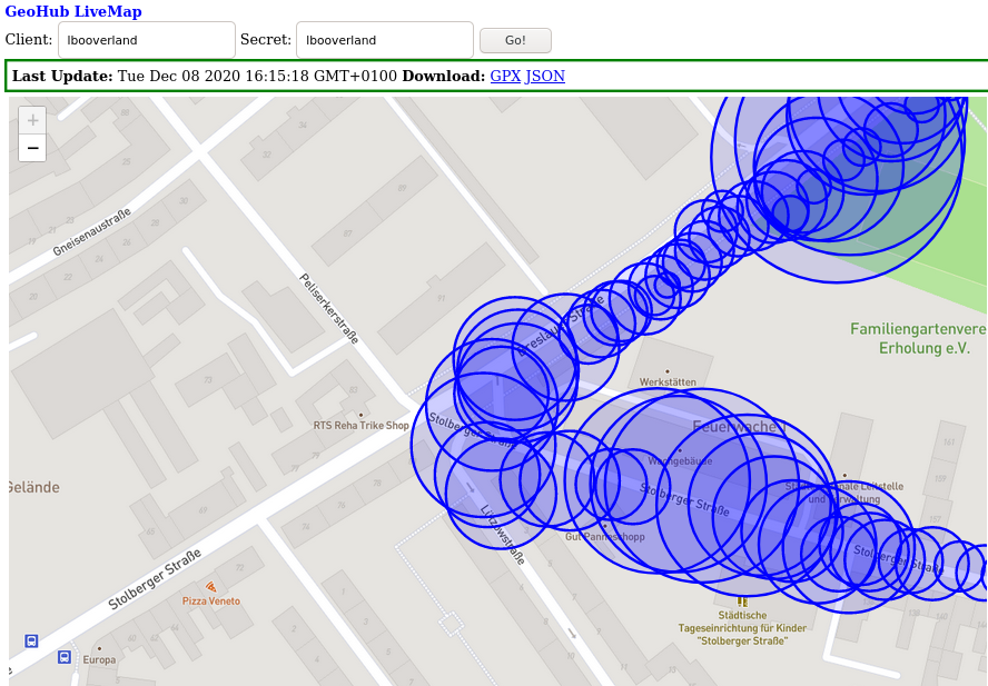
 Map data © OpenStreetMap contributors, CC-BY-SA, Imagery © MapBox
The assets/ directory contains web applications directly built on top of
GeoHub with nothing more than Ajax and some third-party libraries.
This also allows you to immediately use the livemap app at
https://yourhost.com/geo/assets/livemap.html, which consists of a single HTML
page, a CSS file, and the leaflet.js library (which is included). - latter is
(c) 2010-2019 Vladimir Agafonkin, (c) 2010-2011 CloudMade.
It displays live location data as it is ingested, in real time.
Ingestion
From Android phones
If you want to go on a difficult hike (though one with nice mobile data coverage) and keep your worried parents up to date, do this:
- Install the
GPSLoggerapp. It is one of only few apps I know of that has the features required to work with GeoHub. - Configure the Custom URL feature to your URL. By default, you only
(optionally) need to add a secret and of course your host and URL part. See
the API documentation above: GPSLogger works with the
/geo/<client>/logendpoint. - Start logging, and pass the appropriate link to the livemap
(
https://yourhost.com/geo/assets/livemap.html?client=<yourclient>&secret=verysecret) to any concerned relatives. If you configure GPSLogger to log every few seconds, it will work best. Latency between a point reaching your server and the live map being updated will generally be way less than half a second.
See also the examples/ directory for more ways to use GeoHub. For example,
stream metadata from German long distance trains to GeoHub.
Alternatively, Overland (iOS,
Android) is also able to send
data to GeoHub. As it uses a different API, use a URL like
https://yourhost.com/geo/<yourclient>/logjson?secret=<yoursecret>. This is the
batch API, as Overland sends batches of points.
From the web
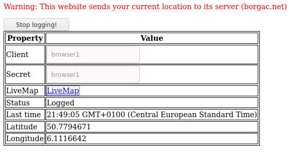
The TrackMe "UI", allowing ingestion of browser-supplied location from any device running a web browser.
The assets/trackme.html site contains a simple script to regularly send your
browser location (only when changed) to the GeoHub instance serving it.
If your GeoHub is running, you can simply use it by going to
https://your.geohub.com/geo/assets/trackme.html?client=YOURCLIENT&secret=YOURSECRET.
Click the start button to start sending locations to GeoHub. Of course the browser will ask for permission before allowing access to you location.
