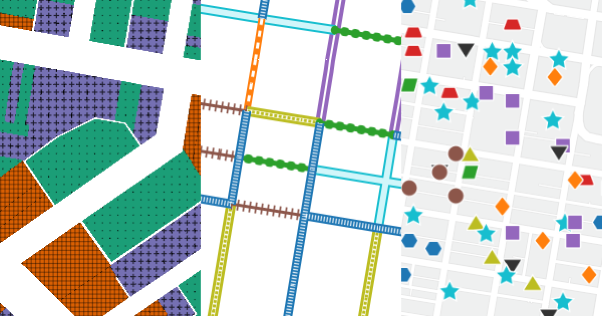
Textures, patterns, and shapes that make web maps work for people with color vision deficiency. Built for Mapbox GL and MapLibre GL.
TextureMap polygons use the Mapbox fill-pattern property to add a pattern layer to the map. If your polygon style includes color and pattern, each of those properties will be handled by a separate layer. In other words, you will have one layer for fill-color beneath a second layer for fill-pattern. If you want to allow your user to toggle the pattern on and off, you can set the visibility to none for the pattern layer.
- Open a project in Mapbox Studio
- Open the "Images" tab from header
- Switch to the "Custom" tab
- Upload images from
dist/polygons - Create or edit a fill (polygons) or symbol (points) layer
- Set the "Pattern" property to an image from TextureMap
If you are working directly with the Mapbox GL or MapLibre libraries, you will need the TextureMap images as a sprite. You can download these from dist/sprites or generate them yourself using spritezero. See examples/points for an example project using a sprite.
TextureMap lines are trickier to implement than the other geometry types. To achieve unique line styles, TextureMap builds compound lines using several overlapping lines. For example, the "railroad style" lines -|-|-|- are constructed from 1.) a thin line as the base; 2.) a thick line with a dash array for the perpendicular lines.
Here is what the Mapbox style definition looks like for the example described above:
// Thin base line
{
  id: "line7-a",
  type: "line",
  source: "lines",
  filter: ["match", ["get", "type"], 7, true, false],
  layout: { "line-miter-limit": 0 },
  paint: { "line-color": "#8c564b", "line-width": 3 }
}
// Thick line with dash array for the perpendicular lines
{
  id: "line7-b",
  type: "line",
  source: "lines",
  filter: ["match", ["get", "type"], 7, true, false],
  layout: { "line-miter-limit": 0 },
  paint: {
    "line-color": "#8c564b",
    "line-dasharray": [0.15, 0.4],
    "line-width": 11
  }
}
See examples/lines/js/main.js for a full list of the line styles used in TextureMap.
TextureMap points use the Mapbox icon-image property on a symbol layer.
- Open a project in Mapbox Studio
- Open the "Images" tab from header
- Switch to the "Custom" tab
- Upload images from
dist/points - Create or edit a symbol layer
- Under the "Icon" tab, set the "Image" property to a image from TextureMap
If you are working directly with the Mapbox GL or MapLibre libraries, you will need the TextureMap images as a sprite. You can download these from dist/sprites or generate them yourself using spritezero. See examples/points for an example project using a sprite.
TextureMap is designed for categorical data. Examples of categorical data would be types of schools (public, private, charter) and political party representation (Democratic, Republican). Use "colorblind safe" color schemes for sequential and diverging data.
To the extent possible, use shapes that are visually distinct. Good: a circle, triangle, and square look relatively different. Bad: a pentagon, hexagon, and octagon look relatively similar.
If you are not colorblind (color vision deficient), use simulation tools such as Sim Daltonism to test your designs. Consider hiring a consultant to review your work.
TextureMap can work well as a default style or as a toggleable setting.
TextureMap can improve accessibility for colorblind users. But even the best designed map can be an accessibility nightmare for screen reader users, users who don't use a mouse, etc. For a truly accessible experience, provide an alternative to maps. Offer data as tables, lists, and text. Design workflows that don’t depend on a map to get to the next step. Ask: if the map disappeared, could a user complete their task?
- Robert Noorda for colorblind consulting
- Scott Lederer for feedback on initial concept and website
- Alex Lash for feedback on initial concept and website
