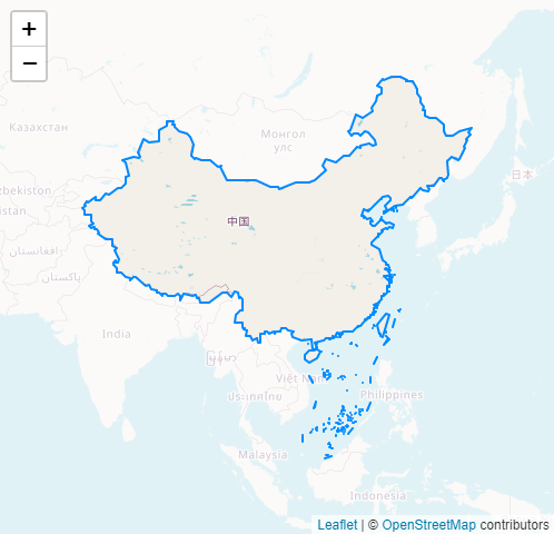
Leaflet.Mask is a Leaflet plugin that loading polygons from geojson to masking the rest of the map.
Check out the demo.

var map = L.map("map", {
center: [29, 120],
zoom: 8
});
L.tileLayer('https://{s}.tile.openstreetmap.org/{z}/{x}/{y}.png', {
attribution: '© <a href="https://www.openstreetmap.org/copyright">OpenStreetMap</a> contributors'
}).addTo(map);
L.mask('bound.json', {}).addTo(map);L.mask(geosjon, options?)
| Parameter |
Type |
Description |
| geosjon |
String|Object |
.geojson URL or GeoJSON object |
| options |
Object |
Layer options |
| Option |
Type |
Default |
Description |
| interactive |
Boolean |
false |
If false, the mask layer will not emit mouse events and will act as a part of the underlying map. |
| fitBounds |
Boolean |
true |
If true, the map fits the maximum zoom level to the given geographical bounds. |
| restrictBounds |
Boolean |
true |
If true, the map restricts the view to the given geographical bounds, bouncing the user back if the user tries to pan outside the view. |
Options inherited from L.Path
| Option |
Type |
Default |
Description |
| stroke |
Boolean |
true |
Whether to draw stroke along the path. Set it to false to disable borders on polygons or circles. |
| color |
String |
'#3388ff' |
Stroke color |
| weight |
Number |
2 |
Stroke width in pixels |
| opacity |
Number |
1.0 |
Stroke opacity |
| lineCap |
String |
'round' |
A string that defines shape to be used at the end of the stroke. |
| lineJoin |
String |
'round' |
A string that defines shape to be used at the corners of the stroke. |
| dashArray |
String |
null |
A string that defines the stroke dash pattern. Doesn't work on Canvas-powered layers in some old browsers. |
| dashOffset |
String |
null |
A string that defines the distance into the dash pattern to start the dash. Doesn't work on Canvas-powered layers in some old browsers. |
| fill |
Boolean |
depends |
Whether to fill the path with color. Set it to false to disable filling on polygons or circles. |
| fillColor |
String |
'#FFFFFF' |
Fill color. |
| fillOpacity |
Number |
1.0 |
Fill opacity. |
| fillRule |
String |
'evenodd' |
A string that defines how the inside of a shape is determined. |