This is sort of my personal swift playground - nothing special.
I'll be working on a simplistic city simulation implemented in swift. This repository is intended to represent only the simulation data and logic, no UI.
CitySimCore is shipped as framework for iOS and macOS.
The following describes the underlying data structure the simulation uses.
This section is also meant to elaborate on and describe specific terms related to the data structure.
The simulation uses a 2-dimensional representation of a map.
The "City" is composed of a multi-layerd map (see CityMap) and multiple statistical information.
Statistical information that doesn't apply to the map is represented in attributes of the City object, such as:
- Budget: current budget and ongoing cost
- Ressources: current supply and demand for ressources
- Population: current population count
The map is composed of multiple "layers", each holding information regarding a different aspects of the map, for example:
- tiles (actual game objects)
- graph (graph nodes for pathfinding)
- Air Pollution (statistic data)
- Noise (statistic data)
- Land Value (statistic data)
see Layer
A single address (1x1) on a layer is called a "cell".
There are currently three different types of layers:
- TileLayer: contains "tiles" (game objects)
- StatisticsLayer: contains statistic information
- Graph: contains nodes for pathfinding
This layer may contain several tiles.
When adding tiles like "small park", "street" or "hospital", they reside on the tile layer.
A StatisticLayer contains values regarding statistics for a certain aspect of the map.
When adding tiles like "small park", "street" or "hospital", their statistic data resides on statistic layers.
Statistical values are numeric.
If statistical values overlap, they add up.
It is planned to implement numerous statistical layers, for example:
- Air Pollution
- Noise
- Fire Hazzard
- Crime Probability
- Land Value
- etc.
The graph contains nodes for each game object that is needed for pathfinding.
When adding a "street" tile, all "cells" of that tile produce a graph node that resides on the graph.
A tile must cover at least one cell. If a tile covers multiple cells, each cell holds a corresponding tile object.
All tiles are based on a protocol called "Locateable". It contains properties and functions that allow an object to be located on a layer.
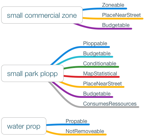
Three different types of tiles exist:
- Propable
- Ploppable
- Zoneable
Each tile type needs to function slightly different.
This type of tile describes map objects that function as more or less decorative objects.
Examples include: water, tree, rock, mountain
A "ploppable" is a predefined tile that can be added to the map. Most ploppables have statistical effects (for example: a park has a positive statistical value associated with the land value layer). A ploppable has a cost for buying it and ongoing cost to cover it's operation.
Examples include: park, hospital, street
Zoneables are tiles that are filled with buildings by the simulation.
The act of filling a zoneable is called "growing".
Examples include: residential zone, commercial zone, industrial zone
Tiles may adopt one or more of the following behaviours. These behaviours are implemented using protocols.
- not destructable: tile can not be removed from map
- must be placed near street: tile must be adjacent to street
- includes map statistics: tile contains statistic information
- can have conditions: condition example: on fire
- contains budget information: one time cost and/or running cost
- produces one ressource: see "Ressources"
- consumes one or more ressources: see "Ressources"
There will be two distinct ressources in the simulation that can be produced and consumed.
- electricity
- water
A ressource producer can produce only one ressource, for example:
A power plant produces electricity.
A ressource consumer can consume multiple ressources, for example:
A small fountain park consumes electricity and water.
A tile can adopt the RessourceCarrying protocol to signal the simulation that it is capable of transporting ressources.
A ressource carrier is always added to the map graph.
This is currently only planned for streets (StreetPlopp).
The following objects are emitting events by adopting the "EventEmitting" protocol.
Each event is given a payload.
Actors make use of the event system.
- Event "PopulationReachedThreshold", payload of type "Int"
- Event "AddTile", payload of type "Tileable"
- Event "RemoveTile", payload of type "Tileable"
The simulation is advanced in defined time intervals. Such an interval is called "tick".
By combining the numeric values of all statistical layers for a defined location (cell or tile), a "quality" score can be calculated and used throughout the simulation.
This allows, for example, to choose fitting locations for "growing" buildings in zoneables.
Actors are lightweight objects that advance the simluation state. They should, however, not contain any state themself.
Actors are added to the simulation as needed. For example, you may not want to add the FireActor, responsible for starting fires, right away but later on when the player can handle such events - thus allowing a smoother learning curve for the player.
Actors make use of the event system so they can react to certain situations.
It is planned to implement numerous actors, for example:
- BudgetActor: manages budget
- ElectricityActor: manages electricity
- WaterActor: manages water
- FireActor: manages fires
- CrimeActor: manages crimes
- ZoneDevelopmentActor: manages zone development
The "Budget" actor updates the currently available budget.
It subscribes to the "AddTile" and "RemoveTile" events of the CityMap.
When adding or removing a tile to/from the TileLayer that contain cost, (are "Budgetable") they will be handled by this actor.
It runs every 10 ticks and subtracts the current total ongoing cost from the budget and adds collected taxes to it.
The "Electricity" actor manages the current state of production and consumption of electricity, it also updates tiles on the TileLayer to reflect if they get electricity or not (condition: .NotPowered).
It subscribes to the "AddTile" and "RemoveTile" events of the CityMap.
When adding or removing a tile to/from the TileLayer that produce or consume ressources (are "RessourceProducing" or "RessourceConsuming"), they will be handled by this actor - it updates the internal state regrading electricity in the City object and also updates the Condition of relevant tiles.
I'm currently extending the data model for non-map related statistics. Also, the "Actor" api is beeing created and tested by implementing actors.
Carthage support is planned
var cityMap = CityMap(height: 1024, width: 1024)
var city = City(map: cityMap, startingBudget: 50000)
var simulation = Simulation(city: city)
bundle install
Docs are generated using jazzy. To update, run:
bundle exec "jazzy"


