From space to coast: a semi-automatic quantative review on remote sensing of coastal ecosystems
RS-eco
Abstract
Direct sampling of marine communities can be very difficult. Thus, marine research intensively relies on indirect observation methods, such as tethered video surveys or the use of Remotely Operated Vehicles (ROVs) and Autonomous Underwater Vehicles (AUVs). Bathymetry and environmental data are often gathered through ship-based sensors or airborne and satellite systems, which allow for continuous sampling over large spatial and temporal scales. In situ observations using unmanned aerial vehicles (UAVs), camera traps and acoustic sensors provide another indirect sampling method. All these methods have been increasingly used and have helped to acquire a vast amount of data, which helps us to further our scientific understanding and make predictions about future changes in marine ecosystems. Although, coastal communities are more accessible than most of the marine realm and can thus also be easily studied without remote sensing, the accessibility also means that they are more easily threatened by anthropogenic activities, such as coastal pollution and land use change. Thus, coastal ecosystems are an important research area, which are frequently studied using direct sampling but also remote sensing. Here, a quantitative literature review of the current literature on remote sensing and coastal ecosystems was performed. A total number of 3835 peer-reviewed journal publications was identified using Web of Knowledge and significant patterns and trends in these publications were identified. There was an exponential increase in the number of publications from 1990 - 2017, with a particular sharp increase since 2000. Most studies on remote sensing in coastal ecosystems have been conducted in China, India, Mali, Australia, Brazil, North America and Mexico. There was a strong difference in the number of publications by research topic, as well as by coastal ecosystem and taxonomic group. Most studies further utilised multispectral imagery, rather than hyperspectral, lidar or radar data and also mostly used Modis and Landsat imagery. …
Keywords: marine, satellite, biodiversity, conservation, climate change, pollution
Introduction
Global change is a hot topic in environmental and ecological research. It imposes challenges not only to the research, but also to the management and policy community and these challenges are likely to increase even further in the future (Pereira et al. 2010). Understanding current and making reliable predictions of future changes, enables us to prepare for these challenges, but also requires the collection of a vast amount of data.
Collecting field data is generally very resource intensive and difficult
to implement across large spatial and temporal scales. Remote Sensing
(RS) offers a good alternative and thus is an important tool for
measuring environmental conditions, as well as the state of biological
diversity and ecosystem services across multiple spatial and temporal
scales. Thus, it is not surprising that the use of RS has experienced an
exponential increase over the past decade (Pettorelli et al. 2014).
Sensors, methodologies and data availability have strongly developed and
using RS has become simpler and more widespread (Palmer et al. 2014).
This is not only true for the terrestrial environment, but RS has also
become increasingly important in studying coastal and marine ecosystems
(Brewington et al. 2014).
The direct sampling of coastal and marine communities is much harder
than the direct sampling of terrestrial communities. Thus, coastal and
marine research intensively relies on indirect observation methods, such
as tethered video surveys (Biber et al. 2014) or the use of Remotely
Operated Vehicle (ROVs; Lorance & Trenkel 2006) and Autonomous
Underwater Vehicle (AUVs; Eriksen et al. 2001, Yoerger et al. 2007).
Bathymetry and environmental data are often gathered through ship-based
sensors or airborne (Scheritz & Dietrich 2002, Koh & Wich 2012) and
satellite systems (Baldock et al. 2014), which allow for continuous
sampling over large spatial and temporal scales. In situ observations
using unmanned aerial vehicles (UAVs), camera traps (Bailey et
al. 2007, Ahumada et al. 2011) and acoustic sensors (Van Parijs et
al. 2009) provide another indirect sampling method.
These methods have already been applied in a large range of areas of coastal and marine research (Brewington et al. 2014). Environmental variables, such as sea surface temperature (Smit et al. 2013, Baldock et al. 2014), chlorophyll-α (Dierssen 2010, Raitsos et al. 2013), salinity (Lagerloef et al. 1995, 2008) and suspended particulate matter concentration (Evans et al. 2012, Bowers et al. 2014) can be easily obtained from satellite measurements and are frequently used in marine environmental research. Sea floor features and bathymetry have been widely mapped using ship-based depth soundings and satellite altimetry (Smith 1997, Becker et al. 2009). Remote sensing can also be used for shoreline change detection (Chen & Rau 1998, Li et al. 2001), mapping of coastal habitats, such as salt marshes (Ozesmi & Bauer 2002, Belluco et al. 2006), coral reefs (Lirman et al. 2007, Huvenne et al. 2011), as well as seagrass (Pasqualini et al. 2001) and mangrove ecosystems (Giri et al. 2011, Satyanarayana et al. 2011), fisheries management (Stuart et al. 2011), species movements (Lander et al. 2013) and risk assessment (Gillespie et al. 2007, Römer et al. 2012).
Although, coastal communities are more accessible than most of the marine realm and so can be studied much easier than for example the deep-sea, the better accessibility also means that they are more easily threatened by anthropogenic activities. A significant proportion of the global human population lives in close proximity to the coast and so causes the pollution and land degradation of coastal ecosystems. Thus, coastal ecosystems are an important research area, which are frequently studied using direct sampling but also remote sensing.
Rose et al. (2014) identified 10 topics, where using remotely sensed data would help to answer important conservation questions. These topics are: species distributions and abundances, species movements and life stages, ecosystem processes, climate effects, rapid response, protected areas, ecosystem services, conservation effectiveness, agricultural and aquacultural expansions and changes in land use land cover (LULC) and degradation and disturbance regimes. These topics highlight the importance of RS not only for conservation but also for environmental research in general, especially with regard to climate and land-use change.
In the following, trends and patterns in the current literature on remote sensing and coastal ecosystems will be analysed. I will further highlight, which of the 10 topics, identified by Rose et al. (2014), are already intensively studied in coastal ecosystems and where further research is required in the future in order to provide essential information for mitigating future effects of global change.
Materials and Methods
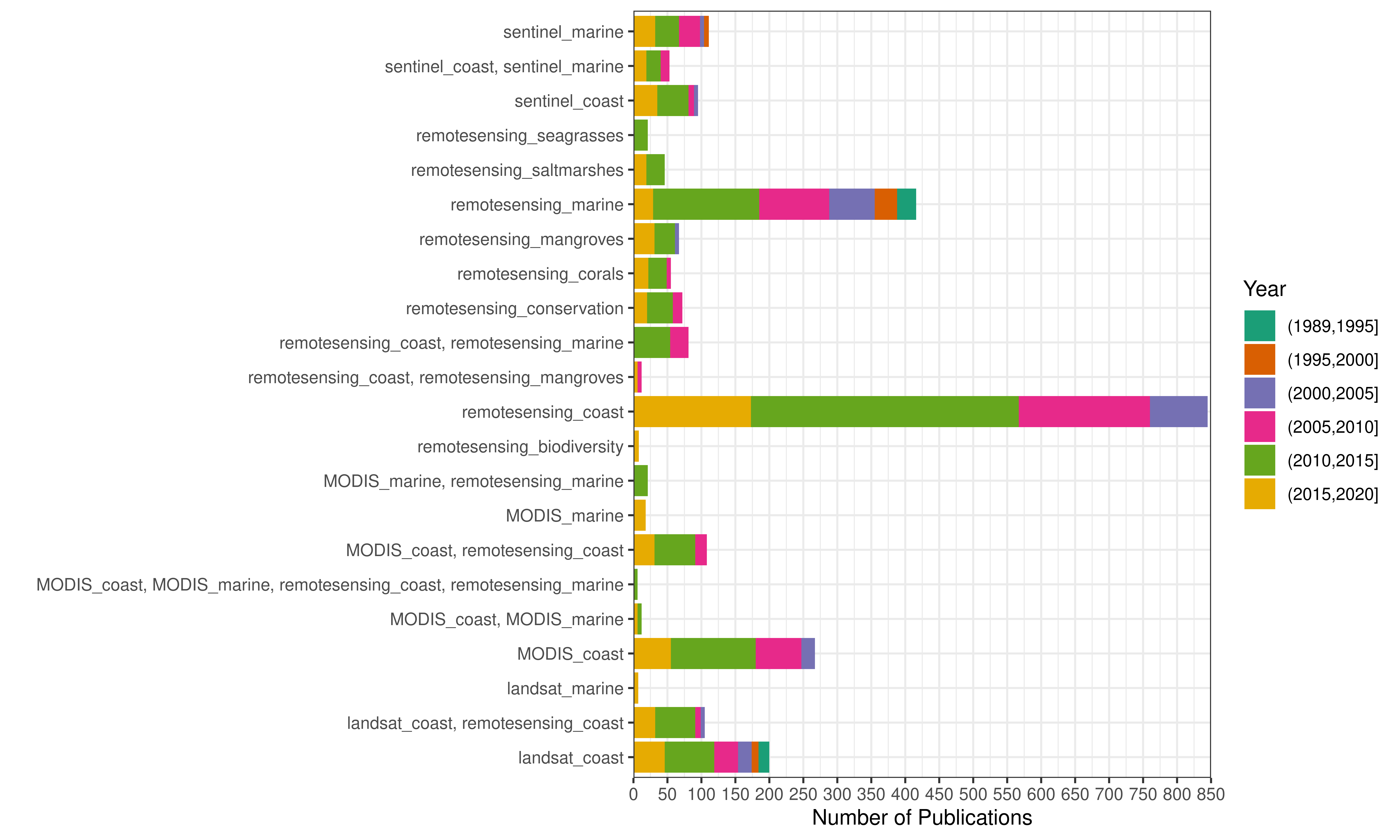
A literature search for peer-reviewed publications, published in English over the period 1990–2018, describing coastal studies using remote sensing was performed. The literature search was undertaken using the commercial search engine Web of Science. Combinations of the following search terms were used: ‘remote sensing’, ‘coast’, ‘marine’, ‘landsat’, ‘MODIS’, ‘Sentinel’, ‘seagrass’, ‘corals’, ‘mangroves’, ‘salt marsh’, ‘salt marshes’, ‘biodiversity’ and ‘conservation’. For a list of the exact search terms and the resulting number of publications see Table S1. The number of publications that overlapped among the different search terms is further depicted in Fig. S1. Only peer-reviewed articles were chosen as they form the main body of literature widely available to researchers. The articles used therefore did not include any university theses, technical governmental reports or conference proceedings.
Results
The search terms resulted in a total of 8803 studies of which 3754 publications (43%) were related to coastal studies and remote sensing. Of the 3754 publications that were analysed, 30 publications did not contain an abstract.
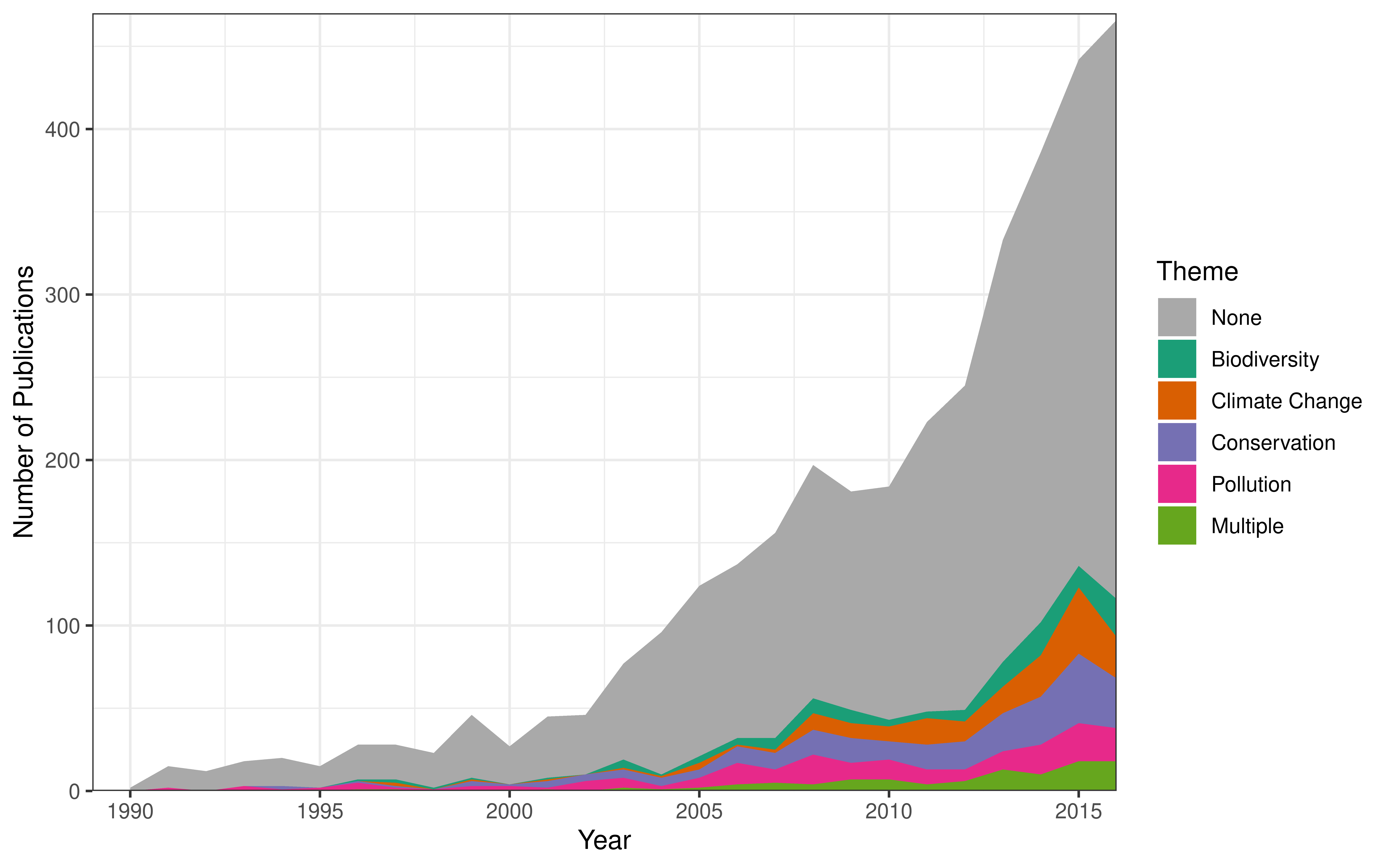
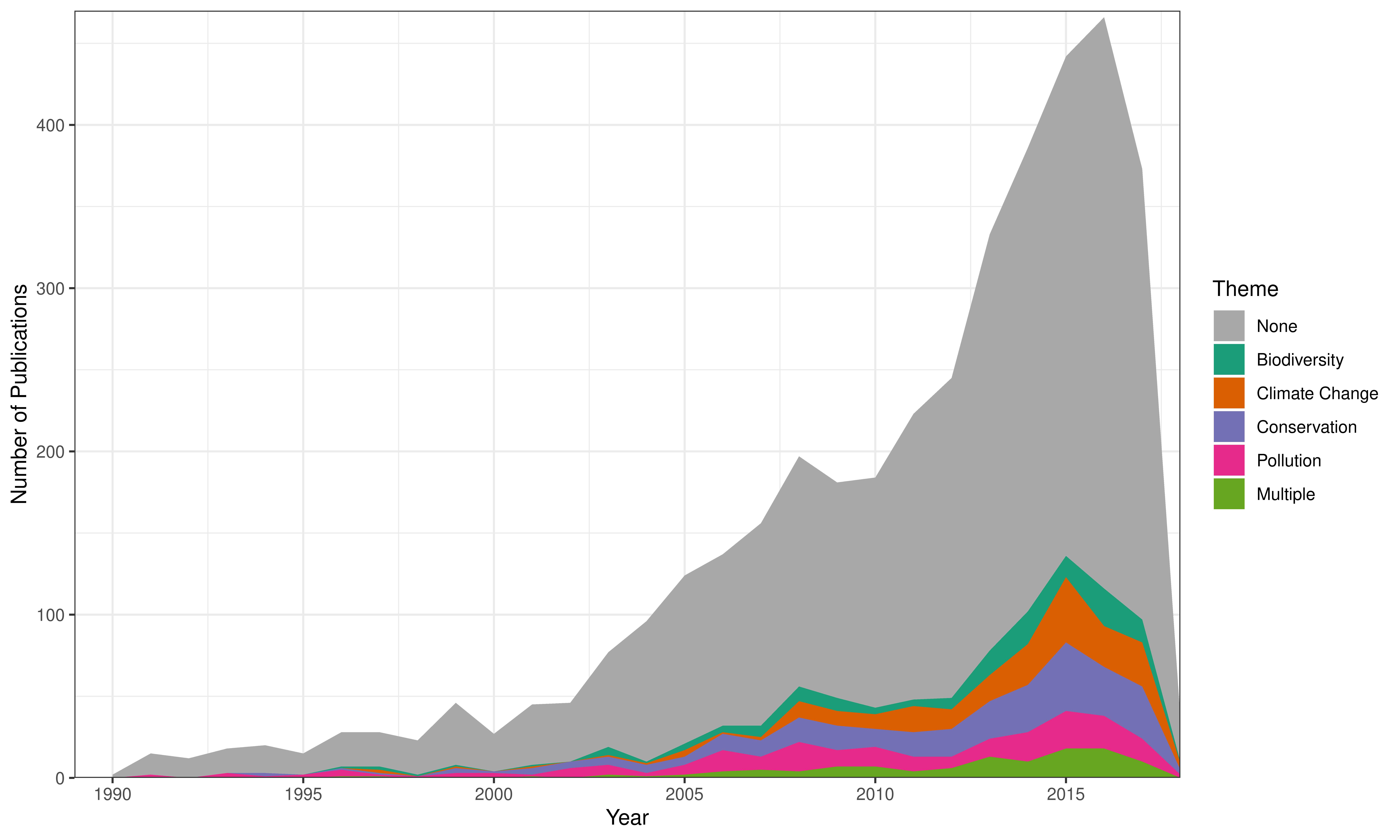
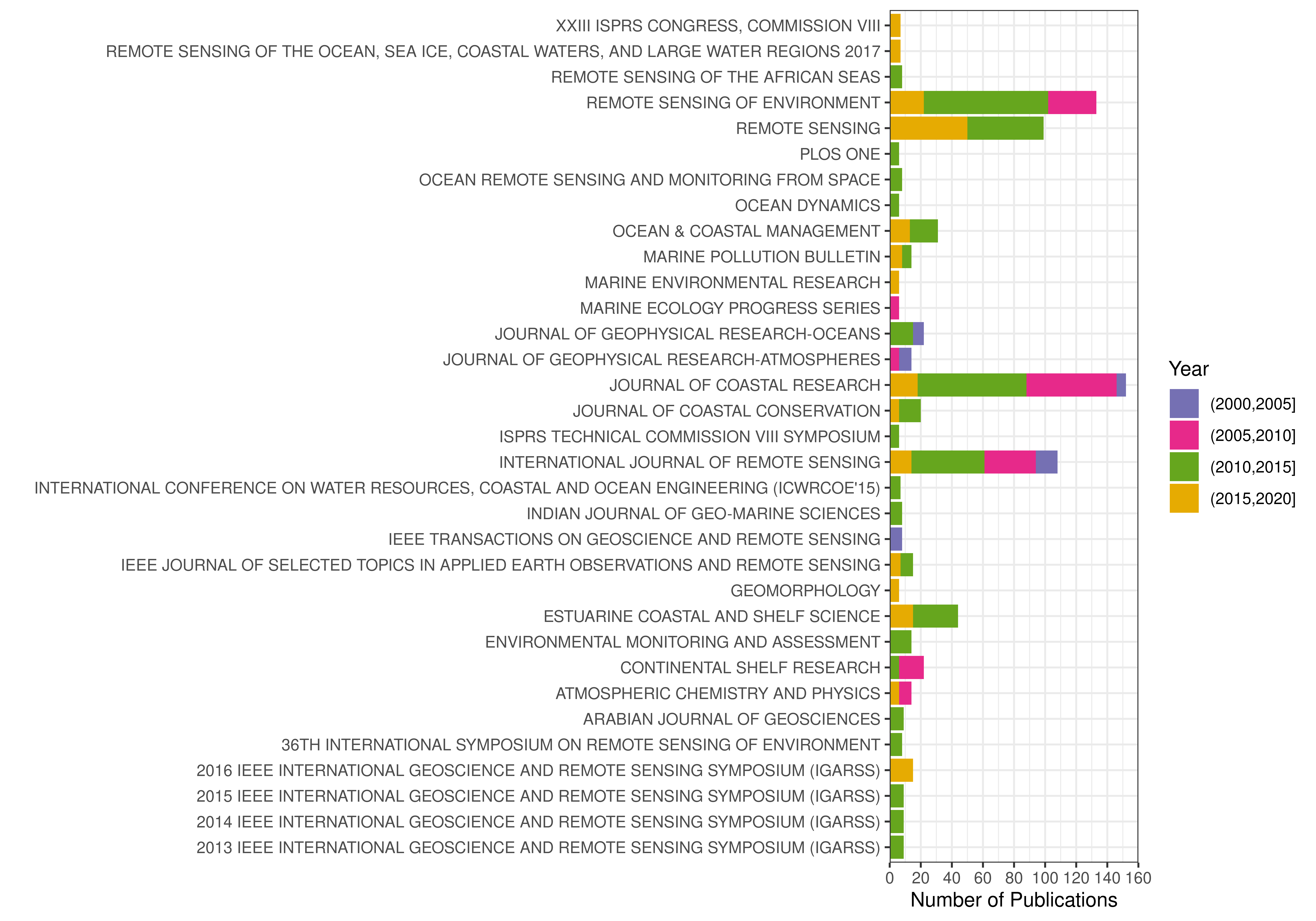
There was an exponential increase in the number of publications from 1990 - 2017, with a particular sharp increase since 2000. Only from 1999 to 2000 and from 2008 to 2010 there was a decrease in the number of publications. 94% of publications have been published since 2000, and 50% within the last 5 years (Fig. 1, Fig. S2). The majority of studies have been published in four journals (Remote Sensing of Environment, Remote Sensing, Journal of Coastal Research, International Journal of Remote Sensing, Fig. S3).
Fig. 1. Number of coastal publications over time, which are related to remote sensing, until 2016. Number of publications is subdivided by the different research themes (biodiversity, climate change, conservation and pollution). Publications where non of the 4 research themes could be identified are highlighted in grey. See Fig. S2 for number of publications until now.
Studies were conducted in 184 different countries. In the majority of countries (85) only a few studies (0-5) have been conducted, while most studies have been conducted in China, India, Mali (> 250 studies per country) and Australia, Brazil, Mexico, United States (100 - 250 studies per country) (Fig. 2).
Fig. 2. (a) Number of studies per country and (b) number of countries with a certain number of studies. 498 studies were conducted in multiple countries.
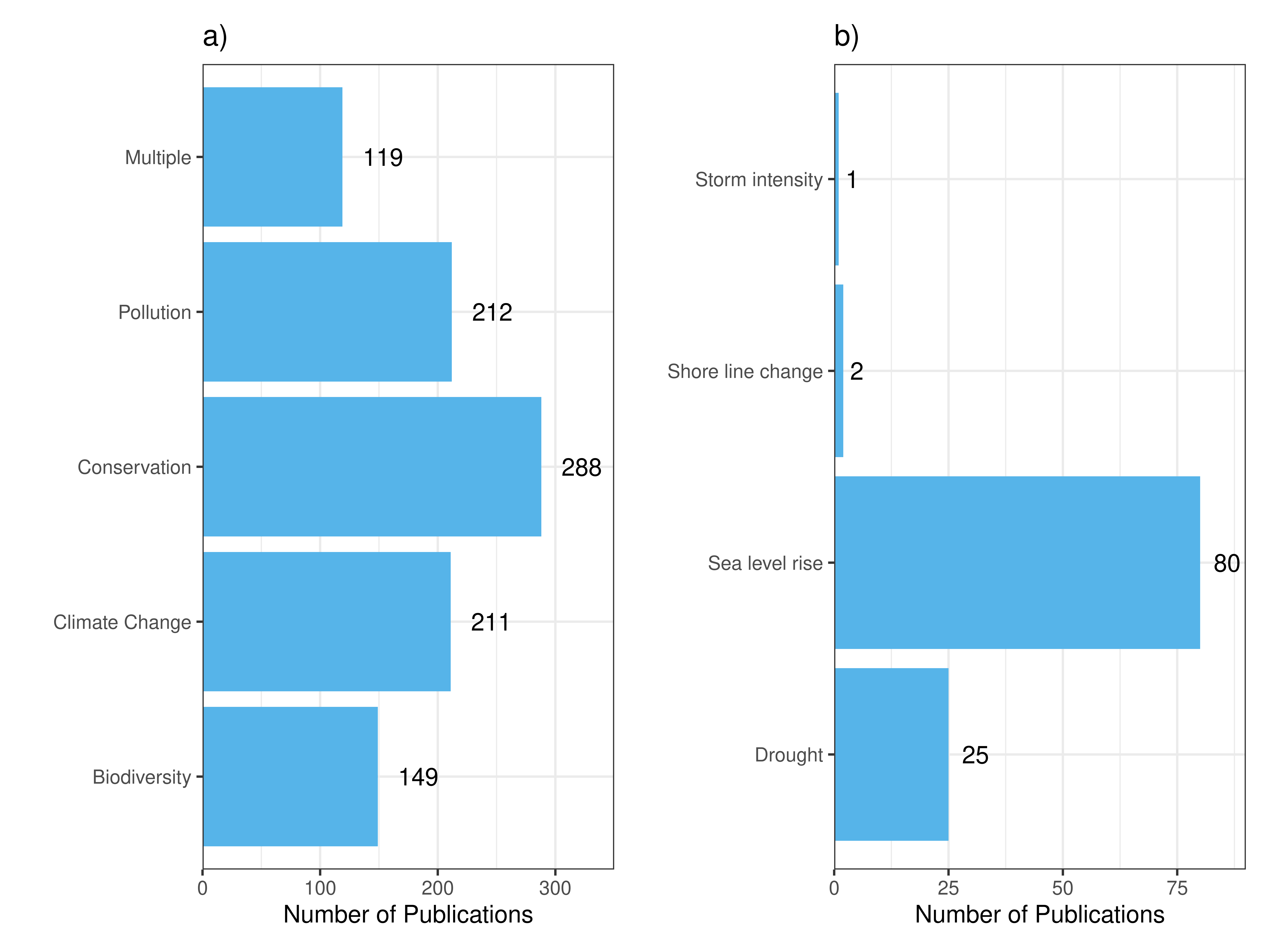
Coastal publications covered all major research themes. Most studies focused on conservation (288 publications), climate change and pollution were similarly frequently studied themes (211 and 212 publications), while biodiversity was the least studied theme in coastal remote sensing research (149, Fig. 1 & Fig. S3).
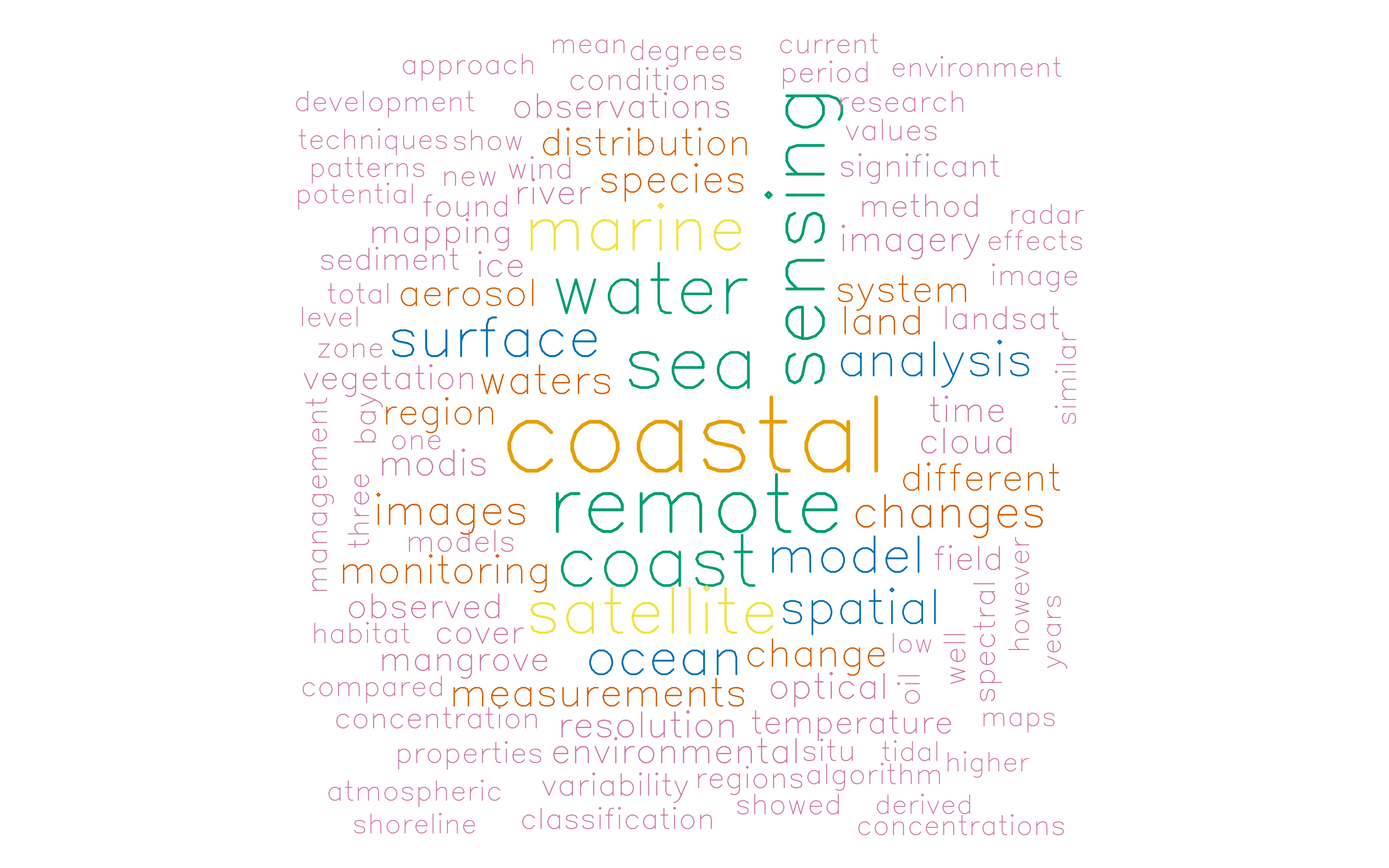
Fig. 3. Word cloud of the 100 most frequently used words in
abstracts and titles of the considered coastal literature.
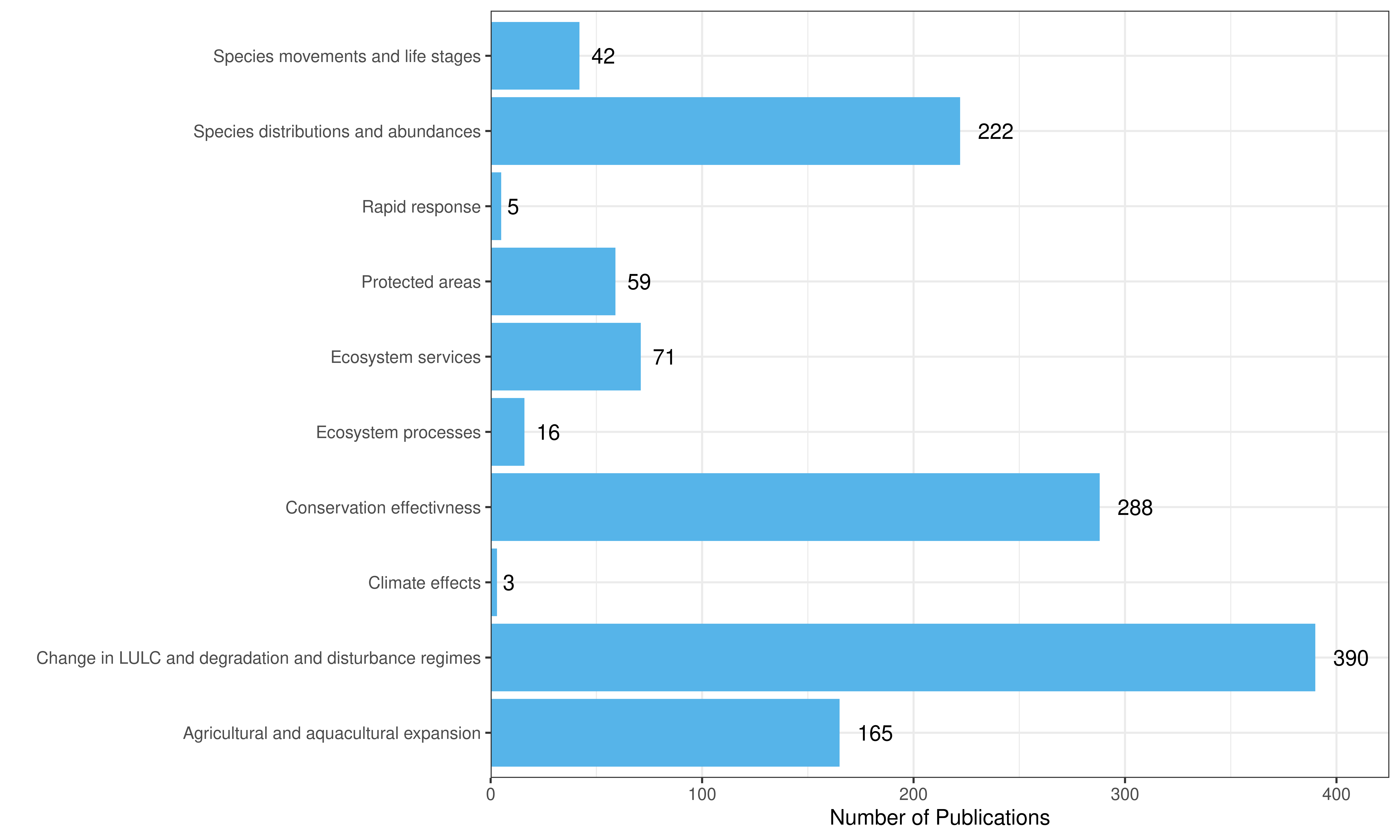
Most studies focused on land-use and land cover change and conservation
effectivness (390 and 288 publications). Species distributions and
abundances and agricultural and aquacultural expansion were also studied
by more than 100 studies. A fair number of studies also studied species
movements and life stages, protected areas and ecosystem services, while
only a marginal number of studies dealt with rapid response, ecosystem
processes and climate effects (Fig. 4).
Fig. 4. Number of publications by research topic.
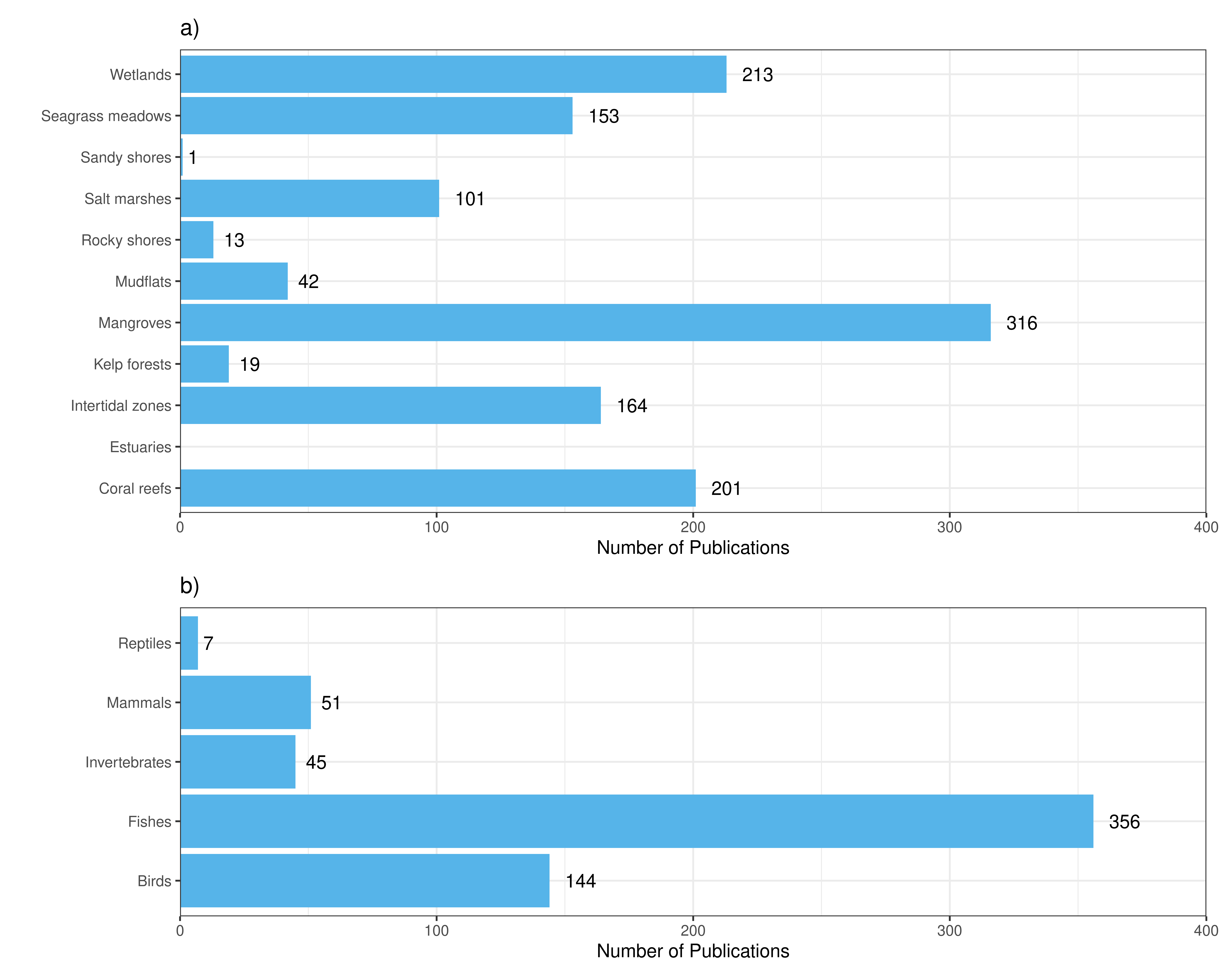
Mangrove forests were the coastal ecosystem that has been studied most using remote sensing (316 publications), followed by wetlands and coral reefs, which both have more than 200 publications. Salt marshes, intertidal zones and seagrass meadows have also been intensively studied (> 100 publications), while estuaries, kelp forests, mud flats, rocky shores and sandy shores have only been of minor interest (Fig. 5a).
Fishes are by far the most studied taxonomic group (371 publications), followed by birds (144 publications). Invertebrates and mammals were not so frequently studied, while marine reptiles have been hardly studied at all (Fig. 5b).
Fig. 5. Number of studies per coastal ecosystem (a) and taxonomic group (b).
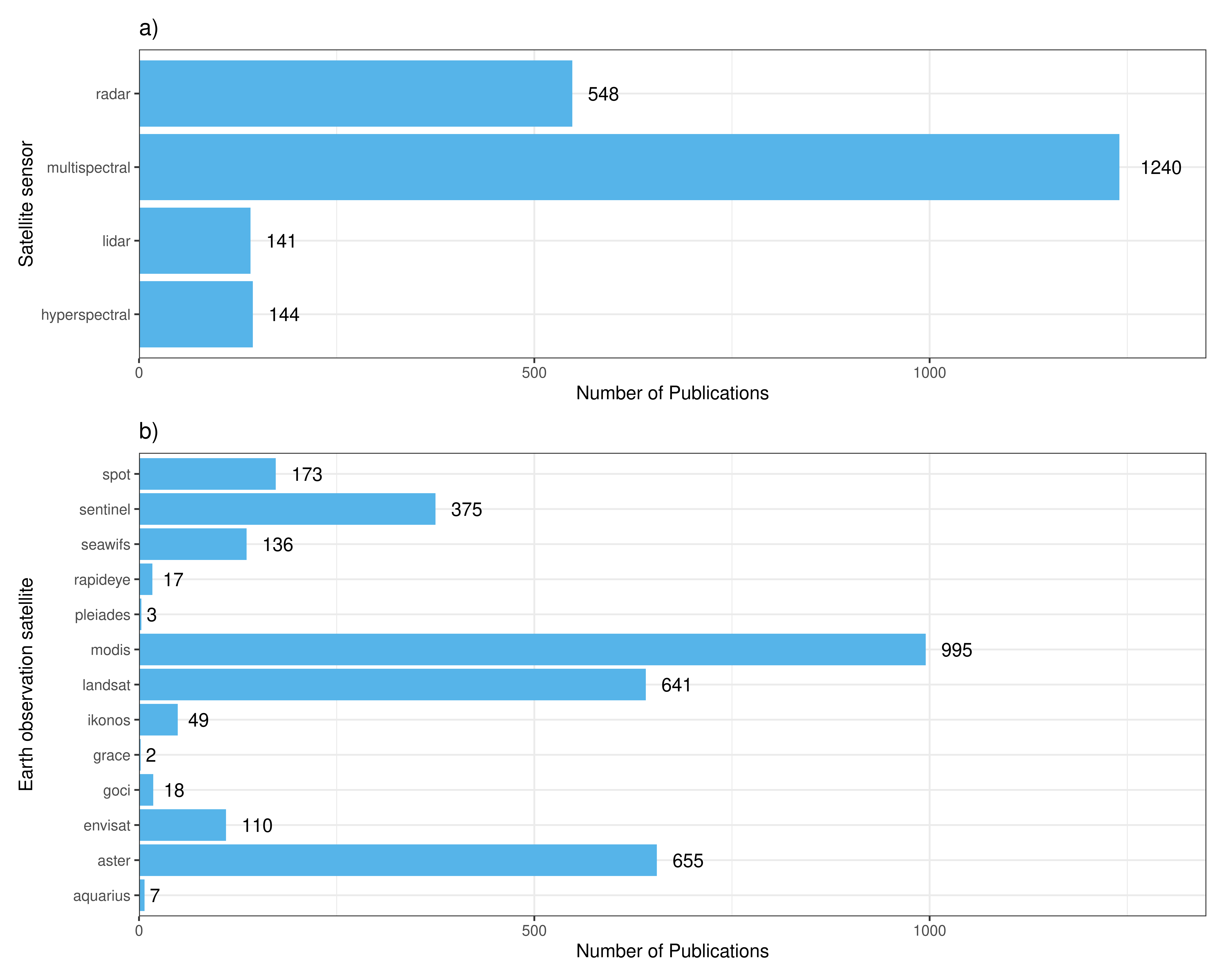
By far, the most number of studies (1240) were conducted using multispectral satellite imagery. Radar data was used in 548 publications, while hyperspectral and lidar data were used the least frequent (144 and 141 publications, Fig. 6a). MODIS, Landsat and Aster data has been used the most, but Envisat, Seawifs, Sentinel and Spot data have also been used frequently (Fig. 6b).
Fig. 6. Number of publications per spectrum (a) and Earth-observation satellite (b).
Discussion
Remote sensing has experienced an increasing use in recent decades (Pettorelli et al. 2014), which corresponds with the exponential increase in studies related to coastal remote sensing (Fig. 1). In recent years, RS has been more widely applied in the marine and coastal realm, but generally lies far behind the terrestrial application of RS. New upcoming satellite missions and open access to data products together with an increasing effort in teaching the analysis of remote sensing data to non-experts is most likely the cause for this. Nevertheless, technological difficulties are still hampering the use of RS, in particular in marine systems.
…
References
Ahumada JA, Silva CEF, Gajapersad K, Hallam C, Hurtado J, Martin E, McWilliam A, Mugerwa B, O’Brien T, Rovero F, Sheil D, Spironello WR, Winarni N, Andelman SJ (2011) Community structure and diversity of tropical forest mammals: data from a global camera trap network. Philos Trans R Soc Lond B Biol Sci 366:2703–2711
Alongi DM (2008) Mangrove forests: Resilience , protection from tsunamis , and responses to global climate change. 76:1–13
Andréfouët S, Berkelmans R, Odriozola L, Done T, Oliver J, Müller-Karger F (2002) Choosing the appropriate spatial resolution for monitoring coral bleaching events using remote sensing. Coral Reefs Volume 21:147–154
Bailey DM, King NJ, Priede IG (2007) Cameras and carcasses: historical and current methods for using artificial food falls to study deep-water animals. 350:179–191
Baldock J, Bancroft KP, Williams M, Shedrawi G, Field S (2014) Accurately estimating local water temperature from remotely sensed satellite sea surface temperature: A near real-time monitoring tool for marine protected areas. Ocean Coast Manag 96:73–81
Becker JJ, Sandwell DT, Smith WHF, Braud J, Binder B, Depner J, Fabre D, Factor J, Ingalls S, Kim S-H, Ladner R, Marks K, Nelson S, Pharaoh a., Trimmer R, Rosenberg J Von, Wallace G, Weatherall P (2009) Global Bathymetry and Elevation Data at 30 Arc Seconds Resolution: SRTM30_PLUS. Mar Geod 32:355–371
Belluco E, Camuffo M, Ferrari S, Modenese L, Silvestri S, Marani A, Marani M (2006) Mapping salt-marsh vegetation by multispectral and hyperspectral remote sensing. Remote Sens Environ 105:54–67
Bernal MA, Sinai NL, Rocha C, Gaither MR, Dunker F, Rocha LA (2015) Long-term sperm storage in the brownbanded bamboo shark Chiloscyllium punctatum. J Fish Biol 86:1171–1176
Biber MF, Duineveld GCA, Lavaleye MSS, Davies AJ, Bergman MJN, Beld IMJ van den (2014) Investigating the association of fish abundance and biomass with cold-water corals in the deep Northeast Atlantic Ocean using a generalised linear modelling approach. Deep Res Part II Top Stud Oceanogr 99:134–145
Bowers DG, Hill PS, Braithwaite KM (2014) The effect of particulate organic content on the remote sensing of marine suspended sediments. Remote Sens Environ 144:172–178
Brewington L, Frizzelle BG, Walsh SJ, Mena CF, Sampedro C (2014) Remote Sensing of the Marine Environment: Challenges and Opportunities in the Galapagos Islands of Ecuador. In: Denkinger J, Vinueza L (eds) The Galapagos Marine Reserve: A Dynamic Social-Ecological System.p 322
Chen LC, Rau JY (1998) Detection of shoreline changes for tideland areas using multi-temporal satellite images. Int J Remote Sens 19:3383–3397
Costanza R, D’Arge R, Groot R de, Farber S, Grasso M, Hannon B, Limburg K, Naeem S, O’Neill R, Paruelo J, Raskin R, Sutton P, Belt M van den (1997) The value of the world’s ecosystem services and natural capital. Nature 387
Cousins NJ, Linley TD, Jamieson AJ, Bagley PM, Blades H, Box T, Chambers R, Ford A, Shields MA, Priede IG (2013) Bathyal demersal fishes of Charlie-Gibbs Fracture Zone region (49-54°N) of the Mid-Atlantic Ridge: II. Baited camera lander observations. Deep Res Part II Top Stud Oceanogr 98:397–406
Deguignet M, Juffe-Bignoli D, MacSharry B, Burgess ND, Kingston N (2014) 2014 United Nations List of Protected Areas. UNEP-WCMC, Cambridge, UK
Dierssen HM (2010) Perspectives on empirical approaches for ocean color remote sensing of chlorophyllin a changing climate. Proc Natl Acad Sci 107:17073–17078
Edgar GJ, Stuart-Smith RD, Willis TJ, Kininmonth S, Baker SC, Banks S, Barrett NS, Becerro MA, Bernard ATF, Berkhout J, Buxton CD, Campbell SJ, Cooper AT, Davey M, Edgar SC, Försterra G, Galván DE, Irigoyen AJ, Kushner DJ, Moura R, Parnell PE, Shears NT, Soler G, Strain EM a, Thomson RJ (2014) Global conservation outcomes depend on marine protected areas with five key features. Nature 506:216–20
Eriksen CC, Osse TJ, Light RD, Wen T, Lehman TW, Sabin PL, Ballard JW, Chiodi AM (2001) Seaglider: A Long-Range Autonomous Underwater Vehicle for Oceanographic Research. 26:424–436
Evans RD, Murray KL, Field SN, Moore JAY, Shedrawi G, Huntley BG, Fearns P, Broomhall M, Mckinna LIW, Marrable D (2012) Digitise This! A Quick and Easy Remote Sensing Method to Monitor the Daily Extent of Dredge Plumes. 7
Fabry VJ, Seibel BA, Feely RA, Orr JC (2008) Impacts of ocean acidification on marine fauna and ecosystem processes. ICES J Mar Sci 65:414–432
Game ET, Grantham HS, Hobday AJ, Pressey RL, Lombard AT, Beckley LE, Gjerde K, Bustamante R, Possingham HP, Richardson AJ (2009) Pelagic protected areas: the missing dimension in ocean conservation. Trends Ecol Evol 24:360–369
Gillespie TW, Chu J, Frankenberg E, Thomas D (2007) Assessment and prediction of natural hazards from satellite imagery. Prog Phys Geogr 31:459–470
Giri C, Ochieng E, Tieszen LL, Zhu Z, Singh A, Loveland T, Masek J, Duke N (2011) Status and distribution of mangrove forests of the world using earth. … :154–159
Groom G, Stjernholm M, Nielsen RD, Fleetwood A, Petersen IK (2013) Remote sensing image data and automated analysis to describe marine bird distributions and abundances. Ecol Inform 14:2–8
Guinotte JM, Davies AJ (2014) Predicted Deep-Sea Coral Habitat Suitability for the U.S. West Coast. 9
Haas C, Lobach J, Hendricks S, Rabenstein L, Pfaffling A (2009) Helicopter-borne measurements of sea ice thickness, using a small and lightweight, digital EM system. J Appl Geophys 67:234–241
Hoegh-Guldberg O, Mumby PJ, Hooten a J, Steneck RS, Greenfield P, Gomez E, Harvell CD, Sale PF, Edwards a J, Caldeira K, Knowlton N, Eakin CM, Iglesias-Prieto R, Muthiga N, Bradbury RH, Dubi a, Hatziolos ME (2007) Coral reefs under rapid climate change and ocean acidification. Science 318:1737–1742
Huvenne VAI, Tyler PA, Masson DG, Fisher EH, Hauton C, Hühnerbach V, Bas TP, Wolff G a (2011) A picture on the wall: Innovative mapping reveals cold-water coral refuge in submarine canyon. PLoS One 6:e28755
Jackson E, Davies A, Howell K, Kershaw P, Hall-Spencer J (2014) Future-proofing marine protected area networks for cold water coral reefs. ICES J Mar Sci
Jacoby DMP, Brooks EJ, Croft DP, Sims DW (2012) Developing a deeper understanding of animal movements and spatial dynamics through novel application of network analyses. :574–583
Jeffreys RM, Lavaleye MSS, Bergman MJN, Duineveld GCA, Witbaard R, Linley T (2010) Deep-sea macrourid fishes scavenge on plant material: Evidence from in situ observations. Deep Sea Res Part I Oceanogr Res Pap 57:621–627
Juntunen T, Vanhatalo J, Peltonen H, Mäntyniemi S (2012) Bayesian spatial multispecies modelling to assess pelagic fish stocks from acoustic- and trawl-survey data. ICES J Mar Sci 69:95–104
Knudby A, Pittman SJ, Maina J, Rowlands G (2014) Remote Sensing and Modeling of Coral Reef Resilience. In: Remote Sensing and Modeling: Advances in Coastal and Marine Resources.p 494
Koh LP, Wich SA (2012) Dawn of drone ecology: low-cost autonomous aerial vehicles for conservation. 5:121–132
Kraan C, Meer J Van Der, Dekinga A, Piersma T (2009) Patchiness of macrobenthic invertebrates in homogenized intertidal habitats: hidden spatial structure at a landscape scale. 383:211–224
la Torre-Castro M de, Rönnbäck P (2004) Links between humans and seagrasses—an example from tropical East Africa. Ocean Coast Manag 47:361–387
Lagerloef G, Colomb FR, Vine D Le, Wentz F, Yueh S, Ruf C, Lilly J, Gunn J, Chao Y, DeCharon A, Feldman G, Swift C (2008) The Aquarius/SAC-D Mission: Designed to Meet the Salinity Remote-Sensing Challenge. Oceanography 21:68–81
Lagerloef GSE, Swift CT, LeVine DM (1995) Sea Surface Salinity: The Next Remote Sensing Challenge. Oceanography 8:44–50
Lander ME, Fritz LW, Johnson DS, Logsdon MG (2013) Population trends of Steller sea lions (Eumetopias jubatus) with respect to remote sensing measures of chlorophyll-a in critical habitat. Mar Biol 160:195–209
Laxon SW, Giles K a., Ridout AL, Wingham DJ, Willatt R, Cullen R, Kwok R, Schweiger A, Zhang J, Haas C, Hendricks S, Krishfield R, Kurtz N, Farrell S, Davidson M (2013) CryoSat-2 estimates of Arctic sea ice thickness and volume. Geophys Res Lett 40:732–737
Leifer I, Lehr WJ, Simecek-Beatty D, Bradley E, Clark R, Dennison P, Hu Y, Matheson S, Jones CE, Holt B, Reif M, Roberts DA, Svejkovsky J, Swayze G, Wozencraft J (2012) State of the art satellite and airborne marine oil spill remote sensing: Application to the BP Deepwater Horizon oil spill. Remote Sens Environ 124:185–209
Li R, Liu J-K, Felus Y (2001) Spatial Modeling and Analysis for Shoreline Change Detection and Coastal Erosion Monitoring. Mar Geod 24:1–12
Lirman D, Gracias NR, Gintert BE, Gleason ACR, Reid RP, Negahdaripour S, Kramer P (2007) Development and application of a video-mosaic survey technology to document the status of coral reef communities. Environ Monit Assess 125:59–73
Lorance P, Trenkel V (2006) Variability in natural behaviour, and observed reactions to an ROV, by mid-slope fish species. J Exp Mar Bio Ecol 332:106–119
Marouchos A, Sherlock M, Barker B, Williams A (2011) Development of a
stereo deepwater Baited Remote Underwater Video System (DeepBRUVS).
Ocean 2011 IEEE - Spain:1–5
Marshall CE, Glegg GA, Howell KL (2014) Species distribution modelling
to support marine conservation planning: The next steps. Mar Policy
45:330–332
Martinez I, Jones EG, Davie SL, Neat FC, Wigham BD, Priede IG (2011) Variability in behaviour of four fish species attracted to baited underwater cameras in the North Sea. Hydrobiologia 670:23–34
McGlathery KJ, Sundbäck K, Anderson IC (2007) Eutrophication in shallow coastal bays and lagoons: The role of plants in the coastal filter. Mar Ecol Prog Ser 348:1–18
Meager J, Schlacher T, Green M (2011) Topographic complexity and landscape temperature patterns create a dynamic habitat structure on a rocky intertidal shore. Mar Ecol Prog Ser 428:1–12
Nagendra H, Lucas R, Honrado JP, Jongman RHG, Tarantino C, Adamo M, Mairota P (2013) Remote sensing for conservation monitoring: Assessing protected areas, habitat extent, habitat condition, species diversity, and threats. Ecol Indic 33:45–59
Ozesmi SL, Bauer ME (2002) Satellite remote sensing of wetlands. Wetl Ecol Manag 10:381–402
Palmer SCJ, Kutser T, Hunter PD (2014) Remote sensing of inland waters: Challenges , progress and future directions. Remote Sens Environ
Parijs SM Van, Clark CW, Sousa-Lima RS, Parks SE, Rankin S, Risch D, Opzeeland IC Van (2009) Management and research applications of real-time and archival passive acoustic sensors over varying temporal and spatial scales. Mar Ecol Prog Ser 395:21–36
Pasqualini V, Pergent-Martini C, Clabaut P, Marteel H, Pergent G (2001) Integration of Aerial Remote Sensing, Photogrammetry, and GIS Technologies in Seagrass Mapping. Photogramm Eng Remote Sensing 67:99–105
Pendoley KL, Schofield G, Whittock PA, Ierodiaconou D, Hays GC (2014) Protected species use of a coastal marine migratory corridor connecting marine protected areas. :1455–1466
Pereira HM, Leadley PW, Proença V, Alkemade R, Scharlemann JPW, Fernandez-Manjarrés JF, Araújo MB, Balvanera P, Biggs R, Cheung WWL, Chini L, Cooper HD, Gilman EL, Guénette S, Hurtt GC, Huntington HP, Mace GM, Oberdorff T, Revenga C, Rodrigues P, Scholes RJ, Sumaila UR, Walpole M (2010) Scenarios for global biodiversity in the 21st century. Sciencexpress 330:1496–1501
Pettorelli N, Laurance WF, Brien TGO, Wegmann M, Nagendra H, Turner W (2014) Satellite remote sensing for applied ecologists: opportunities and challenges. … :839–848
Polunin SKWNAJGNVC (2007) Appraisal of visual assessments of habitat complexity and benthic composition on coral reefs. … :1069–1076
Rahman AF, Dragoni D, Didan K, Barreto-Munoz A, Hutabarat J a. (2013) Detecting large scale conversion of mangroves to aquaculture with change point and mixed-pixel analyses of high-fidelity MODIS data. Remote Sens Environ 130:96–107
Raitsos DE, Pradhan Y, Brewin RJW, Stenchikov G, Hoteit I (2013) Remote Sensing the Phytoplankton Seasonal Succession of the Red Sea. 8
R Core Team (2020). R: A language and environment for statistical computing. R Foundation for Statistical Computing, Vienna, Austria. URL https://www.R-project.org/.
Römer H, Willroth P, Kaiser G, Vafeidis a. T, Ludwig R, Sterr H, Revilla
Diez J (2012) Potential of remote sensing techniques for tsunami hazard
and vulnerability analysis-a case study from Phang-Nga province,
Thailand. Nat Hazards Earth Syst Sci 12:2103–2126
Satyanarayana B, Mohamad KA, Idris IF, Husain M-L, Dahdouh-Guebas F
(2011) Assessment of mangrove vegetation based on remote sensing and
ground-truth measurements at Tumpat, Kelantan Delta, East Coast of
Peninsular Malaysia. Int J Remote Sens 32:1635–1650
Scheritz M, Dietrich R (2002) Digital Elevation Model of Polygonal Patterned Ground on Samoylov Island , Siberia , Using Small-Format Aerial Photography. :1589–1594
Serreze MC, Holland M, Stroeve JC (2007) Perspectives on the Arctic’s shrinking sea-ice cover. Science (80- ) 315:1533–1536
Smit AJ, Roberts M, Anderson RJ, Dufois F, Dudley SFJ (2013) A Coastal Seawater Temperature Dataset for Biogeographical Studies: Large Biases between In Situ and Remotely-Sensed Data Sets around the Coast of South Africa. 8
Smith WH (1997) Global Sea Floor Topography from Satellite Altimetry and Ship Depth Soundings. Science (80- ) 277:1956–1962
Stroeve JC, Serreze MC, Holland MM, Kay JE, Malanik J, Barrett AP (2012) The Arctic’s rapidly shrinking sea ice cover: A research synthesis. Clim Change 110:1005–1027
Stuart V, Platt T, Sathyendranath S (2011) The future of fisheries science in management: a remote-sensing perspective.
Trenkel V, Lorance P, Mahevas S (2004) Do visual transects provide true population density estimates for deepwater fish? ICES J Mar Sci 61:1050–1056
Umitsu M, Tanavud C, Patanakanog B (2007) Effects of landforms on tsunami flow in the plains of Banda Aceh, Indonesia, and Nam Khem, Thailand. Mar Geol 242:141–153
Valiela I, Bowen JL, York JK (2001) Mangrove Forests: One of the World’s Threatened Major Tropical Environments. Bioscience 51:807
Vo QT, Oppelt N, Leinenkugel P, Kuenzer C (2013) Remote sensing in mapping mangrove ecosystems - an object-based approach. Remote Sens 5:183–201
Ward TJ, Vanderklift MA, Nicholls AO, Kenchington RA (1999) Selecting Marine Reserves Using Habitats and Species Assemblages As Surrogates For Biological Diversity. Ecol Appl 9:691–698
Watson R a., Coles RG, Long WJL (1993) Simulation estimates of annual yield and landed value for commercial penaeid prawns from a tropical seagrass habitat, northern Queensland, Australia. Aust J Mar Freshw Res 44:211–219
Waycott M, Duarte CM, Carruthers TJB, Orth RJ, Dennison WC, Olyarnik S, Calladine A, Fourqurean JW, Heck KL, Hughes a R, Kendrick G a, Kenworthy WJ, Short FT, Williams SL (2009) Accelerating loss of seagrasses across the globe threatens coastal ecosystems. Proc Natl Acad Sci U S A 106:12377–81
Wilson LJ, Mcsorley CA, Gray CM, Dean BJ, Dunn TE, Webb A, Reid JB (2009) Radio-telemetry as a tool to define protected areas for seabirds in the marine environment. Biol Conserv 142:1808–1817
Yoerger D, Bradley A, Jakuba M, German C, Shank T, Tivey M (2007) Autonomous and Remotely Operated Vehicle Technology for Hydrothermal Vent Discovery, Exploration, and Sampling. Oceanography 20:152–161
Supplementary Material
Supplementary Tables
Table S1. Search terms used and the resulting number of publications from the Web of Science Core Collection.
| Search term | Number of publications |
|---|---|
| remote sensing* coast | 1960 |
| remote sensing* marine | 2268 |
| landsat* coast | 516 |
| landsat* marine | 248 |
| MODIS* coast | 535 |
| MODIS* marine | 570 |
| Sentinel* coast | 282 |
| Sentinel* marine | 547 |
| remote sensing* seagrass | 228 |
| remote sensing* corals | 552 |
| remote sensing* mangroves | 472 |
| remote sensing* salt marsh | 203 |
| remote sensing* salt marshes | 203 |
| remote sensing* biodiversity | 1812 |
| remote sensing* conservation | 2658 |
Table S2. Category, value and the keywords used to identifiy the value of each category for each publication. All keywords word searched for in the title and abstract of each publication.
| Category | Value | Keywords |
|---|---|---|
| relevance | terrestrial | land, terrestrial |
| relevance | coastal | coast, estuar, intertidal, shore |
| relevance | marine | marine, deep-sea |
| country | countries | countries |
| theme | biodiversity | biodiversity |
| theme | conservation | conservation |
| theme | climate change | climate change |
| theme | pollution | pollution |
| topic | Species distributions and abundances | distribution & species, abundance & species |
| topic | Species movements and life stages | movement species, life & stage |
| topic | Ecosystem processes | ecosystem process |
| topic | Climate effects | climate effect |
| topic | Rapid response | rapid response |
| topic | Protected areas | protected area |
| topic | Ecosystem services | ecosystem service |
| topic | Conservation effectivness | conservation |
| topic | Agricultural and aquacultural expansion | agriculture, aquaculture |
| topic | Change in LULC and degradation and disturbance regimes | land use, degradation, disturbance |
| ecosystem | Seagrass meadows | sea grass, seagrass |
| ecosystem | Coral reefs | coral |
| ecosystem | Mangroves | mangrove |
| ecosystem | Salt marshes | salt marsh, saltmarsh |
| ecosystem | Rocky shores | rocky shore |
| ecosystem | Sandy shores | sandy shore |
| ecosystem | Mudflats | mud flat, mudflat |
| ecosystem | Estuary | estuary, estuaries, river |
| ecosystem | Intertidal zones | intertidal |
| ecosystem | Kelp forests | kelp |
| taxonomic group | Fishes | fish |
| taxonomic group | Mammals | mammal |
| taxonomic group | Birds | bird |
| taxonomic group | Invertebrates | invertebrate |
| taxonomic group | Reptiles | reptile |
| sensor | multispectral | multispectral, modis, landsat |
| sensor | hyperspectral | hyperspectral |
| sensor | radar | radar, sar |
| sensor | lidar | lidar |
| EO satellite | sentinel | sentinel |
| EO satellite | landsat | landsat-8 |
| EO satellite | MODIS | modis, aqua, terra |
| EO satellite | RapidEye | rapid & eye |
| EO satellite | Envisat | envisat, meris |
| EO satellite | Pleiades | pleiades |
| EO satellite | Spot | spot |
| EO satellite | SeaWifs | seawifs |
| EO satellite | Aquarius | aquarius |
| EO satellite | Grace | grace |
| EO satellite | GOCI | goci |
| EO satellite | Ikonos | ikonos |
| EO satellite | Aster | aster |
| EO satellite | Hyperion | hyperion |
| EO satellite | Aviris | aviris |
Supplementary Figures
Fig. S1. Number of publications that were identified by one or multiple search terms. Only search term combinations that yielded more than 5 publications are shown.
Fig. S2. Number of coastal publications over time, which are related to remote sensing, covering the entire time period (1990 - 2018).
Fig. S3. a) Number of publications by research theme (Pollution, Conservation, Climate Change, Biodiversity) and where multiple themes are covered. 3035 publications did not cover any of the research themes considered. b) Number of publications by climate change thematic.
Fig. S4. Number of coastal publications, which are related to remote sensing, per journal and year. Only journals were more than 5 publications were found are shown.
