Please feel free to help us to improve this page.
Awesome resource list for ArcGIS Developers
Table of contents
- Quick overview
- Getting started
- About ArcGIS
- Contributions
- ArcGIS community
- Localized resources lists
No matter your background or your favourite technology, we have putted together many links to help you find tools, code samples, training, and help you get started with ArcGIS.
Start check the section that best matches with you:
- Front-end developer
- Back-end developer
- Mobile developer
- Desktop developer
- DevOps
- Virtual reality developers
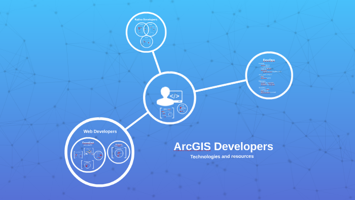
In order help you better understand the technology we have also collected some links to introduce you to the content you have available in the platform and which are the benefits of developing using ArcGIS.
This diagram displays an overview of the technologies available for ArcGIS developers:
You can sign up for free in order to be able to:
- Download some tools: the SDKs for mobile or desktop developers, Web AppBuilder Developer Edition, etc.
- Store data in ArcGIS Online
- Use de ArcGIS Online Web Map Editor
- Build Web Maps
- Use the ready to use services
- etc.
Know more about the developer plans.
ArcGIS is a 360º software platform built by Esri and it already have more than 100 software tools. Many of those tools are end-user software like desktop applications or mobile Applications but there are also many tools for developers and devops as you will see in this awesome list of resources.
About Esri
Esri (Environmental Systems Research Institute) was founded in 1969 by Jack and Laura Dangermond. Today it software ( ArcGIS ) is been used by a 40% of the global market. The company have more than 350000 customers worldwide, 8000 employees, 1600 partners, 90 offices and $1.1B on revenue.
It organize multiple events annually and the biggest one (the User Conference in San Diego) brings together more than 15000 users. There is also a developer focused event, the Developer Summit, it take place at Palm Springs (USA) and Berlin (EU) every year.
Check this diagram to know more about the GIS and Esri evolution:
If you want to know more about ArcGIS capabilities, features, ... we encourage you to can start checking some of these sites:
- ArcGIS capabilities: spatial analysis, real time, big data, 3D, imagery and sensors, etc.
- ArcGIS features: content ready to use, visualization, spatial analysis, team administrations, apps, tools for developers, etc.
- ArcGIS patterns: analysis and planification, operational awareness, field data collection, assets management and community engagement.
- How GIS works: five steps: ask, collect, examine, analyze and act.
Please feel free to contribute to this list. The technology change fast and some resources may be out to date.
A sample resources list that shows what we are trying to collect on each page is the Web AppBuilder resource page.
Ways to contribute:
- If you find a broken link feel free to open an issue or add a comment on Disqus
- If you find some missing information do the same thing
- You can help us just adding resources directly editing from your browser (learn how).
- If you are a developer you can also fork this repo and do a pull request.
Most of ArcGIS traditional users are in geonet.esri.com. There you will find several places where you will find more people and help grouped by technologies, countries, etc.
But you can also find developers with knowledge on ArcGIS at:
Some interesting twitter accounts you may want to follow:
@EsriDevSummit,
@EsriGeoDev,
@EsriTraining,
@EsriStartups,
@EsriMooc,
@EsriUKGeoDev,
@ArcPy, @EsriPDX
and some others Esri Accounts.
There are some extra resources in different languages, here you will find: