The goal of ripc is to provide access to Integrated Food Security Phase Classification (IPC) and Cadre Harmonisé (CH) data.
You can install the ripc from CRAN:
install.packages("ripc")The development version can be installed from GitHub:
# install.packages("remotes")
remotes::install_github("OCHA-DAP/ripc")ripc provides functionality to access IPC data stored directly on the
IPC-CH Public API. There are a wider set
of functions detailed further below, but most users will get the
information they need from the ipc_get_population() function which
returns datasets of country-level, group-level, and area-level analyses
in a list.
library(ripc)

df_list <- ipc_get_population()
df_list$country
#> # A tibble: 761 × 29
#>    analysis_id title       country condition analysis_date view_level ipc_period
#>          <dbl> <chr>       <chr>   <chr>     <chr>         <chr>      <chr>
#>  1    65508276 Acute Food… HT      A         Mar 2024      area       A
#>  2    65115079 Acute Food… PS      A         Feb 2024      area       C
#>  3    65115079 Acute Food… PS      A         Feb 2024      area       C
#>  4    65113995 Acute Food… KE      A         Feb 2024      area       A
#>  5    65113995 Acute Food… KE      A         Feb 2024      area       A
#>  6    65024769 Acute Food… SO      A         Jan 2024      area       A
#>  7    65024769 Acute Food… SO      A         Jan 2024      area       A
#>  8    64948217 Acute Food… MG      A         Dec 2023      area       A
#>  9    64948217 Acute Food… MG      A         Dec 2023      area       A
#> 10    64948217 Acute Food… MG      A         Dec 2023      area       A
#> # ℹ 751 more rows
#> # ℹ 22 more variables: population <dbl>, population_percentage <chr>,
#> #   period <chr>, from <chr>, to <chr>, analysis_period_start <date>,
#> #   analysis_period_end <date>, p3plus <dbl>, p3plus_percentage <dbl>,
#> #   estimated_population <dbl>, phase1_population <dbl>,
#> #   phase1_percentage <dbl>, phase2_population <dbl>, phase2_percentage <dbl>,
#> #   phase3_population <dbl>, phase3_percentage <dbl>, …
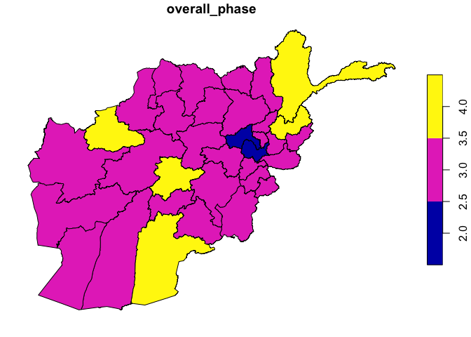
While the default is to return data frames to the user, you can directly access GeoJSON files from the IPC API.
df_areas <- ipc_get_areas(id = 12856213, period = "P", return_format = "geojson")
plot(df_areas[,"overall_phase"])
More details on the API are available below.
The ripc functions provide access to API endpoints detailed in the IPC-CH Public API documentation. The documentation should be referred to in order to better understand the API calls themselves (under the simplified and advanced documentation sections), and the returned data. For ease of the user, a table to match up the simplified and advanced API endpoints with ripc functions is below.
In general, the same functions can access both API endpoints, but the simplified endpoints are accessed with optional parameters while the advanced endpoints are accessed when IDs and/or periods are explicitly passed.
| ripc | IPC API |
|---|---|
ipc_get_analyses() |
analyses |
ipc_get_country() |
country |
ipc_get_areas() |
areas |
ipc_get_points() |
points |
ipc_get_icons() |
icons |
| ripc | IPC API |
|---|---|
ipc_get_analyses(id = ###) |
analysis/{id} |
ipc_get_areas(id = ###, period = X) |
areas/{id}/{period} |
ipc_get_population() |
population |
ipc_get_population(id = ###) |
population/{id} |
ipc_get_points(id = ###, period = X) |
points/{id}/{period} |
ipc_get_icons(id = ###, period = X) |
icons/{id}/{period} |
Please refer to the IPC API
documentation to learn how to generate a
token for the API you can use to access the data. This API key should be
stored in your environment as IPC_API_KEY. You can easily add this to
your environment by adding the following line to your .Renviron file,
easily accessed using usethis::edit_r_environ().
IPC_API_KEY="API key here"
Make sure that your API key is granted access to the resources you need.
Data coming from the IPC API isn’t immediately joinable, with varying
naming conventions for geographical name/ID columns. Outputs from the
ripc functions are wrangled to ease the joining of datasets together by
standardizing some column names and keeping the data in a tidy format.
You can specify tidy_df = FALSE for any ipc_get_...() function to
return directly what the IPC-CH Public API returns.
The tidy format means that a specific analysis for a period (current, projection, or second projection) and geography (area/point, group, or country) are stored in a single row, with columns containing the relevant metadata, phase classification, and population figures. Data from mixed levels of geography are not stored in the same dataset.
While full documentation of output data can be derived from the IPC API schema documentation, key changes made to the outputs to create tidy data are documented below.
analysis_idis used across all datasets to identify the ID for a specific analysis.area_idandarea_nameis used to identify area and point IDs across the datasets.group_idandgroup_namefor groups in the same manner.titlerefers solely to the title of the analysis.phase#_numandphase#_pctrefer to the number of population and percent of population in each phase, respectively.analysis_period_startandanalysis_period_endare created to be easy to access and manipulate date columns (rather than strings) in the dataset, representing the start of an analysis period (1st day of the first month) and end of an analysis period (last day of the last month).
Each exported function from ripc has a Tidy section describing the wrangling done.
For any help, please file an issue on Github.

