FieldTracer is an Android application that makes it easy to acquire GPS traces and Point of Interest after a disaster situation. Even with no relying infrastructure, FieldTracer allows a team to automate the sharing of traces between them. It also provides offline background maps.
Finally those traces can be uploaded to OpenStreetMap to be reviewed.
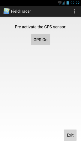
###Home At first the application proposes you to pre activate the GPS sensor. This can be useful when there is no mobile reception, the sensor cannot use the Assisted-GPS and thus takes up to 5 minutes to find a signal.
The signal is then acquired and an user can start to trace or to note Point of Interests.
As shown in the menu, the application is divided in 4 activities:
- A GPS tracing activity to record in GPX or in plain text
- A traces sharing and POI sharing activity that uses Serval Rhizome and from where an user can set automated sharing preferences
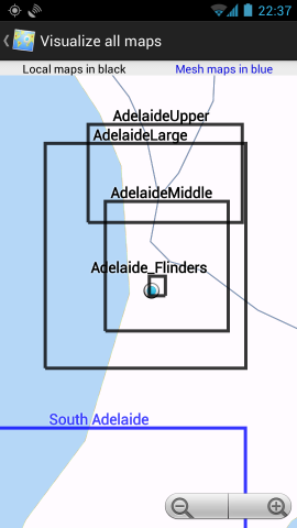
- A tools activity to show all the maps in the network and locally and to download one map
- A settings activity to set which recording format and which background map the application should use
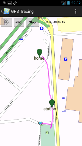
###Trace In the GPS tracing screen, an user can record a Point of Interest, and start recording a trace using the Toggle button. It is also possible to display the last recorded trace from the menu.
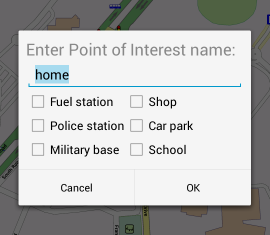
When adding a Point of Interest, an user can specify which type and name should be used. The POI will then be displayed.
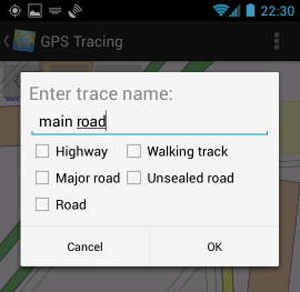
It works in the same way for the traces.
###Share Under the share screen it is possible to set automated sharing of traces and POI. They will then be automatically spread in the mesh network using Serval.
Under the tools screen it is possible to download a background map from the mesh
It is possible to visualize the background maps from the mesh network and from the local storage. This can be used for instance to know which map should be downloaded.
It is possible to specify the background map used for tracing and which format should be used for traces (GPX or Text)
##The Serval Project and Mapsforge##
###Serval The application uses the Serval Mesh for sharing and getting data from a mesh between multiple phones. Serval can actually not only uses a mesh configuration but also a base-station <-> clients network.
See http://www.servalproject.org/
###Mapsforge The application uses the Mapsforge library to display background maps without having to pull them from Internet.
See https://code.google.com/p/mapsforge/
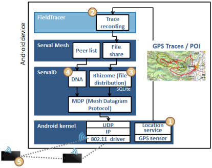
##Software stack used When diffusing the traces within the team:
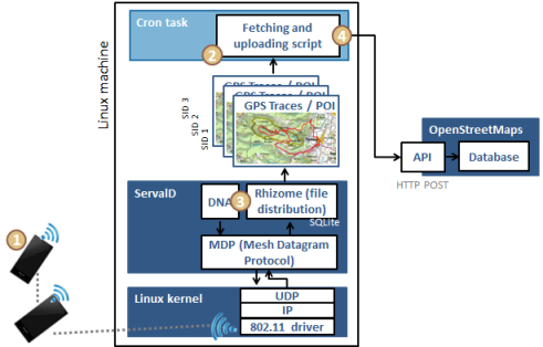
When uploading the traces to OpenStreetMap:
##Installation##
On Android phones:
- Get the Serval Mesh application (Google Play: https://play.google.com/store/apps/details?id=org.servalproject )
- Configure Serval Mesh with a phone number and a name
- Download the git source code with
git clone https://github.com/LoicLWRT/FieldTracer.git - Open the project under Eclipse or compile directly with
ant - OR directly install the APK from android_app/bin/FieldTracer.apk
- Get a Mapsforge map of the zone you plan to trace from http://download.bbbike.org/osm/
- Copy the map to the
/sdcard/FieldTracer/folder - You are ready to go :)
For the OpenStreetMap traces uploader:
- Get the serval-dna source code with
git clone https://github.com/servalproject/serval-dna.git - Configure it with
autoreconf -f -ithen./configureandmake - Get the script https://github.com/LoicLWRT/FieldTracer/blob/master/unix_script/pushing_traces_to_OpenStreetMap.sh and place it in the serval-dna folder
- Configure and run the script to upload traces when one phone is connected to the Unix machine
##Future improvements##
- Core traces recording should be made as a service to improve continuous operation
- Mapsforge library could be migrated to the upcoming 0.4 when it is released
- Direct upload to OpenStreetMap from one mesh node without having to run the Unix script
- Automated creation of OpenStreetMap accounts linked to a SID to improve data separation between multiple team members
- Security assessment to prevent data tampering

