

The AIDERS toolkit is a web-based platform that offers various tools for collecting and analyzing emergency response data from UAV sensors. The incident commanders can also command, control and view the drones in real time in a 3D map environment. This enables incident commanders to extract knowledge about the field’s operational conditions and assist them in designing evidence-based response strategies.
There are also several other tools offered that are non-UAV related, such as visualizing static information (e.g a country's infrastructure), create georeferenced 3D objects, or simulate the propagation of a fire.
The toolkit is delivered in a containerized environment (Docker), along with an android application that is responsible for communicating with the UAV.
All the data are collected and stored locally on the machine the platform is installed.
- AIDERS Toolkit
- How to cite
- Requirements
- How to install
- License
- Contributors
- Contributing
- Data Flow
- Disclaimer
- Cool Features
- Demo Video
To be completed.
Since AIDERS runs in a containerized Linux environment, you'd need to have Docker installed and the host machine has to be a Linux distribution:
- Docker (Tested version: 20.10.11)
- Linux OS (Tested mostly on Linux Ubuntu 20.04, but any Linux distribution should work)
- Docker Compose (Tested version: 1.29.2)
- Open a terminal window and navigate to the root folder of the project
- Make sure the installation script is executable using the command
sudo chmod +x ./install.sh - Execute the installation script using the command
./install.sh - Follow the on-screen instructions
Further instructions can be found in AIDERS official site.
- AIDERS project is EUPL licensed, as found in the LICENSE file.
AIDERS was developed by:
- Panayiotis Kolios - Research Assistant Professor at KIOS and advisor of this project
- Giorgos Sofroniou - Research and Developer Engineer at KIOS
- Alexis Piperides - Research and Developer Engineer at KIOS
- Michalis Demetriou - Research and Developer Engineer at KIOS
- Amal Abed - Research and Developer Engineer at KIOS
- Christos Georgiades - Research and Developer Engineer at KIOS
and with the help of the following contributors:
- Rafael Makrigiorgis - Research and Developer Engineer at KIOS
- Andreas Anastasiou - PhD Student at KIOS
We would also like to thank the following external resources and libraries, which were used in the development of this software:
Everyone is welcome to participate in this project. Whether you are helping others to resolve issues, reporting a new issue that hasn't yet been discovered, suggesting a new feature that would benefit your workflow, or writing code (or tests, or scripts, or ...), we value your time and effort.
The path for contribution starts with the Issues. You can create a new issue in case you discover a new bug or you have a useful suggestion that you’d like to be implemented. If you want to contribute code, fork this repo to your own account. Make your commits on your dev branch (or one based on dev). Once you are finished, you can open a Pull Request to test the code and discuss merging your changes back into the community repository.
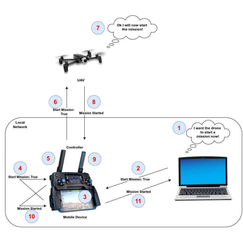
Following diagram shows how the data travel in the local network
This is an open source software, and is provided to you "as is" without any warranties or guarantees. We make no representations or warranties of any kind, express or implied, about the completeness, accuracy, reliability, suitability or availability with respect to the software. Any reliance you place on the information provided by this software is strictly at your own risk.


Click here to view a demonstration video that shows most of AIDERS functionalities