This repository contains the code for a plugin for QGIS, called "Susceptibility Zoning plugin" (SZ-plugin), aiming at creating maps of susceptibility to various natural forcing elements.
The plugin has been developed with a main focus and application towards landslides susceptibility, but it can be applied to different types of natural events or inter-disciplinary applications.
The plugin uses several type of statistical model for susceptibility evaluation, such as:
- Weight of Evidence
- Frequency Ratio
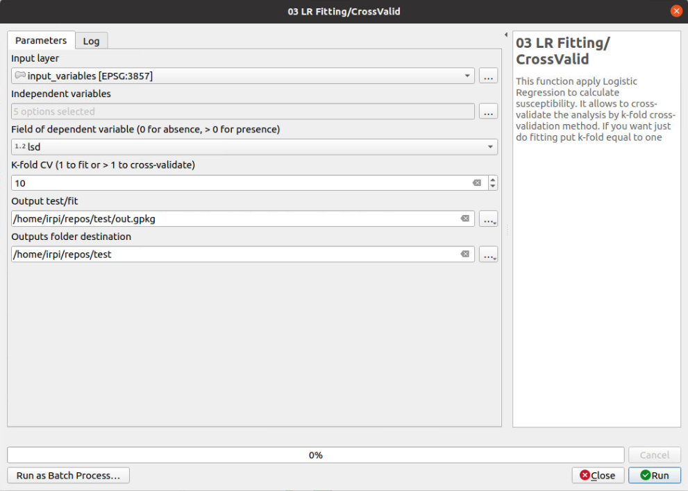
- Logistic Regression
- Decision Tree
- Support Vector Machine
- Random Forest
The plugin allows to cross-validate the results by simple random selection of test/train samples or allows to cross-validate by k-fold cross-validation method.
The SZ plugin is not an official QGIS plugin.
You need to install the basic dependencies to run the project on your system using pip (visit the website to install pip):
Windows, open OSGeo4W Shell (it is provided with QGIS installation) then launch the commands
cd path/to/downloded/folder/sz
pip install -r requirements.txt
or you can install them separately
Linux, open prompt (Ctrl+Alt+t) and run
cd path/to/downloded/folder/sz
pip3 install -r requirements_linux_mac.txt
or you can install them separately using sudo apt-get install python3-library
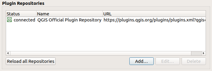
It can be installed on QGIS3.x adding the Plugin Repository to QGIS manage and install plugins:
- flag
show also experimental plugins
- add plugin repository
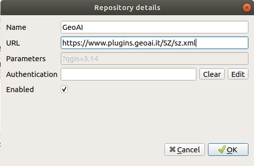
- edit repository and add https://www.plugins.geoai.it/SZ/sz.xml
or
cloning the GitHub repository or downloading it as zip file (and than unzipping it) and copying the sz_module folder in your local python/plugin folder (read here for more information).
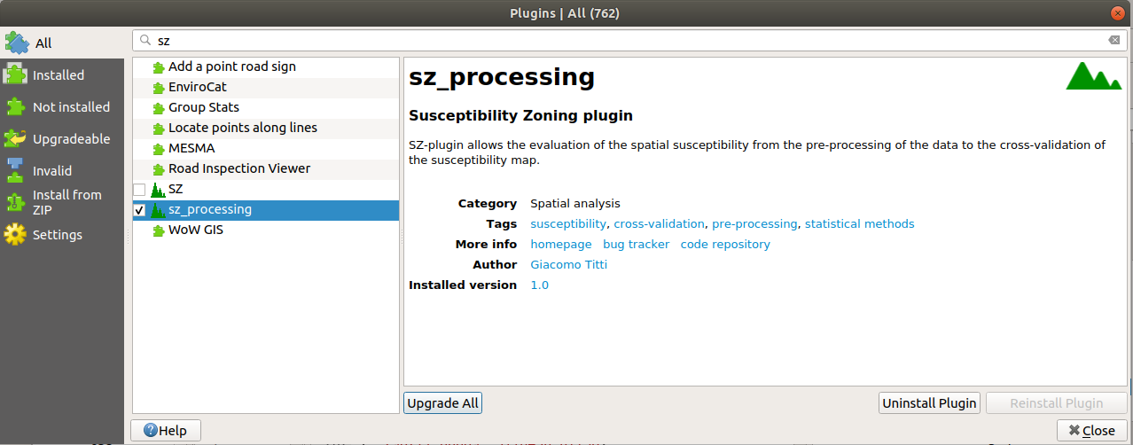
Lunch QGIS 3.x, and abilitate the plugin from manage and install plugin/installed/sz_processing
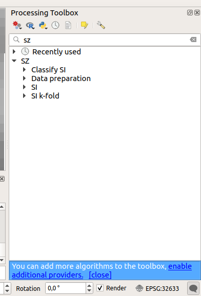
At the end you should have the SZ plugin in your processing toolbox
The functions are grouped into 3 cathegories:
- Data preparation
- SI
- SI k-fold
- Classify SI
Data preparation functions can be used for data pre-processing SI functions run the statistic models for susceptibility, cross-validate by a simple random selection of train/test samples and evaluate the prediction capacity by ROC curves SI k-fold functions run the statistic models for susceptibility, cross-validate by k-fold method and evaluate the prediction capacity by ROC curves Classify SI functions allows to cathegorize the susceptibility index into n classes on the base of AUC maximization.
Input data for SI k-fold or SI functions should be a vector layer with a number of fields for independet variables ans a field for the dependent variable classified binomially: 0 for absence, >0 for presence.
A dataset and QGIS project are available in test folder to test the plugin.
video tutorial: https://www.youtube.com/watch?v=XpsiCkVF11s
Titti G, Sarretta A, Lombardo L, Crema S, Pasuto A and Borgatti L (2022) Mapping Susceptibility With Open-Source Tools: A New Plugin for QGIS. Front. Earth Sci. 10:842425. doi: 10.3389/feart.2022.842425
A few examples and references about applications
Titti G, Sarretta A, Lombardo L, Crema S, Pasuto A and Borgatti L (2022) Mapping Susceptibility With Open-Source Tools: A New Plugin for QGIS. Front. Earth Sci. 10:842425. doi: 10.3389/feart.2022.842425
Titti, G., van Westen, C., Borgatti, L., Pasuto, A., & Lombardo, L. (2021). When Enough Is Really Enough? On the Minimum Number of Landslides to Build Reliable Susceptibility Models. Geosciences, 11(11), 469.
Titti, G., Borgatti, L., Zou, Q., Cui, P., & Pasuto, A. (2021). Landslide susceptibility in the Belt and Road Countries: continental step of a multi-scale approach. Environmental Earth Sciences, 80(18), 1-18.10.1007/s12665-021-09910-1
Titti, G., Borgatti, L., Zou, Q., Pasuto, A., 2019. Small-Scale landslide Susceptibility Assessment. The Case Study of the Southern Asia. Proceedings 30, 14. 10.3390/proceedings2019030014
A list of presentations made about the plugin and its applications
Titti, Giacomo, Sarretta, Alessandro, Crema, Stefano, Pasuto, Alessandro, & Borgatti, Lisa. (2020, March). Sviluppo e applicazione del plugin Susceptibility zoning per il supporto alla pianificazione territoriale. Zenodo. 10.5281/zenodo.3723353
Giacomo Titti, Alessandro Sarretta and Luigi Lombardo, Padova, November 2021
please cite as: Giacomo Titti, Alessandro Sarretta and Luigi Lombardo. (2021). CNR-IRPI-Padova/SZ: SZ plugin (Version v1.0). Zenodo.
If you have any problem, please write to giacomotitti@gmail.com

