Robot-Centric Elevation Mapping
Overview
This is a ROS package developed for elevation mapping with a mobile robot. The software is designed for (local) navigation tasks with robots which are equipped with a pose estimation (e.g. IMU & odometry) and a distance sensor (e.g. structured light (Kinect, RealSense), laser range sensor, stereo camera). The provided elevation map is limited around the robot and reflects the pose uncertainty that is aggregated through the motion of the robot (robot-centric mapping). This method is developed to explicitly handle drift of the robot pose estimation.
This is research code, expect that it changes often and any fitness for a particular purpose is disclaimed.
The source code is released under a BSD 3-Clause license.
Author: Péter Fankhauser
Co-Author: Maximilian Wulf
Affiliation: ANYbotics
Maintainer: Maximilian Wulf, mwulf@anybotics.com
This projected was initially developed at ETH Zurich (Autonomous Systems Lab & Robotic Systems Lab).
This work is conducted as part of ANYmal Research, a community to advance legged robotics.

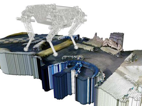
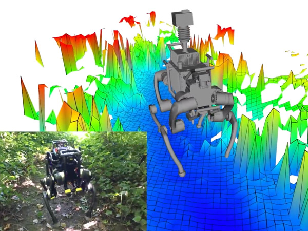
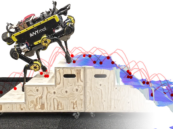
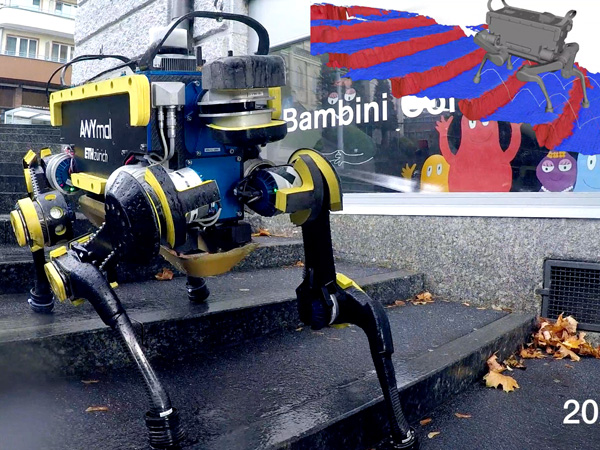
Videos of the elevation mapping software in use:
Citing
The robot-centric elevation mapping methods used in this software are described in the following paper (available here). If you use this work in an academic context, please cite the following publication(s):
-
P. Fankhauser, M. Bloesch, and M. Hutter, "Probabilistic Terrain Mapping for Mobile Robots with Uncertain Localization", in IEEE Robotics and Automation Letters (RA-L), vol. 3, no. 4, pp. 3019–3026, 2018. (PDF)
@article{Fankhauser2018ProbabilisticTerrainMapping, author = {Fankhauser, P{\'{e}}ter and Bloesch, Michael and Hutter, Marco}, doi = {10.1109/LRA.2018.2849506}, title = {Probabilistic Terrain Mapping for Mobile Robots with Uncertain Localization}, journal = {IEEE Robotics and Automation Letters (RA-L)}, volume = {3}, number = {4}, pages = {3019--3026}, year = {2018} } -
P. Fankhauser, M. Bloesch, C. Gehring, M. Hutter, and R. Siegwart, "Robot-Centric Elevation Mapping with Uncertainty Estimates", in International Conference on Climbing and Walking Robots (CLAWAR), 2014. (PDF)
  @inproceedings{Fankhauser2014RobotCentricElevationMapping,
    author = {Fankhauser, P\'{e}ter and Bloesch, Michael and Gehring, Christian and Hutter, Marco and Siegwart, Roland},
    title = {Robot-Centric Elevation Mapping with Uncertainty Estimates},
    booktitle = {International Conference on Climbing and Walking Robots (CLAWAR)},
    year = {2014}
  }
Installation
Dependencies
This software is built on the Robotic Operating System (ROS), which needs to be installed first. Additionally, the Robot-Centric Elevation Mapping depends on following software:
- Grid Map (grid map library for mobile robots)
- kindr (kinematics and dynamics library for robotics),
- kindr_ros (ROS wrapper for kindr),
- Point Cloud Library (PCL) (point cloud processing),
- Eigen (linear algebra library).
Building
In order to install the Robot-Centric Elevation Mapping, clone the latest version from this repository into your catkin workspace and compile the package using ROS.
cd catkin_workspace/src
git clone https://github.com/anybotics/elevation_mapping.git
cd ../
catkin config --cmake-args -DCMAKE_BUILD_TYPE=Release
catkin build
Unit Tests
Build tests with
roscd elevation_mapping
catkin build --catkin-make-args run_tests -- --this
Run the tests with
rostest elevation_mapping elevation_mapping.test -t
Basic Usage
In order to get the Robot-Centric Elevation Mapping to run with your robot, you will need to adapt a few parameters. It is the easiest if duplicate and adapt all the parameter files that you need to change from the elevation_mapping_demos package (e.g. the simple_demo example). These are specifically the parameter files in config and the launch file from the launch folder.
TurtleBot3 Waffle Simulation
A running example is provided, making use of the Turtlebot3 simulation environment. This example can be used to test elevation mapping, as a starting point for further integration.
To start with, the Turtlebot3 simulation dependencies need to be installed:
sudo apt install ros-melodic-turtlebot3*
The elevation mapping demo together with the turtlebot3 simulation can be started with
roslaunch elevation_mapping_demos turtlesim3_waffle_demo.launch
To control the robot with a keyboard, a new terminal window needs to be opened (remember to source your ROS environment). Then run
export TURTLEBOT3_MODEL=waffle
roslaunch turtlebot3_teleop turtlebot3_teleop_key.launch
Velocity inputs can be sent to the robot by pressing the keys a, w,d, x. To stop the robot completely, press s.
Nodes
Node: elevation_mapping
This is the main Robot-Centric Elevation Mapping node. It uses the distance sensor measurements and the pose and covariance of the robot to generate an elevation map with variance estimates.
Subscribed Topics
-
/points(sensor_msgs/PointCloud2)The distance measurements.
-
/pose(geometry_msgs/PoseWithCovarianceStamped)The robot pose and covariance.
-
/tf(tf/tfMessage)The transformation tree.
Published Topics
-
elevation_map(grid_map_msgs/GridMap)The entire (fused) elevation map. It is published periodically (see
fused_map_publishing_rateparameter) or after thetrigger_fusionservice is called. -
elevation_map_raw(grid_map_msgs/GridMap)The entire (raw) elevation map before the fusion step.
Services
-
trigger_fusion(std_srvs/Empty)Trigger the fusing process for the entire elevation map and publish it. For example, you can trigger the map fusion step from the console with
rosservice call /elevation_mapping/trigger_fusion -
get_submap(grid_map_msgs/GetGridMap)Get a fused elevation submap for a requested position and size. For example, you can get the fused elevation submap at position (-0.5, 0.0) and size (0.5, 1.2) described in the odom frame and save it to a text file form the console with
rosservice call -- /elevation_mapping/get_submap odom -0.5 0.0 0.5 1.2 [] -
get_raw_submap(grid_map_msgs/GetGridMap)Get a raw elevation submap for a requested position and size. For example, you can get the raw elevation submap at position (-0.5, 0.0) and size (0.5, 1.2) described in the odom frame and save it to a text file form the console with
rosservice call -- /elevation_mapping/get_raw_submap odom -0.5 0.0 0.5 1.2 [] -
clear_map(std_srvs/Empty)Initiates clearing of the entire map for resetting purposes. Trigger the map clearing with
rosservice call /elevation_mapping/clear_map -
masked_replace([grid_map_msgs/SetGridMap])Allows for setting the individual layers of the elevation map through a service call. The layer mask can be used to only set certain cells and not the entire map. Cells containing NAN in the mask are not set, all the others are set. If the layer mask is not supplied, the entire map will be set in the intersection of both maps. The provided map can be of different size and position than the map that will be altered. An example service call to set some cells marked with a mask in the elevation layer to 0.5 is
rosservice call /elevation_mapping/masked_replace "map: info: header: seq: 3 stamp: {secs: 3, nsecs: 80000000} frame_id: 'odom' resolution: 0.1 length_x: 0.3 length_y: 0.3 pose: position: {x: 5.0, y: 0.0, z: 0.0} orientation: {x: 0.0, y: 0.0, z: 0.0, w: 0.0} layers: [elevation,mask] basic_layers: [elevation] data: - layout: dim: - {label: 'column_index', size: 3, stride: 9} - {label: 'row_index', size: 3, stride: 3} data_offset: 0 data: [0.5, 0.5, 0.5, 0.5, 0.5, 0.5, 0.5, 0.5, 0.5] - layout: dim: - {label: 'column_index', size: 3, stride: 9} - {label: 'row_index', size: 3, stride: 3} data_offset: 0 data: [0, 0, 0, .NAN, .NAN, .NAN, 0, 0, 0] outer_start_index: 0 inner_start_index: 0" -
save_map(grid_map_msgs/ProcessFile)Saves the current fused grid map and raw grid map to rosbag files. Field
topic_namemust be a base name, i.e. no leading slash character (/). If fieldtopic_nameis empty, thenelevation_mapis used per default. Example with default topic namerosservice call /elevation_mapping/save_map "file_path: '/home/integration/elevation_map.bag' topic_name: ''" -
load_map(grid_map_msgs/ProcessFile)Loads the fused grid map and raw grid map from rosbag files. Field
topic_namemust be a base name, i.e. no leading slash character (/). If fieldtopic_nameis empty, thenelevation_mapis used per default. Example with default topic namerosservice call /elevation_mapping/load_map "file_path: '/home/integration/elevation_map.bag' topic_name: ''" -
disable_updates(std_srvs/Empty)Stops updating the elevation map with sensor input. Trigger the update stopping with
rosservice call /elevation_mapping/disable_updates {} -
enable_updates(std_srvs/Empty)Start updating the elevation map with sensor input. Trigger the update starting with
rosservice call /elevation_mapping/enable_updates {}
Parameters
-
DEPRECATED point_cloud_topic(string, default: "/points")The name of the distance measurements topic. Use input_sources instead.
-
input_sources(list of input sources, default: none)Here you specify your inputs to elevation mapping, currently "pointcloud" inputs are supported.
Example configuration:
input_sources:
    front: # A name to identify the input source
      type: pointcloud # Supported types: pointcloud
      topic: /lidar_front/depth/points
      queue_size: 1
      publish_on_update: true # Wheter to publish the elevation map after a callback from this source.
    rear:
      type: pointcloud
      topic: /lidar_rear/depth/points
      queue_size: 5
      publish_on_update: false
No input sources can be configured with an empty array:
input_sources: []
-
robot_pose_topic(string, default: "/robot_state/pose")The name of the robot pose and covariance topic.
-
base_frame_id(string, default: "/robot")The id of the robot base tf frame.
-
map_frame_id(string, default: "/map")The id of the tf frame of the elevation map.
-
track_point_frame_id(string, default: "/robot")The elevation map is moved along with the robot following a track point. This is the id of the tf frame in which the track point is defined.
-
track_point_x,track_point_y,track_point_z(double, default: 0.0, 0.0, 0.0)The elevation map is moved along with the robot following a track point. This is the position of the track point in the
track_point_frame_id. -
robot_pose_cache_size(int, default: 200, min: 0)The size of the robot pose cache.
-
min_update_rate(double, default: 2.0)The mininum update rate (in Hz) at which the elevation map is updated either from new measurements or the robot pose estimates.
-
fused_map_publishing_rate(double, default: 1.0)The rate for publishing the entire (fused) elevation map.
-
relocate_rate(double, default: 3.0)The rate (in Hz) at which the elevation map is checked for relocation following the tracking point.
-
length_in_x,length_in_y(double, default: 1.5, min: 0.0)The size (in m) of the elevation map.
-
position_x,position_y(double, default: 0.0)The position of the elevation map center, in the elevation map frame. This parameter sets the planar position offsets between the generated elevation map and the frame in which it is published (
map_frame_id). It is only useful if notrack_point_frame_idparameter is used. -
resolution(double, default: 0.01, min: 0.0)The resolution (cell size in m/cell) of the elevation map.
-
min_variance,max_variance(double, default: 9.0e-6, 0.01)The minimum and maximum values for the elevation map variance data.
-
mahalanobis_distance_threshold(double, default: 2.5)Each cell in the elevation map has an uncertainty for its height value. Depending on the Mahalonobis distance of the existing height distribution and the new measurements, the incoming data is fused with the existing estimate, overwritten, or ignored. This parameter determines the threshold on the Mahalanobis distance which determines how the incoming measurements are processed.
-
sensor_processor/ignore_points_above(double, default: inf) A hard threshold on the height of points introduced by the depth sensor. Points with a height over this threshold will not be considered valid during the data collection step. -
sensor_processor/ignore_points_below(double, default: -inf) A hard threshold on the height of points introduced by the depth sensor. Points with a height below this threshold will not be considered valid during the data collection step. -
multi_height_noise(double, default: 9.0e-7)Noise added to measurements that are higher than the current elevation map at that particular position. This noise-adding process is only performed if a point falls over the Mahalanobis distance threshold. A higher value is useful to adapt faster to dynamic environments (e.g., moving objects), but might cause more noise in the height estimation.
-
min_horizontal_variance,max_horizontal_variance(double, default: pow(resolution / 2.0, 2), 0.5)The minimum and maximum values for the elevation map horizontal variance data.
-
enable_visibility_cleanup(bool, default: true)Enable/disable a separate thread that removes elements from the map which are not visible anymore, by means of ray-tracing, originating from the sensor frame.
-
visibility_cleanup_rate(double, default: 1.0)The rate (in Hz) at which the visibility clean-up is performed.
-
enable_continuous_cleanup(bool, default: false)Enable/disable a continuous clean-up of the elevation map. If enabled, on arrival of each new sensor data the elevation map will be cleared and filled up only with the latest data from the sensor. When continuous clean-up is enabled, visibility clean-up will automatically be disabled since it is not needed in this case.
-
num_callback_threads(int, default: 1, min: 1) The number of threads to use for processing callbacks. More threads results in higher throughput, at cost of more resource usage. -
postprocessor_pipeline_name(string, default: postprocessor_pipeline)The name of the pipeline to execute for postprocessing. It expects a pipeline configuration to be loaded in the private namespace of the node under this name. E.g.:
  <node pkg="elevation_mapping" type="elevation_mapping" name="elevation_mapping" output="screen">
      ...
      <rosparam command="load" file="$(find elevation_mapping_demos)/config/postprocessor_pipeline.yaml" />
  </node>
A pipeline is a grid_map_filter chain, see grid_map_demos/filters_demo.yaml and ros / filters for more information.
-
postprocessor_num_threads(int, default: 1, min: 1)The number of threads to use for asynchronous postprocessing. More threads results in higher throughput, at cost of more resource usage.
-
scanning_duration(double, default: 1.0)The sensor's scanning duration (in s) which is used for the visibility cleanup. Set this roughly to the duration it takes between two consecutive full scans (e.g. 0.033 for a ToF camera with 30 Hz, or 3 s for a rotating laser scanner). Depending on how dense or sparse your scans are, increase or reduce the scanning duration. Smaller values lead to faster dynamic object removal and bigger values help to reduce faulty map cleanups.
-
sensor_cutoff_min_depth,sensor_cutoff_max_depth(double, default: 0.2, 2.0)The minimum and maximum values for the length of the distance sensor measurements. Measurements outside this interval are ignored.
-
sensor_model_normal_factor_a,sensor_model_normal_factor_b,sensor_model_normal_factor_c,sensor_model_lateral_factor(double)The data for the sensor noise model.
Changelog
See Changelog
Bugs & Feature Requests
Please report bugs and request features using the Issue Tracker.