Try it out
- Leaflet Map https://jackdougherty.github.io/cth-storymaps-practice/
- Linked Google Sheets template https://docs.google.com/spreadsheets/d/1CsIRBZGWMIm_iYPsNS5FwOLTOlH6zasw8WbCFKGCQLk/edit#gid=0
Here's a quick summary, and you can read more details in Hands-On Data Visualization https://HandsOnDataViz.org/leaflet-storymaps-with-google-sheets.html
For this practice map, all of the map data is stored in two locations:
- open the linked Google Sheet to edit text and map data, add new chapters, or modify map settings
- upload new JPG and PNG images to the
mediafolder in GitHub
- Notice different tabs: Chapters, Options, Geocoding details
- Each spreadsheet row equals one storymap chapter, and can contain only one media element (such as a JPG or PNG image, audio file, video link, etc).
The Description field can hold multiple paragraphs for each chapter, but the text must be consistent with HTML coding. This means:
- Use straight single-quotes (also known as apostrophes) and double-quotes (
"), not curly quotes that are commonly created by word-processor tools. - To create a new paragraph, insert a double line-break (
<br><br>) - To enter links, use HTML tags to open in a new browser tab, such as:
.<br><br><a href='https://connecticuthistory.org/bridge-ornaments-help-tell-the-legend-of-the-windham-frog-fight/' target='_blank'>More</a> about Windham's Frog Fight
When working with large amounts of Description text, you may find it easiest to first use a text editor tool such as Atom Editor, create a file named temporary.html, set View > Toggle Soft Wrap, and paste and prepare your Description text there before copying and pasting back into the Google Sheet.
Also, install the Dumb-Quoter Atom Package to convert curly-quotes into straight-quotes with CTRL-ALT-' (or CTRL-OPTION-' on Mac).
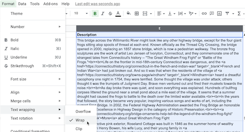
In Google Sheets, use Format > Text wrapping > Wrap to view the entire cell as needed, then go back to Overflow when done.
To geocode (find latitude and longitude coordinates), we recommend installing the free Geocoding by SmartMonkey add-on for Google Sheets. Insert your addresses in place of the samples in the Geocoding Details tab, then use Add-Ons > Geocoding > Geocode Details menu. Learn more in Hands-On Data Visualization https://handsondataviz.org/geocode.html
- organize your JPG or PNG files to match your location names (such as frog-bridge.jpg, frog-bridge2.jpg, etc.)
- highly recommended: use all lowercase file names (including .jpg, NOT .JPG)
- log into GitHub account, click on the media folder, and upload files as needed

